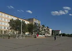
Arqalyq
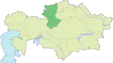
Arqalyq or Arkalyk (Kazakh: Arqalyq; Cyrillic: Арқалық, Russian: Аркалык) is a city in Kostanay Region, northern Kazakhstan. Earlier, it was the centre of Torgay Region, which was abolished in 1997. Established in 1956, it acquired the status of the city in 1965. The distance from the town of Arqalyq to Qostanai is 480 km (298 mi), to Astana is 670 km (416 mi). Population: 28,169 (2009 Census results);[1]45,736 (1999 Census results).[1]
Arqalyq
Arqalyq Арқалық | |
|---|---|
 | |
 Coat of arms | |
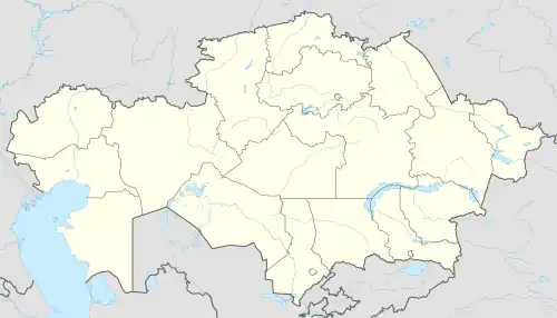 Arqalyq Location in Kazakhstan | |
| Coordinates: 50°14′53″N 66°55′40″E | |
| Country | Kazakhstan |
| Region | Kostanay Region |
| Government | |
| • Akim | Amirkhan Asanov |
| Time zone | UTC+6 |
| Climate | Dfa |
| Website | http://www.arkalyk.kz/ |
The Arqalyq Business Centre describes today's Arqalyq as "a city of miners, of regional administrators, and people excited to live in a regional center". Historically Arqalyq was a centre for the Soviet space programme. Cosmonauts would land on the huge central Kazakh steppe and come back to Arqalyq before heading to the Baikonur, the Soviet Union's premier "space city". Arqalyq is served by Arqalyq Airport.
The city is linked by rail communication with the regional center (terminal station on a branch Esil - Derzhavinsk - Arqalyq). Roads Kostanay - Arqalyq tarmac, but is severely broken in the state. Roads Zhezkazgan - Arqalyq ground, in the wet weather becomes difficult even for freight transport because of mud. There is an airport (located 6 kilometers north-east of the city), capable of class aircraft Tu-154, Tu-134, etc. In Soviet times, it carried out flights to many cities in Kazakhstan, but since the mid-1990s an airport has been practically abandoned and used only sporadically during the search and rescue for the planting of manned spaceaids.
History
Arqalyq was founded in 1956 as a settlement of geologists and builders. By birth, it was obliged to open after the war for deposits of bauxite (raw material for aluminum production). On May 17, 1956, in a joint decree of the CPSU Central Committee and USSR Council of Ministers a separate line was written: «On the basis of Amangeldy bauxite deposits construct and put into operation Torghay bauxite mines ». In the 1960s Arqalyq was declared the All-Union shock Komsomol building, there was the young people flock from all over the USSR. In 1965 Arqalyq received city status and in 1971 became the center of the newly created Torghay area.
In the 1980s the city reached its peak: it produced meat, poultry, and dairy. It functioned grain elevator, ceramic factory, sewing factory, the factory radio, factory built Aviamotornaya, Turgay bauxite mine (TBRU), which extracted up to 20% of bauxite ores in the USSR. But despite the industrial production, the economy of Torgay Region was behind other regions of Kazakhstan due to large agricultural sector which was 90%. The region constantly demanded subsidies from the national budget, so in June 1988 it was dissolved and its territory was divided between Kostanai and Aqmola areas. When the city stopped to be a regional center, some parts of the infrastructure was evacuated (for example, regional radio station), and a number of potential industrial sites was frozen.
In 1989, active inhabitants of Arqalyq organized committee to restore Torgay Region. In August 1990, Torgay Region was re-established, and Arqalyq become the regional center again.
Degradation of the city began in 1993-1994: production fell into decay. Migration began to other regions of Kazakhstan, Russia and Germany. Consequently, population of the city reduced. In 1991 it was 65,000 people, in 1999 it was 45,000, now it is 23,000 people. During 90s there were disrupted public services such as lengthy interruption of electricity, heat and water. In 1997, Turgay area has been disbanded again, and its territory was again moved into Kostanai and Akmola areas.
Some of the city districts as a part of #6, all of #7 and #9 were completely abandoned by the 2000s. Migration from the city was a complicated process which started in 90s. Full optimization stopped in 2000–2001. Enterprising businessmen from other regions of Kazakhstan dismantled the houses by removing building materials.
At the turn of 20th and 21st century, local authorities organized a campaign to relocate the remaining residents from the abandoned districts to the older city center, so the cost for municipal services would be reduced and communication would be significantly improved.
Currently, the city of Arqalyq is included in the list of depressed cities of Kazakhstan due to a very high level of unemployment. Industry in the city is virtually non-existent, except for maintaining the life of city and Torgayskogo bauxite mine, which is housed in SC «Aluminum of Kazakhstan». All produced bauxiteore is sent to the aluminum plant in Pavlodar, and other regions. Establishment of an aluminum smelter in Arqalyq is difficult due to lack of water.
Prospectives of Arqalyq are dual. On the one hand, the town has the bauxite mine which over the next 15–20 years will exhaust deposits and it will be possible to extract refractory clay only. On the other hand, there are a number of other minerals such as Jean-Arkalykskoe field has the shallow bed (up to 50 meters); Akzhalskoe field nefritoidov has the jewelry and raw materials; Akbulakskoe field has white marble; Agyrzhalskoe field has black marble; Jean-Arkalykskoe has deposits of therapeutic mineral waters. Development of these fields could lead to the economic and social revival of the region.
Climate
In Arqalyq, the climate is cold and temperate. There is more rainfall in winter than in summer. The Köppen-Geiger climate classification is BSk. The average annual temperature in Arqalyq is 4.5 °C (40.1 °F). About 246 mm (9.69 in) of precipitation falls annually.
| Climate data for Arqalyq (1991-2020, extremes 1958-present) | |||||||||||||
|---|---|---|---|---|---|---|---|---|---|---|---|---|---|
| Month | Jan | Feb | Mar | Apr | May | Jun | Jul | Aug | Sep | Oct | Nov | Dec | Year |
| Record high °C (°F) | 6.0 (42.8) |
6.7 (44.1) |
19.6 (67.3) |
31.0 (87.8) |
36.1 (97.0) |
40.5 (104.9) |
42.6 (108.7) |
42.0 (107.6) |
40.0 (104.0) |
28.5 (83.3) |
14.2 (57.6) |
11.7 (53.1) |
42.6 (108.7) |
| Average high °C (°F) | −11.1 (12.0) |
−9.8 (14.4) |
−2.1 (28.2) |
12.3 (54.1) |
21.3 (70.3) |
26.6 (79.9) |
27.9 (82.2) |
27.0 (80.6) |
19.7 (67.5) |
11.2 (52.2) |
−0.9 (30.4) |
−8.1 (17.4) |
9.5 (49.1) |
| Daily mean °C (°F) | −14.9 (5.2) |
−14.1 (6.6) |
−6.7 (19.9) |
6.3 (43.3) |
14.6 (58.3) |
19.9 (67.8) |
21.2 (70.2) |
19.8 (67.6) |
12.9 (55.2) |
5.0 (41.0) |
−5.2 (22.6) |
−11.9 (10.6) |
3.9 (39.0) |
| Average low °C (°F) | −18.4 (−1.1) |
−18.1 (−0.6) |
−10.7 (12.7) |
1.0 (33.8) |
8.1 (46.6) |
13.5 (56.3) |
14.7 (58.5) |
13.2 (55.8) |
6.9 (44.4) |
0.3 (32.5) |
−8.4 (16.9) |
−15.4 (4.3) |
−1.1 (30.0) |
| Record low °C (°F) | −42.0 (−43.6) |
−42.2 (−44.0) |
−38.9 (−38.0) |
−24.8 (−12.6) |
−9.8 (14.4) |
−0.3 (31.5) |
2.0 (35.6) |
−3.0 (26.6) |
−9.2 (15.4) |
−22.0 (−7.6) |
−36.3 (−33.3) |
−41.0 (−41.8) |
−42.2 (−44.0) |
| Average precipitation mm (inches) | 20 (0.8) |
15 (0.6) |
17 (0.7) |
19 (0.7) |
22 (0.9) |
23 (0.9) |
25 (1.0) |
18 (0.7) |
18 (0.7) |
26 (1.0) |
22 (0.9) |
20 (0.8) |
245 (9.7) |
| Source: Pogoda.ru.net[2] | |||||||||||||
Educational Institution City
- Arqalyq pedagogical Institute named I. Altynsarin.
- Torghay humanities college.
- Torghay Agro-Technical College.
- Arqalyq Medical College.
- Arqalyq College of Economics and Law \Kazpotrebsoyuz\
- Arqalyq Kazakh-Turkish High School
Nature
Area is a hilly terrain with absolute marks 320–360 meters north of the city up to 390 m (1,280 ft). The radius of 6 km (4 mi) from the city are extensive mining (related to mining bauxite ore), the depth of 20–50 m.
The natural reservoirs are not numerous, except for two drying creeks Akjar (in the northern part of town) and Arkalyksay (in the southern part of town), running from the East to the West.
Natural wealth
Near the town of Arqalyq is 6 bauxite for the aluminum industry. This Arqalyq, Lower Ashut, Ushtobe, Northern, Upper Ashut and Aktas. These same deposits associated classes of refractory clay. In addition, the bauxite, the associated component is gallium, stocks of which is formed by 761 kilograms. At the distance of 5 km (3 mi) from the city there is another lead field "Jana-Arqalyq" under exploration. Among the associated components of the ore we can find yttrium, gold, silver, tin, and others. The reserves of Jana-Arqalyq deposit are estimated at 6 million tons of lead. In the same area there are 37 fields common minerals including 28-brick commodity, 4-building stone, construction sand 5. 100 km (62 mi) from the city there is Akzhal deposit of nephritis, which was mined in 1997 for extraction purposes of decorative facing stone. Within the radius of 70–100 km away from the city there are deposits with an estimated volume of 3-6 million cubic metres of White Akbulak Marble and deposits of Agirjal black marble with reserves of about 8 million cubic metres. Newspaper Torghay for 23 September 2005.
References
- "Население Республики Казахстан" [Population of the Republic of Kazakhstan] (in Russian). Департамент социальной и демографической статистики. Retrieved 8 December 2013.
- "Weather and Climate - The Climate of Omsk" (in Russian). Weather and Climate (Погода и климат). Retrieved 8 November 2021.
External links
- "City of Arqalyq". Archived from the original on 18 April 2005. Retrieved May 15, 2005.