Astron (ship)
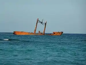
Astron (previously named Esmeralda and Bonnie) is a shipwreck located off the coast of Punta Cana in the Dominican Republic. She was a Russian-owned cargo ship built in France by Chantiers de l'Atlantique during 1957. She was 127 metres (417 feet) long, 27,990 gross tons, and was a motor ship.[1][3]
 The Astron shipwreck in 2008 | |
| History | |
|---|---|
| Name | Esmeralda |
| Operator | Compagnie Auxiliaire De Navigation[1] |
| Builder | Chantiers de l'Atlantique, Saint-Nazaire, France[1] |
| Yard number | L17[1] |
| Launched | 1957 |
| Out of service | 1972 |
| Fate | Acquired by Pontiac Shipping Co. Ltd 1972[1] |
| History | |
| Name | Bonnie |
| In service | 1972[1] |
| Out of service | 1976[1] |
| Fate | renamed Astron[1] |
| History | |
| Name | Astron |
| Owner | Pontiac Shipping Co. Ltd[1] |
| Port of registry | Panama |
| In service | 1976[1] |
| Identification | IMO number: 5106380[1] |
| Fate | Run aground in off Punta Cana, 7 April 1978[1] |
| General characteristics | |
| Type | Oil tanker |
| Tonnage | |
| Length | 127 m |
| Propulsion | Steam Turbine[1] |
| Speed | 16.5 knots (30.6 km/h; 19.0 mph)[1] |
Astron was delivering 60 tons of corn to Cuba on 7 April 1978, when she ran aground at Punta Cana during a storm. However, there is no hurricane or tropical storm listed during this date in the history of the Atlantic Hurricane season of 1978.[4] This ship either hit a mine, was torpedoed, or intentionally scuttled, evidenced by the extensive ripped steel of the lower hull.[5] She broke into two distinct sections with the bow above the water and the stern underwater, with 7,330 barrels of bunker fuel reported lost in the incident. The wreck is in water 16 metres (52 feet) deep, meaning it can be visited by scuba divers.[3]
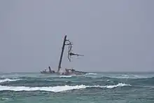
As of 2018 only a small portion remains above water.

References
- "MV Astron (+1978)". wrecksite.eu. The Wreck site. Retrieved 3 January 2012.
- "ASTRON". Marine Traffic. Retrieved 4 May 2016.
- Robson, Rob. "Astron Shipwreck". Rob-Robson.com. Archived from the original on 15 July 2011. Retrieved 28 February 2009.
- Lawrence, Miles (1979-01-29). "Atlantic Hurricane Season of 1978" (PDF). National Oceanic and Atmospheric Administration. Archived (PDF) from the original on 2022-09-27.
- Baker, Christopher (2008-05-01). Dominican Republic. National Geographic. p. 95. ISBN 978-1-4262-0232-2.