Avançon, Ardennes
Avançon (French pronunciation: [avɑ̃sɔ̃]) is a commune in the Ardennes département in the Grand Est region of northern France.
Avançon | |
|---|---|
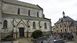
 View of the Church, cemetery, and town hall | |
 Coat of arms | |
Location of Avançon | |
 Avançon  Avançon | |
| Coordinates: 49°28′34″N 4°14′45″E | |
| Country | France |
| Region | Grand Est |
| Department | Ardennes |
| Arrondissement | Rethel |
| Canton | Château-Porcien |
| Intercommunality | Pays Rethélois |
| Government | |
| • Mayor (2020–2026) | Yvan Lefevre[1] |
| Area 1 | 20.99 km2 (8.10 sq mi) |
| Population | 340 |
| • Density | 16/km2 (42/sq mi) |
| Time zone | UTC+01:00 (CET) |
| • Summer (DST) | UTC+02:00 (CEST) |
| INSEE/Postal code | 08038 /08300 |
| 1 French Land Register data, which excludes lakes, ponds, glaciers > 1 km2 (0.386 sq mi or 247 acres) and river estuaries. | |
The inhabitants of the commune are known as Avançonnais or Avançonnaises.[3]
Geography
Avançon is located some 10 km south-west of Rethel and 11 km east of Asfeld. Access to the commune is by the D18 road from Acy-Romance in the north-east which passes through the commune to the village near the centre then continues west to Blanzy-la-Salonnaise. The D26 road goes from the village north to Taizy. The D150 goes south-west from the village to Saint-Loup-en-Champagne. The commune is entirely farmland.[4]
Neighbouring communes and villages
Heraldry
 Arms of Avançon, Ardennes |
Blazon: Azure, a fleur-de-lis Argent between three mullets Or.
|
Administration
List of Successive Mayors[5]
| From | To | Name |
|---|---|---|
| 1793 | 1807 | Rémy Tagnon |
| 1807 | 1830 | Guillaume Alexandre Monceau |
| 1830 | 1839 | Jean Trichet |
| 1839 | 1843 | Barthélémy Michelet |
| 1843 | 1876 | Jean Nicolas Rémy Legrand |
| 1876 | 1892 | Alexandre Paul Victor Koehler |
| 1892 | 1912 | Hubert Emmanuel Legros |
| 1912 | 1919 | Charles Eugène Michelet |
| 1919 | 1921 | Barthélémy Michelet |
| 1921 | 1929 | Edmond Désiré Lefevre |
| 1929 | 1965 | Rémy Achille Monceau |
| 1965 | 1994 | Bernard Edmond Lefevre |
| 1994 | 2001 | Marie-Hélène Michelet |
| 2001 | 2014 | Philippe Hourlier |
| 2014 | 2020 | Hubert Launois |
| 2020 | current | Yvan Lefevre |
Demography
In 2017 the commune had 313 inhabitants.
|
| ||||||||||||||||||||||||||||||||||||||||||||||||||||||||||||||||||||||||||||||||||||||||||||||||||||||||||||
| Source: EHESS[6] and INSEE[7] | |||||||||||||||||||||||||||||||||||||||||||||||||||||||||||||||||||||||||||||||||||||||||||||||||||||||||||||
Culture and heritage
See also
References
- "Répertoire national des élus: les maires". data.gouv.fr, Plateforme ouverte des données publiques françaises (in French). 2 December 2020.
- "Populations légales 2020". The National Institute of Statistics and Economic Studies. 29 December 2022.
- Inhabitants of Ardennes (in French)
- Google Maps
- List of Mayors of France (in French)
- Des villages de Cassini aux communes d'aujourd'hui: Commune data sheet Avançon, EHESS (in French).
- Population en historique depuis 1968, INSEE
- Ministry of Culture, Mérimée PA00078338 Church of Saint Remi (in French)
- Ministry of Culture, Palissy PM08000039 Eagle Lectern (in French)

External links
- Avançon on the old IGN website (in French)
- Avançon on Géoportail, National Geographic Institute (IGN) website (in French)
- Avançon on the 1750 Cassini Map
Wikimedia Commons has media related to Avançon, Ardennes.
This article is issued from Wikipedia. The text is licensed under Creative Commons - Attribution - Sharealike. Additional terms may apply for the media files.