Awatere Fault
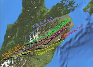
The Awatere Fault is an active dextral (right lateral) strike-slip fault in the northeastern part of South Island, New Zealand. It forms part of the Marlborough Fault System, which accommodates the transfer of displacement along the oblique convergent boundary between the Indo-Australian Plate and Pacific Plate, from the transform Alpine Fault to the Hikurangi Trench subduction zone.[1] The 1848 Marlborough earthquake was caused by rupture of the whole of the eastern section of the Awatere Fault.
| Awatere Fault | |
|---|---|
| Location | South Island, New Zealand |
| Country | New Zealand |
| Characteristics | |
| Segments | 2; Molesworth and Eastern |
| Length | 175km |
| Tectonics | |
| Plate | Australian Plate, Pacific Plate |
| Status | Active |
| Earthquakes | 1848 Marlborough earthquake |
| Type | dextral strike-slip fault |
| New Zealand geology database (includes faults) | |

Extent
The 175 km long Awatere Fault is formed of two main segments; the Molesworth section to the southwest and the Eastern section to the northeast.[2] A further strand links the southwestern end of the Eastern section to the Clarence Fault, passing through Barefell Pass.[3]
Molesworth section
The Molesworth segment of the Awatere Fault runs from close to the junction between the Alpine and Wairau Faults near Lake Tennyson, to near Molesworth Station in the northeast. It is about 55 km in length and consists of several smaller segments. This section has an overall strike of N75–80°E, giving local zones of transtension at some of the segment boundaries, such as at Isolated Flat.[4]
Eastern section
The Eastern section of the fault runs from Molesworth Station to the coast, near White Bluffs, without significant segmentation.[3] The Awatere River follows the trace of much of the eastern section of the fault, giving its name to the whole structure.
Recent seismicity
The Molesworth section appear to have moved twice since about 3000 years ago, in events with slip values of about 6–7 m.[4] Trenching at Saxton River at the eastern end of the Molesworth section suggests 8 ruptures since about 6,300 years ago, with an estimated mean recurrence of about 800 years.[5] Evidence from the eastern section of the fault suggests that there were 9–10 earthquakes in the period from 8610 BP to AD 1848. This gives a mean recurrence interval of 820–950 years.[6] In 1848 a minimum 105 km length section of the fault ruptured, causing an earthquake of an estimated magnitude of about 7.5 Mw. The rupture appears to have bypassed the Molesworth section of the fault, continuing on the southern strand through Barefell Pass.[3]
Seismic hazard
Seismic hazard on the Eastern section is considered low, with only about 150 years since the last major earthquake on that section and an estimated recurrence interval of 600–2500 years.[2]
References
- Langridge, R.; Campbell J.; Hill N.; Pere V.; Pope J.; Pettinga J.; Estrada B.; Berryman K. (2003). "Paleoseismology and slip rate of the Conway Segment of the Hope Fault at Greenburn Stream, South Island, New Zealand" (PDF). Annals of Geophysics. 46 (5). Retrieved 27 June 2010.
- Geotech Consulting Ltd (May 2003). "Identification of active fault traces in Marlborough District". Marlborough District Seismic Hazard Investigation Programme. Archived from the original on 22 May 2010. Retrieved 2 July 2010.
- Grapes, R.; Little T.A.; Downes G. (1998). "Rupturing of the Awatere Fault during the 1848 October 16 Marlborough earthquake, New Zealand: historical and present day evidence" (PDF). New Zealand Journal of Geology & Geophysics. 41 (4): 387–399. doi:10.1080/00288306.1998.9514818. Retrieved 2 July 2010.
- McCalpin, J.P. (1996). "Tectonic geomorphology and Holocene paleoseismicity of the Molesworth section of the Awatere Fault, South Island, New Zealand" (PDF). New Zealand Journal of Geology and Geophysics. 39 (1): 33–50. doi:10.1080/00288306.1996.9514693. Retrieved 2 July 2010.
- Little, T. "Stop 2: Awatere Fault - south of Dashwood Pass at Calrossie Station" (PDF). Field Trip Guides, Geological Society of New Zealand 50 Annual Conference, Kaikoura, New Zealand. p. 92. Archived from the original (PDF) on 25 May 2010. Retrieved 2 July 2010.
- Mason, D.P.M.; Little T.A.; van Dissen R.J. (2006). "Refinements to the paleoseismic chronology of the eastern Awatere Fault from trenches near Upcot Saddle, Marlborough, New Zealand". New Zealand Journal of Geology and Geophysics. 49 (3): 383–397. doi:10.1080/00288306.2006.9515175.