Bílá Lhota
Bílá Lhota (German: Weissöhlhütten) is a municipality and village in Olomouc District in the Olomouc Region of the Czech Republic. It has about 1,200 inhabitants.
Bílá Lhota | |
|---|---|
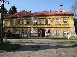 Bílá Lhota Castle, now the municipal office | |
 Flag  Coat of arms | |
 Bílá Lhota Location in the Czech Republic | |
| Coordinates: 49°42′34″N 16°58′30″E | |
| Country | |
| Region | Olomouc |
| District | Olomouc |
| First mentioned | 1350 |
| Area | |
| • Total | 18.22 km2 (7.03 sq mi) |
| Elevation | 395 m (1,296 ft) |
| Population (2023-01-01)[1] | |
| • Total | 1,167 |
| • Density | 64/km2 (170/sq mi) |
| Time zone | UTC+1 (CET) |
| • Summer (DST) | UTC+2 (CEST) |
| Postal codes | 783 21, 783 24 |
| Website | www |
Administrative parts
Villages of Červená Lhota, Hrabí, Hradečná, Měník, Pateřín and Řimice are administrative parts of Bílá Lhota.
This article is issued from Wikipedia. The text is licensed under Creative Commons - Attribution - Sharealike. Additional terms may apply for the media files.