Březiněves
Březiněves is a municipal district (městská část) and cadastral area (katastrální území) in Prague. It is located in the northern part of the city. As of 2018, there were 1576 inhabitants living in Březiněves.
Březiněves
Březiněves | |
|---|---|
Municipal District of Prague Cadastral Area of Prague | |
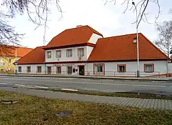 Historical pub building in Březiněves | |
 Flag  Coat of arms | |
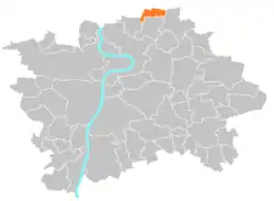 Location of Březiněves in Prague | |
| Coordinates: 50°9′57″N 14°29′06″E | |
| Country | Czech Republic |
| Region | Prague |
| District | Prague 8 |
| Government | |
| • Mayor | Jiří Haramul |
| Area | |
| • Total | 3.39 km2 (1.31 sq mi) |
| Population (2021) | |
| • Total | 1,821 |
| • Density | 540/km2 (1,400/sq mi) |
| Time zone | UTC+1 (CET) |
| • Summer (DST) | UTC+2 (CEST) |
| Postal code | 182 00 |
| Website | http://www.brezineves.com/ |
The first written record of Březiněves is from the 12th century. The village became part of Prague in 1974 with the last enlargement of the city.
Demographics
| Year | Pop. | ±% |
|---|---|---|
| 1869 | 208 | — |
| 1880 | 245 | +17.8% |
| 1890 | 287 | +17.1% |
| 1900 | 280 | −2.4% |
| 1910 | 265 | −5.4% |
| 1921 | 260 | −1.9% |
| 1930 | 384 | +47.7% |
| 1950 | 361 | −6.0% |
| 1961 | 412 | +14.1% |
| 1970 | 427 | +3.6% |
| 1980 | 516 | +20.8% |
| 1991 | 557 | +7.9% |
| 2001 | 667 | +19.7% |
| 2011 | 1,202 | +80.2% |
| 2021 | 1,821 | +51.5% |
| Source: Censuses[1][2] | ||
External links
Wikimedia Commons has media related to Březiněves.
- "Historický lexikon obcí České republiky 1869–2011 – Praha" (in Czech). Czech Statistical Office. 2015-12-21. pp. 7–8.
- "Population Census 2021: Population by sex". Public Database. Czech Statistical Office. 2021-03-27.
This article is issued from Wikipedia. The text is licensed under Creative Commons - Attribution - Sharealike. Additional terms may apply for the media files.