Bạch Đằng Quay
Bach Dang Quay (Vietnamese: Bến Bạch Đằng) is a wharf and park in District 1, downtown Ho Chi Minh City, Vietnam. It stretches along about 1.3 kilometres (0.81 mi) of the Saigon River from the Thủ Ngữ flagpole to the site of the former Ba Son Shipyard (now the Saigon – Ba Son complex) and covers an area of 23,400 square metres (252,000 sq ft).[1][2]
| Bạch Đằng Quay | |
|---|---|
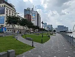
 Bach Dang Quay in 2023 | |
| Location | District 1, Ho Chi Minh City |
| Coordinates | 10°46′31″N 106°42′25″E |
| Area | 23,400 square metres (252,000 sq ft) |
History

According to scholar Pétrus Ký, the waterfront area at the end of rue Catinat was once called Bến Ngự (translating to "royal wharf"), the royal landing stage. He also revealed that it was known in Khmer as Compong-luong,[3] which suggests that its history may date back to the 17th century, when Saigon was still the Cambodian settlement of Prey Nokor.[4]

During the early years of French colonial rule, the Mercantile port of Saigon continued to use wharves immediately north of the arroyo Chinois extending as far as the Rond-point (modern-day Mê Linh Square). However, in 1881, these wharves were transformed into the River port and were entrusted to the management of the Compagnies des Messageries fluviales (the River Shipping Company), the replacement mercantile port was constructed in Khánh Hội (modern-day District 4).[4] This quayside area had its name changed quite often throughout the French colonial period. Initially quai de Donnai, the name was successively changed to quai Napoléon (1865), quai du Commerce (1870), quai Francis Garnier (1896) and finally quai le Myre de Vilers (1920).[5]: 300 On 11 August 1890, the Lieutenant-Governor of Cochinchina authorized the installation of a tramway track along the quay.[6]

Additionally, the quayside to the north of the River port and the Rond-point was used as the Naval port (Port de la marine) and controlled by the French Navy (Marine nationale française). This quay, initially called quai Primauguet and then changed to quai d'Argonne in 1920,[5]: 87 housed the Naval Commander’s headquarters (Hôtel du Commandant de la Marine), the Naval Artillery (Artillerie de Marine) and the Naval Barracks (Caserne de la Marine, later Caserne Francis-Garnier). The Saigon Naval Shipyard is located immediately north of the quay and stretches as far as the mouth of the arroyo de l’Avalanche.[4]
After the departure of the French, the River port was taken over by the Saigon Port Authority (Nha Thương cảng Sài Gòn). Meanwhile, the Naval port was managed first by the Republic of Vietnam and later by the Socialist Republic of Vietnam Ministries of Defence.[4] Both quai le Myre de Vilers and quai d'Argonne were given a single Vietnamese name, Bến Bạch Đằng, by the South Vietnamese government in 1955.[7]
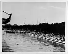
.jpg.webp)
The colonial naval barracks and artillery buildings continued to be used by naval personnel until the 1990s, but since that time the old artillery compound has been demolished to redevelop new hotels and office blocks. The former Caserne Francis Garnier barracks, now located at 1A Tôn Đức Thắng, is the only surviving operational naval installation in this area.[4]
In 2015, the government of Ho Chi Minh City decided to close the River port at Bach Dang Quay to renovate the wharf and park.[8][9] In the same year, the Naval port was also closed following the relocation of the Ba Son Shipyard to Bà Rịa–Vũng Tàu province.[10] The renovation of the area was eventually carried out in 2021[11] and completed in 2022, which gave the park its current appearance with the grass areas and walkways forming the shape of lotus flowers.[12] According to the Ho Chi Minh City Department of Transportation, by the end of 2022, the only inland waterway transport services being operated at Bach Dang Quay are the Saigon Waterbus and the hydrofoil service to Vũng Tàu.[13]
References
- "HCM City to renovate Bạch Đằng Wharf Park". Viet Nam News. November 10, 2020.
- Son Nghia; Nguyen Luan (December 26, 2014). "Bach Dang Wharf". Vietnam Pictorial.
- Trương, Jean Baptiste Pétrus Vĩnh Ký (1885). Souvenirs historiques sur Saïgon et ses environs: conférence faite au collège des interprètes (in French). Saigon: Imprimerie coloniale. p. 18.
- Doling, Tim (March 11, 2018). "A Short History of Saigon Port". Historic Vietnam.
- Baudrit, André (1943). Guide historique des rues de Saigon (in French). Saigon: S.I.L.I.
- "Arrêté autorisant la Société générale des tramways à vapeur de Cochinchine à établir un passage à niveau, une plaque tournante et une voie parallèle sur le quai du Commerce". Bulletin officiel de l'Indochine française, Première partie, Cochinchine et Cambodge, année 1890, n°8 (in French): 724. 1890.
- Guillaume, Xavier; Guillaume, Marie-Christine (2004). La Terre du Dragon – Tome I (in French). Paris: Publibook. p. 62.
- "Ho Chi Minh City extends operation of Bach Dang Wharf at last minute". Tuoi Tre News. January 17, 2015.
- "Wharf closure leaves Saigon river tours 'grounded'". Tuoi Tre News. December 5, 2016.
- Thayer, Carlyle A. (2018). "Force Modernization: Vietnam". Southeast Asian Affairs: 439. JSTOR 26492790.
- "Ho Chi Minh City to move, fell 178 trees in downtown park". Tuoi Tre News. May 26, 2021.
- Duy Khang; Le Phan (March 17, 2022). "Newly renovated parks inaugurated in downtown Ho Chi Minh City". Tuoi Tre News.
- Thu Dung; Lưu Duyên (December 20, 2022). "Cầu tàu công viên bến Bạch Đằng và cầu tàu Ba Son sẽ khai thác ra sao?". TuoiTre Online (in Vietnamese).
External links
 Media related to Bach Dang Quay at Wikimedia Commons