B8 road (Namibia)
B8 road often known as the Golden Highway [1] is one of the national highways of Namibia. It leads from the B1 at Otavi via Grootfontein and Rundu through the Caprivi Strip to the border town of Katima Mulilo (where there is a short 4-kilometre (2.5 mi) spur section, also designated B8, crossing into Zambia) and further on to the Botswana border at Ngoma. The section from Otavi to Katima Mulilo forms part of the Walvis Bay-Ndola-Lubumbashi Development Road.
 | ||||
|---|---|---|---|---|
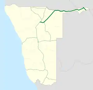 Map of the B8. | ||||
| Route information | ||||
| Maintained by Roads Authority Namibia | ||||
| Length | 933 km (580 mi) Includes the main route between Otavi and Ngoma, and a short 4 km (2.5 mi) spur section also designated B8 between Katima Mulilo and the Katima Mulilo Bridge. | |||
| Main route | ||||
| Length | 929 km (577 mi) | |||
| West end | ||||
| Major intersections | ||||
| East end | A33 A33 at the Botswanan border at Ngoma | |||
| Katima Mulilo spur | ||||
| Length | 4 km (2.5 mi) | |||
| South end | ||||
| North end | ||||
| Location | ||||
| Country | Namibia | |||
| Major cities | Otavi, Grootfontein, Rundu, Divundu, Katima Mulilo | |||
| Highway system | ||||
| ||||
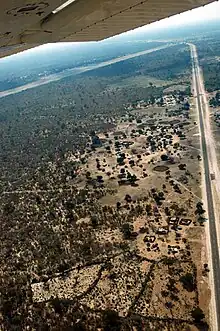
Crossing the Trans–Caprivi Highway on approach to Katima's Mpacha Airport.
Populated places
from west to east
- Otavi
- Kombat
- Grootfontein
- Mile 30, 30 miles (48 km) south of Rundu[2]
- Rundu
- Ndiyona
- Divundu
- Kongola
- Katima Mulilo
- Ngoma
 Eugen Kakukuru Street in Rundu, Namibia, which leads onto National Road B8.
References
- http://www.namibia-travel-guide.com/bradt_guide.asp?bradt=416>
- Labersweiler, Sabine (7 February 2011). "Kapelle in Mile 30 eingeweiht" [Chapel consecrated at Mile 30] (in German). Evangelical Lutheran Provost Brunswick. Archived from the original on 24 April 2012.
| Freeways |
| |
|---|---|---|
| Trunk routes | ||
| Secondary routes | ||
| International routes | ||
This article is issued from Wikipedia. The text is licensed under Creative Commons - Attribution - Sharealike. Additional terms may apply for the media files.