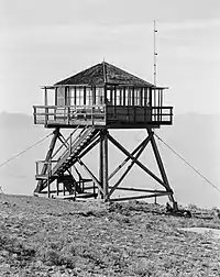
Badger Mountain (Douglas County, Washington)
Badger Mountain is a mountain in Douglas County in the U.S. state of Washington. It is the highest point in Douglas County,[2] and is located east of the Columbia River and northeast of Wenatchee. Badger Mountain is part of the Columbia Plateau.
| Badger Mountain | |
|---|---|
 Fire lookout on top of Badger Mountain | |
| Highest point | |
| Elevation | 4,262 ft (1,299 m) NAVD 88[1] |
| Prominence | 2,674 ft (815 m)[2] |
| Listing | Mountains of Washington (state) |
| Coordinates | 47°35′02″N 120°10′46″W[1] |
| Geography | |
 Badger Mountain | |
| Parent range | Columbia River Plateau |
| Topo map | USGS Orondo |
The Badger Mountain Ski Area is located on the mountain's northeastern flank.
According to Edmond S. Meany, a Mt. St. Pierre named by Lt. Johnson of the United States Exploring Expedition in 1841 was probably Badger Mountain.[3] Its present name goes back to settlers and refers to the native animal, the badger.[4]
References
- "Ski". NGS Data Sheet. National Geodetic Survey, National Oceanic and Atmospheric Administration, United States Department of Commerce. Retrieved 2010-12-29.
- "Badger Mountain, Washington". Peakbagger.com. Retrieved 2008-10-02.
- Meany 1920, p. 274.
- Hitchman 1985, p. 11.
Sources
- Meany, Edmond S. (October 1920). "Origin of Washington Geographic Names (Continued)". The Washington Historical Quarterly. 11 (4): 274–293. JSTOR 40473841.
- Hitchman, Robert (1985). Place Names of Washington. Washington State Historical Society.
External links
- "Badger Mountain". Geographic Names Information System. United States Geological Survey, United States Department of the Interior.
- "Badger Mountain". SummitPost.org. Retrieved 2011-05-07.
This article is issued from Wikipedia. The text is licensed under Creative Commons - Attribution - Sharealike. Additional terms may apply for the media files.