Capitol Peak (Thurston County)
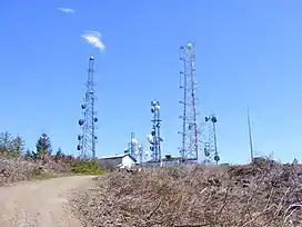
Capitol Peak is a 2,658-foot (810 m)[1] peak in the Black Hills in the U.S. state of Washington. It is one of the two highest peaks in the Black Hills, along with Larch Mountain.[4] Capitol Peak is located in the Capitol State Forest. There is a partially paved road to the summit called the Sherman Valley Road. The summit hosts a communications facility that includes an array of cell phone and radio towers. On a clear day, looking to the west is a view of Elma and the Satsop Nuclear Power Plant. Looking to the east is a view of Mount Rainier, Mount St. Helens, and Mount Adams; more to the north are the Puget Sound, and the Olympia area.[5]: 80
| Capitol Peak | |
|---|---|
 | |
| Highest point | |
| Elevation | 2,658 ft (810 m) NAVD 88[1] |
| Prominence | 433 ft (132 m)[2] |
| Coordinates | 46°58′22″N 123°08′20″W[3] |
| Geography | |
| Location | Thurston County, Washington, U.S. |
| Parent range | Black Hills |
| Topo map | USGS Capitol Peak |
References
- "Capitol Peak". Geographic Names Information System. United States Geological Survey, United States Department of the Interior. Retrieved 2023-06-30.
- "Capitol Peak, Washington". Peakbagger.com. Retrieved 2008-12-01.
- "Capitol Peak LOT". NGS Data Sheet. National Geodetic Survey, National Oceanic and Atmospheric Administration, United States Department of Commerce. Retrieved 2008-12-07.
- "Capitol State Forest Recreation and Trails Map". Washington Department of Natural Resources. August 2012.
- Romano, Craig (2007). "Capitol Peak". Day Hiking Olympic Peninsula. Mountaineers Books. pp. 78–80.
This article is issued from Wikipedia. The text is licensed under Creative Commons - Attribution - Sharealike. Additional terms may apply for the media files.