Bahía Solano
Bahía Solano is a municipality and town in the Chocó Department, Colombia. Bahia, as it is locally known, is an economic and tourist center of coastal Choco. The municipal head is Ciudad Mutis.
Bahía Solano | |
|---|---|
Municipality and town | |
 Flag | |
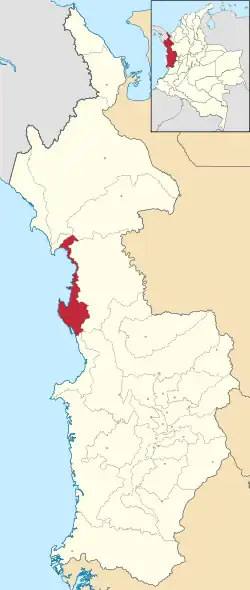
 Location of the municipality and town of Bahía Solano in the Choco Department of Colombia. | |
| Country | |
| Department | Chocó Department |
| Government | |
| • Mayor | Ulmer Mosquera Gutiérrez |
| Area | |
| • Municipality and town | 1,667 km2 (644 sq mi) |
| Elevation | 173 m (568 ft) |
| Population | |
| • Urban | 9.400 (2,017)[1] |
| Afro-Colombians, Embera Indians, Paisas | |
| Time zone | UTC-5 (Colombia Standard Time) |
| Website | www.bahiasolano-choco.gov.co |
Bahia is home to José Celestino Mutis Airport as well as seaport, and along with daily flights to and from Medellin, Quibdo, Cali, and Bogota, there are bi-weekly ships that take passengers and cargo from Bahia to the port of Buenaventura. The region around Bahia Solano is home to scuba diving and sport fishing opportunities, providing a plethora of marine activities to the traveller. 18 km away from Bahia Solano is the beach town of El Valle, Choco, which is the closest community to the Ensenada de Utria National Park, located only 9 kilometres (5.6 mi) down the beach.
Climate
Bahía Solano has a very wet tropical rainforest climate (Af).
| Climate data for Bahía Solano | |||||||||||||
|---|---|---|---|---|---|---|---|---|---|---|---|---|---|
| Month | Jan | Feb | Mar | Apr | May | Jun | Jul | Aug | Sep | Oct | Nov | Dec | Year |
| Average high °C (°F) | 29.4 (84.9) |
29.9 (85.8) |
29.9 (85.8) |
29.9 (85.8) |
29.7 (85.5) |
29.3 (84.7) |
29.5 (85.1) |
29.5 (85.1) |
29.1 (84.4) |
28.8 (83.8) |
28.7 (83.7) |
29.0 (84.2) |
29.4 (84.9) |
| Daily mean °C (°F) | 26.0 (78.8) |
26.3 (79.3) |
26.2 (79.2) |
26.1 (79.0) |
25.9 (78.6) |
25.7 (78.3) |
25.8 (78.4) |
25.8 (78.4) |
25.6 (78.1) |
25.6 (78.1) |
25.5 (77.9) |
25.7 (78.3) |
25.9 (78.5) |
| Average low °C (°F) | 22.5 (72.5) |
22.4 (72.3) |
22.4 (72.3) |
22.7 (72.9) |
23.7 (74.7) |
22.4 (72.3) |
22.3 (72.1) |
22.4 (72.3) |
22.2 (72.0) |
22.0 (71.6) |
22.0 (71.6) |
21.9 (71.4) |
22.4 (72.3) |
| Average rainfall mm (inches) | 273.9 (10.78) |
170.0 (6.69) |
195.0 (7.68) |
339.0 (13.35) |
482.5 (19.00) |
454.2 (17.88) |
475.0 (18.70) |
571.5 (22.50) |
565.0 (22.24) |
770.0 (30.31) |
639.8 (25.19) |
472.7 (18.61) |
5,408.6 (212.93) |
| Average rainy days | 18 | 12 | 13 | 21 | 24 | 24 | 24 | 24 | 25 | 25 | 24 | 22 | 256 |
| Average relative humidity (%) | 90 | 89 | 89 | 90 | 91 | 91 | 91 | 91 | 91 | 92 | 92 | 91 | 91 |
| Mean monthly sunshine hours | 77.5 | 87.5 | 86.8 | 69.0 | 62.0 | 57.0 | 77.5 | 71.3 | 51.0 | 58.9 | 48.0 | 49.6 | 796.1 |
| Mean daily sunshine hours | 2.5 | 3.1 | 2.8 | 2.3 | 2.0 | 1.9 | 2.5 | 2.3 | 1.7 | 1.9 | 1.6 | 1.6 | 2.2 |
| Source: [2] | |||||||||||||
References
- Bahía Solano · Población poblacion.population.city, retrieved 26 January 2020
- "Data". www.ideam.gov.co. Retrieved 2020-06-26.
Weblinks
- Alcaldía Municipal de Bahía Solano (Spanish)
- Website for Eco Tourism (English)