Bakhchysarai Raion
Bakhchysarai Raion (Russian: Бахчисарайский район; Ukrainian: Бахчисарайський район; Crimean Tatar: Bağçasaray rayonı) is one of the 25 regions of Crimea, currently subject to a territorial dispute between the Russian Federation and Ukraine. Population: 90,911 (2014 Census).[1]
Bakhchysarai Raion
Bağçasaray rayonı | |
|---|---|
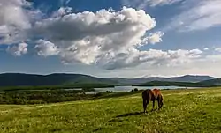 Baydarsky Reserve, Bakhchysarai District | |
 Flag  Seal | |
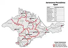
Raion location within Crimea | |
| Coordinates: 44°45′N 33°54′E | |
| Country | |
| Republic | Crimea |
| Admin. center | Bakhchysarai |
| Subdivisions | List
|
| Area | |
| • Total | 1,589 km2 (614 sq mi) |
| Population (2014) | |
| • Total | 90,911 |
| • Density | 57/km2 (150/sq mi) |
| Time zone | UTC+2 (EET) |
| • Summer (DST) | UTC+3 (EEST) |
| Dialing code | +380-6554 |
The Bakhchysarai Raion is situated in the southwestern part of the peninsula. Two thirds of the raion's area is mountainous, while the northwestern part of the region is occupied by the coastal plain.
Places of interest
The raion contains a great number of historical landmarks of the ancient history and the Middle Ages history of Crimea, among which are so called cave cities Chufut-Kale, Mangup, and others. The administrative centre of the raion, Bakhchysarai, in the past was a capital of the Crimean Khanate. In addition, the Crimean Astrophysical Observatory is located in the town of Nauchniy.
A few other important attractions located within the raion:
- Bakhchisaray Palace
- The "cave city" of Çufut Qale
- The "cave city" of Eski Kermen
- Mangup
- The "cave city" of Tepe Kermen
- Uspensky Cave Monastery[2]
2020 Ukrainian Administrative Reform
In July 2020, Ukraine conducted an administrative reform throughout its de jure territory. This included Crimea, which was at the time occupied by Russia, and is still ongoing as of October 2023. Crimea was reorganized from 14 raions and 11 municipalities into 10 raions, with municipalities abolished altogether. The territory of Bakhchysarai Raion was expanded to include parts of Sevastopol, but has not yet been implemented due to the ongoing Russian occupation.[3]
Footnotes and references
- Russian Federal State Statistics Service (2014). "Таблица 1.3. Численность населения Крымского федерального округа, городских округов, муниципальных районов, городских и сельских поселений" [Table 1.3. Population of Crimean Federal District, Its Urban Okrugs, Municipal Districts, Urban and Rural Settlements]. Федеральное статистическое наблюдение «Перепись населения в Крымском федеральном округе». ("Population Census in Crimean Federal District" Federal Statistical Examination) (in Russian). Federal State Statistics Service. Retrieved January 4, 2016.
- "Bakhchisaray historical and cultural preserve". Archived from the original on 2013-03-29. Retrieved 2012-11-26.
- "Про утворення та ліквідацію районів". Офіційний вебпортал парламенту України (in Ukrainian). Retrieved 2023-10-16.
External links
Places adjacent to Bakhchysarai Raion | |
|---|---|
| Cities | Coat of arms of Bakhchysarai Raion | |
|---|---|---|
| Urban-type settlements | ||
| Villages |
| |
| Raions | |||||
|---|---|---|---|---|---|
| Municipalities | |||||
| Cities |
| ||||
| |||||
| Raions |  | |
|---|---|---|
| Cities and Urban-type settlements under the hromadas | ||
1Due to continued occupation, not yet implemented | ||