Kirovske Raion
Kirovske Raion (Russian: Кировский район), known by Ukrainian authorities[nb 1] as the İslâm Terek Raion (Ukrainian: Іслямтерецький район, Crimean Tatar: İslâm Terek rayonı) is one of the 25 regions of Crimea, currently subject to a territorial dispute between the Russian Federation and Ukraine. The raion's administrative centre is the urban-type settlement of Kirovske. Population: 50,834 (2014 Census).[1]
Kirovske Raion
İslâm Terek rayonı | |
|---|---|
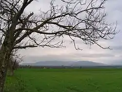
 Agarmysh, Kirovsky District | |
 Flag  Seal | |
Raion location within Crimea | |
| Country | |
| Republic | Crimea |
| Capital | Kirovske |
| Subdivisions | List
|
| Area | |
| • Total | 1,208 km2 (466 sq mi) |
| Population (2014) | |
| • Total | 50,834 |
| • Density | 42/km2 (110/sq mi) |
| Time zone | UTC+3 (MSK) |
| Dialing code | +380-6555 |
| Website | kirovskiy |
The raion is located in eastern Crimea. The geography of the raion is divided between the foothills in the south, while the north forms part of the Crimean steppe. The main waterway of the northern peninsula, the North Crimean Canal supplying water from the Dnieper river, passes through the raion.
The raion is famous for the historical town of Stary Krym.
Notes
- The renaming has been effected by Ukraine's decommunization laws, but as Crimea is outside of Ukrainian control, this decision has had little practical effect.
References
- Russian Federal State Statistics Service (2014). "Таблица 1.3. Численность населения Крымского федерального округа, городских округов, муниципальных районов, городских и сельских поселений" [Table 1.3. Population of Crimean Federal District, Its Urban Okrugs, Municipal Districts, Urban and Rural Settlements]. Федеральное статистическое наблюдение «Перепись населения в Крымском федеральном округе». ("Population Census in Crimean Federal District" Federal Statistical Examination) (in Russian). Federal State Statistics Service. Retrieved January 4, 2016.
