Mooroobool, Queensland
Mooroobool is a suburb of Cairns in the Cairns Region, Queensland, Australia.[2] In the 2016 census, Mooroobool had a population of 7,222 people.[1]
| Mooroobool Cairns, Queensland | |||||||||||||||
|---|---|---|---|---|---|---|---|---|---|---|---|---|---|---|---|
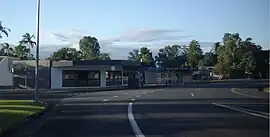
 Carnation Drive and Primrose Street | |||||||||||||||
 Mooroobool | |||||||||||||||
| Coordinates | 16.9361°S 145.7297°E | ||||||||||||||
| Population | 7,222 (2016 census)[1] | ||||||||||||||
| • Density | 1,570/km2 (4,070/sq mi) | ||||||||||||||
| Postcode(s) | 4870 | ||||||||||||||
| Area | 4.6 km2 (1.8 sq mi) | ||||||||||||||
| Time zone | AEST (UTC+10:00) | ||||||||||||||
| LGA(s) | Cairns Region | ||||||||||||||
| State electorate(s) | Cairns | ||||||||||||||
| Federal division(s) | Leichhardt | ||||||||||||||
| |||||||||||||||
Geography
Mooroobool is located 5.4 kilometres (3.4 mi) west of the Cairns central business district.
Mooroobool has a mixture of dwellings which are mainly residential and commercial properties. Nearby suburbs are Earlville and Kanimbla.
History
Mooroobool is situated in the Yidinji traditional Aboriginal country. [3] The suburb was named by the Queensland Place Names Board on 1 September 1973.[2] The origin of the suburb name is from the geographical feature Mooroobool Peak located west from the suburb, named from an Aboriginal word meaning 'meeting of the waters'. [4]
Kingsford Street is named after Richard Ash Kingsford, who was mayor of Cairns from 1885-1886 and in 1889.[5]
Balaclava State School opened on 2 February 1954.[6]
At the 2006 census, Mooroobool had a population of 6,618.[7]
In the 2016 census, Mooroobool had a population of 7,222 people.[1]
Amenities
Mooroobool has a Campbell’s Super IGA and a police beat.
Education
Balaclava State School is a government primary (Prep-6) school for boys and girls at 418 Mulgrave Road (16.9367°S 145.7449°E).[8][9] In 2017, the school had an enrolment of 353 students with 31 teachers (29 full-time equivalent) and 26 non-teaching staff (17 full-time equivalent).[10] The school was a special education program.[8]
References
- Australian Bureau of Statistics (27 June 2017). "Mooroobool (SSC)". 2016 Census QuickStats. Retrieved 20 October 2018.
- "Mooroobool – suburb in Cairns Region (entry 48772)". Queensland Place Names. Queensland Government. Retrieved 26 January 2020.
- "First people cultural history". Cairns Regional Council. Retrieved 23 June 2020.
- "M Suburbs" (PDF). Cairns Regional Council. Retrieved 23 June 2020.
- "Mayors of Cairns 1885 to Present" (PDF). Cairns Heritage Page. Cairns Regional Council. Retrieved 2 April 2014.
- Queensland Family History Society (2010), Queensland schools past and present (Version 1.01 ed.), Queensland Family History Society, ISBN 978-1-921171-26-0
- Australian Bureau of Statistics (25 October 2007). "Mooroobool (Cairns City) (State Suburb)". 2006 Census QuickStats. Retrieved 13 June 2011.
- "State and non-state school details". Queensland Government. 9 July 2018. Archived from the original on 21 November 2018. Retrieved 21 November 2018.
- "Balaclava State School". Retrieved 21 November 2018.
- "ACARA School Profile 2017". Archived from the original on 22 November 2018. Retrieved 22 November 2018.
External links
- "Cairns Suburbs". Queensland Places. University of Queensland.