Baode County
Baode (Chinese: 保德; pinyin: Bǎodé) is a county in the northwest of Shanxi province, China, bordering Shaanxi province to the west. It is under the administration of Xinzhou city, and is its westernmost county-level division.
Baode County
保德县 Paoteh | |
|---|---|
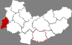 Location in Xinzhou | |
 Baode Location of the seat in Shanxi | |
| Coordinates: 39°01′24″N 111°05′15″E | |
| Country | People's Republic of China |
| Province | Shanxi |
| Prefecture-level city | Xinzhou |
| Area | |
| • County | 997.5 km2 (385.1 sq mi) |
| Population (2020) | 165,800 |
| • Rural | 136,200 |
| Time zone | UTC+8 (China Standard) |
| Postal code | 034000[1] |
| Area code | 0350[1] |
| Website | www |
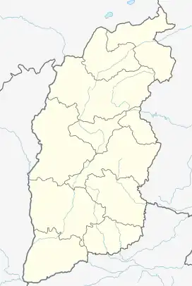
Administrative divisions
Baode administers 4 towns and 9 townships:[3]
Towns
- Dongguan (东关镇)
- Yimen (义门镇)
- Qiaotou (桥头镇)
- Yangjiawan (杨家湾镇)
Townships
- Yaozhuang (腰庄乡)
- Hanjiachuan (韩家川乡
- Linzheyu (林遮峪乡)
- Fengjiachuan (冯家川乡)
- Tuyata (土崖塔乡)
- Kongjiagou (孙家沟乡)
- Yaowa 窑洼乡
- Yaogetai (尧圪台乡)
- Nanhegou (南河沟乡)
Climate
| Climate data for Baode (1991–2020 normals, extremes 1981–2010) | |||||||||||||
|---|---|---|---|---|---|---|---|---|---|---|---|---|---|
| Month | Jan | Feb | Mar | Apr | May | Jun | Jul | Aug | Sep | Oct | Nov | Dec | Year |
| Record high °C (°F) | 10.3 (50.5) |
19.6 (67.3) |
28.4 (83.1) |
36.1 (97.0) |
36.2 (97.2) |
40.9 (105.6) |
41.5 (106.7) |
38.7 (101.7) |
37.0 (98.6) |
29.2 (84.6) |
22.4 (72.3) |
14.4 (57.9) |
41.5 (106.7) |
| Average high °C (°F) | −0.9 (30.4) |
4.8 (40.6) |
12.4 (54.3) |
20.4 (68.7) |
26.3 (79.3) |
30.5 (86.9) |
31.7 (89.1) |
29.3 (84.7) |
24.3 (75.7) |
17.4 (63.3) |
8.6 (47.5) |
0.8 (33.4) |
17.1 (62.8) |
| Daily mean °C (°F) | −7.7 (18.1) |
−2.5 (27.5) |
4.9 (40.8) |
12.8 (55.0) |
18.9 (66.0) |
23.4 (74.1) |
25.1 (77.2) |
22.9 (73.2) |
17.4 (63.3) |
10.3 (50.5) |
2.0 (35.6) |
−5.5 (22.1) |
10.2 (50.3) |
| Average low °C (°F) | −12.7 (9.1) |
−8.1 (17.4) |
−1.2 (29.8) |
6.0 (42.8) |
12.1 (53.8) |
17.1 (62.8) |
19.6 (67.3) |
17.8 (64.0) |
12.2 (54.0) |
5.0 (41.0) |
−2.7 (27.1) |
−10.1 (13.8) |
4.6 (40.2) |
| Record low °C (°F) | −23.9 (−11.0) |
−20.8 (−5.4) |
−15.7 (3.7) |
−5.4 (22.3) |
1.3 (34.3) |
5.8 (42.4) |
12.7 (54.9) |
9.1 (48.4) |
1.7 (35.1) |
−6.5 (20.3) |
−17.5 (0.5) |
−25.8 (−14.4) |
−25.8 (−14.4) |
| Average precipitation mm (inches) | 2.7 (0.11) |
3.3 (0.13) |
8.3 (0.33) |
16.6 (0.65) |
34.9 (1.37) |
48.1 (1.89) |
112.6 (4.43) |
103.1 (4.06) |
59.6 (2.35) |
24.2 (0.95) |
10.8 (0.43) |
2.2 (0.09) |
426.4 (16.79) |
| Average precipitation days (≥ 0.1 mm) | 2.1 | 2.5 | 3.3 | 4.2 | 6.7 | 8.6 | 11.5 | 10.7 | 9.3 | 5.9 | 3.2 | 1.9 | 69.9 |
| Average snowy days | 2.9 | 3.3 | 1.6 | 0.4 | 0 | 0 | 0 | 0 | 0 | 0.3 | 1.7 | 2.4 | 12.6 |
| Average relative humidity (%) | 56 | 49 | 40 | 36 | 38 | 47 | 59 | 66 | 66 | 61 | 58 | 56 | 53 |
| Mean monthly sunshine hours | 153.3 | 175.5 | 213.3 | 236.9 | 264.3 | 249.9 | 241.0 | 222.2 | 200.8 | 202.2 | 162.9 | 147.4 | 2,469.7 |
| Percent possible sunshine | 50 | 57 | 57 | 59 | 59 | 56 | 54 | 53 | 55 | 59 | 55 | 50 | 55 |
| Source: China Meteorological Administration[4][5] | |||||||||||||
References
- "山西省忻州市保德县地名介绍".
- "保德红枣-山西忻州". Archived from the original on 2018-12-31.
- "2020年统计用区划代码". www.stats.gov.cn. Retrieved 2021-10-18.
- 中国气象数据网 – WeatherBk Data (in Simplified Chinese). China Meteorological Administration. Retrieved 26 August 2023.
- 中国气象数据网 (in Simplified Chinese). China Meteorological Administration. Retrieved 26 August 2023.
- www.xzqh.org (in Chinese)
This article is issued from Wikipedia. The text is licensed under Creative Commons - Attribution - Sharealike. Additional terms may apply for the media files.