Barahapokhari Rural Municipality
Barahapokhari (Nepali: वराहपोखरी गाउँपालिका) is a rural municipality (gaunpalika) out of eight rural municipality located in Khotang District of Province No. 1 of Nepal. There are a total of 10 municipalities in Khotang in which 2 are urban and 8 are rural.
Barahapokhari
वराहपोखरी गाउँपालिका | |
|---|---|
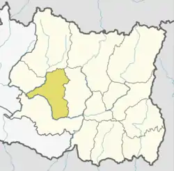
 Barahapokhari Location in Province No. 1  Barahapokhari Barahapokhari (Nepal) | |
| Coordinates: 26.95°N 86.82°E | |
| Province | Province No. 1 |
| District | Khotang |
| Wards | 6 |
| Established | 10 March 2017 |
| Seat | Baghkhor Bhanjyang |
| Government | |
| • Type | Rural Council |
| • Chairperson | Mr. Shalikram Banjara (NC) |
| • Vice-chairperson | Mr.Bhuwalraj Rai (NCP US) |
| • Provincial constituency | Khotang 1 (B) |
| Area | |
| • Total | 141.6 km2 (54.7 sq mi) |
| Population (2011) | |
| • Total | 14,349 |
| • Density | 100/km2 (260/sq mi) |
| Time zone | UTC+5:45 (Nepal Standard Time) |
| Website | official website |
According to Ministry of Federal Affairs and Local Developme Barahapokhari has an area of 141.6 square kilometres (54.7 sq mi) and the total population of the municipality is 14349 as of Census of Nepal 2011.[1][2]
Pauwasera, Phaktang, Barahapokhari, Mauwabote, Saunechaur and Suntale which previously were all separate Village development committee merged to form this new local level body. Fulfilling the requirement of the new Constitution of Nepal 2015, Ministry of Federal Affairs and Local Development replaced all old VDCs and Municipalities into 753 new local level body (Municipality).[1]
Ward divisions
The rural municipality is divided into total 6 wards and the headquarter of this newly formed rural municipality is situated in Saunechaur.[1]
| Ward No. | Ward Name | Area (km2) | Pop. (2011) |
|---|---|---|---|
| 1 | Barahapokhari | 36.43 | 3830 |
| 2 | Suntale | 27.29 | 2995 |
| 3 | Saunechaur | 13.21 | 2383 |
| 4 | Phaktang | 23.83 | 2176 |
| 5 | Pauwasera | 28.78 | 2355 |
| 6 | Mauwabote | 12.51 | 1410 |
References
- "स्थानीय तहहरुको विवरण". www.mofald.gov.np/en. MoFALD. Archived from the original on 31 August 2018. Retrieved 18 April 2018.
- "CITY POPULATION – statistics, maps & charts". www.citypopulation.de. 8 October 2017. Retrieved 18 April 2018.