Bascom station
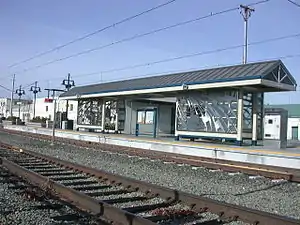
Bascom station is a light rail station operated by Santa Clara Valley Transportation Authority (VTA). The station has a single center platform between two tracks. Bascom station is served by the Green Line of the VTA Light Rail system.
Bascom | |||||||||||
|---|---|---|---|---|---|---|---|---|---|---|---|
 Bascom station platform, 2006 | |||||||||||
| General information | |||||||||||
| Location | 2051 Southwest Expressway San Jose, California | ||||||||||
| Coordinates | 37°17′59″N 121°55′48″W | ||||||||||
| Owned by | Santa Clara Valley Transportation Authority | ||||||||||
| Platforms | 1 island platform | ||||||||||
| Tracks | 2 | ||||||||||
| Connections | |||||||||||
| Construction | |||||||||||
| Parking | 102 spaces | ||||||||||
| Accessible | Yes | ||||||||||
| History | |||||||||||
| Opened | October 1, 2005[2] | ||||||||||
| Services | |||||||||||
| |||||||||||
| Location | |||||||||||
Location
Bascom station is located along the Southwest Expressway near the intersection of Bascom Avenue, after which the station was named. The Los Gatos Creek Trail trailhead is located about a block away from the station.
History
Bascom station was built as part of the Vasona Light Rail extension project. This project extended VTA light rail service from the intersection of Woz Way and West San Carlos St in San Jose in a southwesterly direction to the Winchester station in western Campbell.[3]
The official opening date for this station was October 1, 2005.
The construction of this station and the rest of the Vasona Light Rail extension was part of the 1996 Measure B Transportation Improvement Program. Santa Clara County voters approved the Measure B project in 1996 along with a one half percent sales tax increase. The Vasona Light Rail extension was funded mostly by the resulting sales tax revenues with additional money coming from federal and state funding, grants, VTA bond revenues, and municipal contributions.[4]
Screens

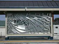
San Jose artist Diana Pumpelly Bates has created metal screens for the shelters that provide visual interest for passengers at the stations as well as for motorists and pedestrians passing by the stations. The patterns are a reminder of woven baskets created by the valley's early inhabitants.[5]
Service
Station layout
| Freight line | ← Union Pacific branch line; No passenger service → | |
| Light rail | Northbound | ← |
| Island platform, doors will open on the left | ||
| Southbound | | |
References
- "VTA Light Rail System" (PDF). Santa Clara Valley Transportation Authority. June 13, 2022. Retrieved October 11, 2022.
- "VTA Facts: Light Rail System" (PDF). Santa Clara Valley Transportation Authority. November 30, 2006. Archived from the original (PDF) on March 20, 2009. Retrieved January 10, 2020.
- "Vasona Project Description". Completed projects. Santa Clara Valley Transportation Authority. 2008-09-15. Archived from the original on 2011-06-05. Retrieved 2008-11-16.
- "Making the Light Rail Connection: Expanded Service Adds 5.3 miles to System". Santa Clara Valley Transportation Authority. 2005-10-01. Archived from the original on 2007-09-30. Retrieved 2008-11-16.
- "Bascom Station". Vasona Light Rail Extension. Santa Clara Valley Transportation Authority. 2008-05-12. Archived from the original on 29 October 2008. Retrieved 2008-11-16.