Bayswater, New Zealand
Bayswater is a suburb located on the North Shore of Auckland, New Zealand. It lies on a peninsula which juts into the Waitemata Harbour. Politically the suburb is part of the Devonport-Takapuna Local Board and the North Shore ward of Auckland Council.[3]
Bayswater | |
|---|---|
 Bayswater marina with Takapuna in the background | |
| Coordinates: 36.815°S 174.773°E | |
| Country | New Zealand |
| City | Auckland |
| Local authority | Auckland Council |
| Electoral ward | North Shore ward |
| Local board | Devonport-Takapuna Local Board |
| Established | 1850s (Approx.) |
| Area | |
| • Land | 110 ha (270 acres) |
| Population (June 2023)[2] | |
| • Total | 2,760 |
| Postcode(s) | 0622 |
| Ferry terminal(s) | Bayswater wharf |
| (Waitemata Harbour) | (Waitemata Harbour) | Belmont |
| (Waitemata Harbour) |
|
Narrow Neck |
| (Waitemata Harbour) | (Waitemata Harbour) | (Waitemata Harbour) |
Demographics
Bayswater covers 1.10 km2 (0.42 sq mi)[1] and had an estimated population of 2,760 as of June 2023,[2] with a population density of 2,509 people per km2.
| Year | Pop. | ±% p.a. |
|---|---|---|
| 2006 | 2,643 | — |
| 2013 | 2,823 | +0.95% |
| 2018 | 2,865 | +0.30% |
| Source: [4] | ||
Bayswater had a population of 2,865 at the 2018 New Zealand census, an increase of 42 people (1.5%) since the 2013 census, and an increase of 222 people (8.4%) since the 2006 census. There were 1,038 households, comprising 1,365 males and 1,503 females, giving a sex ratio of 0.91 males per female. The median age was 37.1 years (compared with 37.4 years nationally), with 564 people (19.7%) aged under 15 years, 669 (23.4%) aged 15 to 29, 1,281 (44.7%) aged 30 to 64, and 354 (12.4%) aged 65 or older.
Ethnicities were 80.6% European/Pākehā, 11.7% Māori, 6.3% Pacific peoples, 10.3% Asian, and 3.8% other ethnicities. People may identify with more than one ethnicity.
The percentage of people born overseas was 32.5, compared with 27.1% nationally.
Although some people chose not to answer the census's question about religious affiliation, 54.6% had no religion, 32.9% were Christian, 0.3% had Māori religious beliefs, 0.5% were Hindu, 0.7% were Muslim, 1.0% were Buddhist and 2.3% had other religions.
Of those at least 15 years old, 783 (34.0%) people had a bachelor's or higher degree, and 222 (9.6%) people had no formal qualifications. The median income was $43,000, compared with $31,800 nationally. 684 people (29.7%) earned over $70,000 compared to 17.2% nationally. The employment status of those at least 15 was that 1,257 (54.6%) people were employed full-time, 315 (13.7%) were part-time, and 72 (3.1%) were unemployed. [4]
History
Bayswater was originally named O'Neill's Point after the first European settlers in the area, brothers Allan and James O'Neill.[5] Originally settling at the point (which still bears their name) at the end of the peninsula in the 1840s, by the 1850s[6] the O'Neills owned the entire peninsula. Sometime later the area was renamed Bayswater after one of the more expensive new inner suburbs of London. The London Bayswater is located north of Hyde Park and was developed during the middle of the 19th century. The name was chosen for the Auckland suburb to evoke a sense of style as well as being a straight description of its physical location as a seaside development.
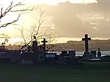
O'Neill's Point Cemetery
O'Neill’s Point Cemetery is located at 122 Bayswater Avenue. It was opened in 1891 and named after Alan and James O'Neill. The cemetery contains the official war graves of 41 men who served in the New Zealand forces and one man who served with the UK forces during World War I and who died before September 1, 1921. A number of World War I graves (returned soldiers and soldiers who died of the flu and other causes at the nearby Narrow Neck army camp) can be found here.[7]
Shoal Bay
Education
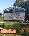
Bayswater School is a coeducational contributing primary (years 1–6) school with a roll of 135 as of April 2023.[8][9] The school celebrated its 50th Jubilee in 2003.[10] Yachtsman Peter Blake was an alumnus of the school.[11]
References
- "ArcGIS Web Application". statsnz.maps.arcgis.com. Retrieved 2 July 2022.
- "Population estimate tables - NZ.Stat". Statistics New Zealand. Retrieved 25 October 2023.
- Council, Auckland. "Auckland Council explained". Auckland Council. Retrieved 15 December 2021.
- "Statistical area 1 dataset for 2018 Census". Statistics New Zealand. March 2020. Bayswater (129400). 2018 Census place summary: Bayswater
- Wises New Zealand Guide, 7th Edition, 1979. p. 316
- Wises New Zealand Guide, 7th Edition, 1979. p. 29
- "O'Neill's Point Cemetery". Welcome to Heritage New Zealand. 7 July 2022. Retrieved 18 April 2023.
- "New Zealand Schools Directory". New Zealand Ministry of Education. Retrieved 12 December 2022.
- Education Counts: Bayswater School
- "Bayswater School 50th Jubilee Reunion". Education Gazette New Zealand. 82 (16). 1 September 2003.
- "Blake, PeterJames". Teara.govt.nz. 3 April 2023. Retrieved 3 April 2023.
External links
- Bayswater School website
- Photographs of Bayswater held in Auckland Libraries' heritage collections.