Beak Island
Beak Island is an arc-shaped island, 7 kilometres (4 nmi) long and 360 metres (1,200 ft) high, lying 1 kilometre (0.5 nmi) northeast of Eagle Island in the northeast part of Prince Gustav Channel. It was probably first seen in 1902–03 by members of the Swedish Antarctic Expedition under Otto Nordenskiöld. The Falkland Islands Dependencies Survey surveyed Beak Island in 1945 and so named it because of its shape and relative position to nearby Tail Island and Eagle Island.[1]
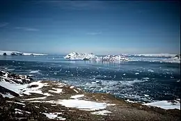 View of Beak Island from western summit of View Point | |
 Beak Island Location in Antarctica | |
| Geography | |
|---|---|
| Location | Antarctica |
| Coordinates | 63°37′S 57°18′W |
| Highest elevation | 360 m (1180 ft) |
| Administration | |
| Administered under the Antarctic Treaty System | |
| Demographics | |
| Population | Uninhabited |
Bear Island is volcanic in origin, having been K-Ar dated 1.7 ± 0.2 and 2.0 ± 0.2 million years old. It forms part of the James Ross Island Volcanic Group.[2]
References
- "Beak Island". Geographic Names Information System. United States Geological Survey, United States Department of the Interior. Retrieved 25 May 2011.
- "Geological Map of James Ross Island" (PDF). Retrieved 23 March 2020.
![]() This article incorporates public domain material from "Beak Island". Geographic Names Information System. United States Geological Survey.
This article incorporates public domain material from "Beak Island". Geographic Names Information System. United States Geological Survey.