Beechmont, Muhlenberg County, Kentucky
Beechmont is a census-designated place and unincorporated community in Muhlenberg County, Kentucky, United States. As of the 2020 census, the population was 776,[2] up from 689 in 2010.
Beechmont, Kentucky | |
|---|---|
 Beechmont  Beechmont | |
| Coordinates: 37°10′28″N 87°1′57″W | |
| Country | United States |
| State | Kentucky |
| County | Muhlenberg |
| Area | |
| • Total | 1.82 sq mi (4.73 km2) |
| • Land | 1.82 sq mi (4.71 km2) |
| • Water | 0.01 sq mi (0.02 km2) |
| Elevation | 463 ft (141 m) |
| Population | |
| • Total | 776 |
| • Density | 426.61/sq mi (164.72/km2) |
| Time zone | UTC-6 (Central (CST)) |
| • Summer (DST) | UTC-5 (CST) |
| ZIP code | 42323 |
| Area code | 270 |
| FIPS code | 21-05014 |
| GNIS feature ID | 486750[3] |
Geography
Beechmont is in southeastern Muhlenberg County, along U.S. Route 431, which leads north 3.5 miles (5.6 km) to Drakesboro and south 7 miles (11 km) to Dunmor. Greenville, the county seat, is 9 miles (14 km) to the northwest.
According to the U.S. Census Bureau, the Beechmont CDP has a total area of 1.83 square miles (4.7 km2), of which 0.006 square miles (0.016 km2), or 0.33%, are water.[1] The town drains west to Beech Creek, south to Hazel Creek, east to Little Hazel Creek, and north to Plum Creek, all of which are within the Green River watershed.
References
- "2022 U.S. Gazetteer Files: Kentucky". United States Census Bureau. Retrieved May 23, 2023.
- "P1. Race – Beechmont CDP, Kentucky: 2020 DEC Redistricting Data (PL 94-171)". U.S. Census Bureau. Retrieved May 23, 2023.
- U.S. Geological Survey Geographic Names Information System: Beechmont, Muhlenberg County, Kentucky
- "Census of Population and Housing". Census.gov. Retrieved June 4, 2016.
Municipalities and communities of Muhlenberg County, Kentucky, United States | ||
|---|---|---|
| Cities | 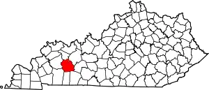 Location of Muhlenberg County, Kentucky | |
| CDPs | ||
| Other communities | ||
| Ghost town | ||
| Footnotes | ‡This populated place also has portions in an adjacent county or counties | |
This article is issued from Wikipedia. The text is licensed under Creative Commons - Attribution - Sharealike. Additional terms may apply for the media files.