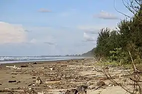
Belait Beach
Belait Beach (Malay: Pantai Belait),[1] also known as Kuala Belait Beach (Malay: Pantai Kuala Belait),[2] is a beach in Kuala Belait, Mukim Kuala Belait, Belait District, Brunei.[3] The beach used to stretch from Kuala Belait to Pelumpong Spit but was cut and split at Muara Beach.[4]
| Belait Beach | |
|---|---|
| Pantai Belait | |
 | |
 | |
| Location | Kuala Belait, Kuala Belait, Belait |
| Nearest city | Bandar Seri Begawan, Brunei-Muara |
| Coordinates | 4.5921880°N 114.2121968°E |
| Governing body | Kuala Belait and Seria Municipal Department |
Offshore platforms from the South West Ampa Field can also be seen in distance from the beach.[5] Seawalls have been built along the coastline in order to reduce erosion.[6] Activities such as surf fishing do take place on the beach.[7]
History
In 1930, British Malayan Petroleum Company (BMPC) constructed a telephone line along the Belait coastline which linked up Seria and Rasau.[8] As of 1934, the beach was used as a highway between the town and Tutong District.[9] In which a ferry would take passengers across the Tutong River separating the two districts.[10]
At midnight on December 16, 1941,[11] an amphibious assault was carried out by 10,000 soldiers from the Japanese Kawaguchi Detachment at Belait Beach as part of the Japanese occupation of British Borneo during World War II.[12][13]
From 2001 to 2005, the Eighth National Development Plan (RKN 8) aimed to build a car park and dumping ground within two separate plans.[14] On February 2, 2020, a company was issued a penalty for illegal dumping on the beach.[15]
References
- Dari "Pemburu" ke "Terapeutik": antologi cerpen Mastera (in Malay). Pusat Bahasa, Departemen Pendidikan Nasional. 2005. p. 127. ISBN 978-979-685-480-6.
- Brunei (1958). Penyata pembangunan Negeri Brunei 1953-1958 (in Malay). p. 69.
- Brunei, Muzium (1994). Brunei Museum journal. The Museum. p. 55.
- Silvestre, Geronimo (1992). The Coastal Resources of Brunei Darussalam: Status, Utilization and Management. WorldFish. p. 141. ISBN 978-971-8709-11-5.
- activ8bn. "5 spectacular sunset spots around Brunei". Brunei Tourism. Retrieved 2022-06-27.
- Chua, Thia-Eng; Chou, L. M.; Sadorra, Marie Sol M. (1987). The Coastal Environmental Profile of Brunei Darussalam: Resource Assessment and Management Issues. WorldFish. p. 59. ISBN 978-971-10-2237-2.
- "Riding on the wave of surfcasting » Borneo Bulletin Online". Riding on the wave of surfcasting. 2021-06-23. Retrieved 2022-06-27.
- Office, Great Britain Colonial (1930). Colonial Reports - Annual. H.M. Stationery Office. p. 12.
- Saunders, Graham (2013-11-05). A History of Brunei. Routledge. p. 119. ISBN 978-1-136-87394-2.
- Colonial Reports--annual. H.M. Stationery Office. 1934. p. 25.
- Halim, Yura (2002). Ririsej Brunei Darussalam (in Malay). Dewan Bahasa dan Pustaka Brunei, Kementerian Kebudayaan, Belia dan Sukan. p. 40. ISBN 978-99917-0-251-3.
- Saunders, Graham (2013-11-05). A History of Brunei. Routledge. p. 121. ISBN 978-1-136-87394-2.
- Gin, Ooi Keat (2010-12-17). The Japanese Occupation of Borneo, 1941-45. Routledge. ISBN 978-1-136-96309-4.
- Brunei (2000). Eighth National Development Plan, 2001-2005. Government Print. Department. p. 212.
- "Local company fined for littering » Borneo Bulletin Online". Local company fined for littering. 2020-02-02. Retrieved 2022-06-27.