Bendena, Kansas
Bendena is an unincorporated community in Doniphan County, Kansas, United States.[1] As of the 2020 census, the population of the community and nearby areas was 117.[2]
Bendena, Kansas | |
|---|---|
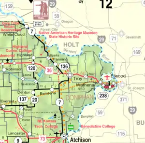 KDOT map of Doniphan County (legend) | |
 Bendena  Bendena | |
| Coordinates: 39°44′28″N 95°10′46″W[1] | |
| Country | United States |
| State | Kansas |
| County | Doniphan |
| Founded | 1886 |
| Area | |
| • Total | 1.53 sq mi (3.96 km2) |
| • Land | 1.53 sq mi (3.96 km2) |
| • Water | 0.0 sq mi (0.0 km2) |
| Elevation | 1,112 ft (339 m) |
| Population | |
| • Total | 117 |
| • Density | 77/sq mi (30/km2) |
| Time zone | UTC-6 (CST) |
| • Summer (DST) | UTC-5 (CDT) |
| ZIP code | 66008 |
| Area code | 785 |
| FIPS code | 20-05975 |
| GNIS ID | 473280 [1] |
History
Bendena was founded in 1886.[3] It was originally given the name of Albers, after John Albers, who farmed on this land. But when the United States Postal Service established a post office there, they required a change of name because of similarities to other town names in Kansas. It was then named for the sweetheart of the first telegraph operator at the Chicago, Kansas and Nebraska railroad station.[4]
The first post office in Bendena was established in January, 1888.[5] Its ZIP Code is 66008.[6]
Geography
Bendena is located southwest of the center of Doniphan County, along highway K-20. It is 7 miles (11 km) southwest of Troy, the county seat, and 15 miles (24 km) north of Atchison.
According to the U.S. Census Bureau, the Bendena CDP has an area of 1.53 square miles (3.96 km2), all of it land.
Demographics
| Census | Pop. | Note | %± |
|---|---|---|---|
| 2010 | 117 | — | |
| 2020 | 117 | 0.0% | |
| U.S. Decennial Census | |||
For statistical purposes, the United States Census Bureau has defined Bendena as a census-designated place (CDP).
The community is part of the St. Joseph, MO–KS Metropolitan Statistical Area.
Education
The community is served by Doniphan West USD 111 public school district.
References
- "Bendena, Kansas", Geographic Names Information System, United States Geological Survey, United States Department of the Interior
- "Profile of Bendena, Kansas (CDP) in 2020". United States Census Bureau. Archived from the original on June 26, 2022. Retrieved June 26, 2022.
- Blackmar, Frank Wilson (1912). Kansas: A Cyclopedia of State History, Embracing Events, Institutions, Industries, Counties, Cities, Towns, Prominent Persons, Etc. Standard Publishing Company. pp. 172.
- Gray, Patrick Leopoldo (1905). Gray's Doniphan County History: A Record of the Happenings of Half a Hundred Years. Roycroft Press. pp. 56.
- "Kansas Post Offices, 1828-1961 (archived)". Kansas Historical Society. Archived from the original on October 9, 2013. Retrieved June 8, 2014.
- United States Postal Service (2012). "USPS - Look Up a ZIP Code". Retrieved February 15, 2012.
Further reading
External links
Municipalities and communities of Doniphan County, Kansas, United States | ||
|---|---|---|
| Cities | 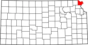 Map of Kansas highlighting Doniphan County | |
| Unincorporated communities | ||
| Ghost town | ||
| Indian reservation | ||
| Townships | ||
| Footnotes | †This community is designated a Census-Designated Place (CDP) by the United States Census Bureau. ‡This community also has portions in an adjacent county or counties. | |