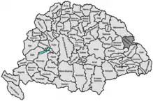
Beszterce-Naszód County
Beszterce-Naszód was an administrative county (comitatus) of the Kingdom of Hungary. Its territory is now in northern Romania (north-eastern Transylvania). The capital of the county was Beszterce (now Bistrița).
| Beszterce-Naszód County | |
|---|---|
| County of the Kingdom of Hungary (1876-1920, 1940-1945) | |
 Coat of arms
| |
 | |
| Capital | Beszterce |
| Area | |
| • Coordinates | 47°8′N 24°30′E |
• 1910 | 4,167 km2 (1,609 sq mi) |
| Population | |
• 1910 | 127800 |
| History | |
| History | |
• Established | 1876 |
| 4 June 1920 | |
• County recreated (Second Vienna Award) | 30 August 1940 |
• Disestablished | 1945 |
| Today part of | Romania |
| Bistrița is the current name of the capital. | |
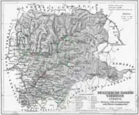
Geography

Beszterce-Naszód county shared borders with the Kingdom of Romania, Austrian Bukovina and the Hungarian counties of Máramaros, Szolnok-Doboka, Kolozs, Maros-Torda and Csík. Its area was 4,167 km² around 1910.
History
Beszterce-Naszód county was formed in 1876, when the Saxon district of Bistritz/Bistrița was united with the former Transylvanian Military Frontier district of Năsăud (Romanian Border Regiment II), also joined by parts of the former Doboka and Belső-Szolnok counties. In 1920, the Treaty of Trianon assigned the territory of Beszterce-Naszód county to Romania. In 1940, by the Second Vienna Award, it was returned to Hungary and was expanded with additional territories from the former Kolozs County. After World War II, it became again part of Romania; the territory of the county is now in the (larger) Romanian county Bistrița-Năsăud.
Demographics
| Census | Total | Romanian | German | Hungarian | Other or unknown |
|---|---|---|---|---|---|
| 1880[1] | 95,017 | 62,048 (67.47%) | 23,113 (25.13%) | 3,540 (3.85%) | 3,260 (3.54%) |
| 1890[2] | 104,737 | 70,466 (67.28%) | 25,268 (24.13%) | 4,994 (4.77%) | 4,009 (3.83%) |
| 1900[3] | 119,014 | 82,256 (69.11%) | 26,036 (21.88%) | 8,475 (7.12%) | 2,247 (1.89%) |
| 1910[4] | 127,843 | 87,564 (68.49%) | 25,609 (20.03%) | 10,737 (8.40%) | 3,933 (3.08%) |
| Census | Total | Greek Catholic | Lutheran | Eastern Orthodox | Jewish | Roman Catholic | Calvinist | Other or unknown |
|---|---|---|---|---|---|---|---|---|
| 1880 | 95,017 | 52,571 (55.33%) | 22,129 (23.29%) | 12,554 (13.21%) | 2,963 (3.12%) | 2,644 (2.78%) | 2,087 (2.20%) | 69 (0.07%) |
| 1890 | 104,737 | 58,878 (56.22%) | 22,556 (21.54%) | 12,960 (12.37%) | 4,349 (4.15%) | 3,337 (3.19%) | 2,588 (2.47%) | 69 (0.07%) |
| 1900 | 119,014 | 66,078 (55.52%) | 22,874 (19.22%) | 15,290 (12.85%) | 6,385 (5.36%) | 4,927 (4.14%) | 3,349 (2.81%) | 111 (0.09%) |
| 1910 | 127,843 | 72,494 (56.71%) | 22,415 (17.53%) | 16,615 (13.00%) | 7,254 (5.67%) | 5,083 (3.98%) | 3,781 (2.96%) | 201 (0.16%) |
Subdivisions
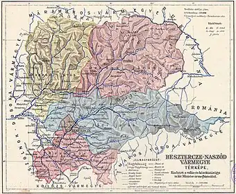
In the early 20th century, the subdivisions of the county Beszterce-Naszód were:
| Districts (járás) | |
|---|---|
| District | Capital |
| Besenyő | Beszterce (now Bistrița) |
| Jád | Jád (now Livezile) |
| Naszód | Naszód (now Năsăud) |
| Óradna | Óradna (now Rodna) |
| Urban districts (rendezett tanácsú város) | |
| Beszterce (now Bistrița) | |
Notes
- Only linguistic communities > 1% are displayed.
- Only religious communities > 1% are displayed.
See also
References
- "Az 1881. év elején végrehajtott népszámlálás főbb eredményei megyék és községek szerint rendezve, II. kötet (1882)". library.hungaricana.hu. Retrieved 2021-09-28.
- "A Magyar Korona országainak helységnévtára (1892)". library.hungaricana.hu. Retrieved 2021-09-29.
- "A MAGYAR KORONA ORSZÁGAINAK 1900". library.hungaricana.hu. Retrieved 2021-09-29.
- "KlimoTheca :: Könyvtár". Kt.lib.pte.hu. Retrieved 2021-09-29.
