Csík County
Csík (Hungarian, in Romanian: Ciuc) was an administrative county (comitatus) of the Kingdom of Hungary. Its territory is now in central Romania (eastern Transylvania). The capital of the county was Csíkszereda (now Miercurea Ciuc).
| Csík County | |
|---|---|
| County of the Kingdom of Hungary (1876-1920, 1940-1945) | |
 Coat of arms
| |
 | |
| Capital | Csíkszereda |
| Area | |
| • Coordinates | 46°22′N 25°48′E |
• 1910 | 4,859 km2 (1,876 sq mi) |
| Population | |
• 1910 | 145720 |
| History | |
| History | |
• Established | 1876 |
| 4 June 1920 | |
• County recreated (Second Vienna Award) | 30 August 1940 |
• Disestablished | 1945 |
| Today part of | Romania |
| Miercurea Ciuc is the current name of the capital. | |
Geography
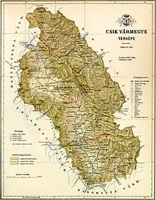
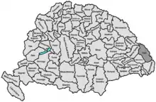
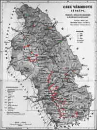
Csík county shared borders with Kingdom of Romania and the Hungarian counties of Beszterce-Naszód, Maros-Torda, Udvarhely and Háromszék. The county was situated in the Carpathian Mountains, around the sources and upper courses of the rivers Olt and Mureș. Its area was 4,859 km2 around 1910.
History
Csík county consisted of three former seats of the Székelys: Csíkszék, Gyergyószék and Kászonszék (the latter two as filial seats of the former). It was formed in 1876, when the administrative structure of Transylvania was changed. In 1920, by the Treaty of Trianon, the county became part of Romania. It was returned to Hungary by the Second Vienna Award of 1940. After World War II, it became again part of Romania. Most of its territory lies in the present-day Romanian county of Harghita, with small parts in Suceava, Neamț and Bacău.
Demographics
| Census | Total | Hungarian | Romanian | Other or unknown |
|---|---|---|---|---|
| 1880[1] | 110,940 | 92,802 (86.92%) | 12,836 (12,02%) | 1,135 (1.06%) |
| 1890[2] | 114,110 | 98,861 (86.64%) | 14,470 (12.68%) | 779 (0.68%) |
| 1900[3] | 128,382 | 110,963 (86.43%) | 15,936 (12.41%) | 1,483 (1.16%) |
| 1910[4] | 145,720 | 125,888 (86.39%) | 18,032 (12.37%) | 1,800 (1.24%) |
| Census | Total | Roman Catholic | Greek Catholic | Jewish | Calvinist | Other or unknown |
|---|---|---|---|---|---|---|
| 1880 | 110,940 | 91,627 (82.59%) | 17,485 (15.76%) | 528 (0.48%) | 321 (0.29%) | 979 (0.88%) |
| 1890 | 114,110 | 93,415 (81.86%) | 18,532 (16.24%) | 706 (0.62%) | 465 (0.41%) | 992 (0.87%) |
| 1900 | 128,382 | 104,287 (81.23%) | 21,100 (16.44%) | 1,518 (1.18%) | 956 (0.74%) | 521 (0.41%) |
| 1910 | 145,720 | 117,351 (80.53%) | 23,724 (16.28%) | 2,357 (1.62%) | 1,689 (1.16%) | 599 (0.41%) |
Subdivisions
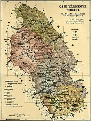
In the early 20th century, the subdivisions of Csík county were:
| Districts (járás) | |
|---|---|
| District | Capital |
| Felcsík | Csíkszereda (now Miercurea Ciuc) |
| Gyergyószentmiklós | Gyergyószentmiklós (now Gheorgheni) |
| Gyergyótölgyes | Gyergyótölgyes (now Tulgheș) |
| Kászonalcsík | Csíkszentmárton (now Sânmartin) |
| Szépvíz (from 1913) | Szépvíz (now Frumoasa) |
| Urban districts (rendezett tanácsú város) | |
| Csíkszereda (now Miercurea Ciuc) | |
| Gyergyószentmiklós (now Gheorgheni) | |
See also
Notes
- Only linguistic communities > 1% are displayed.
- Only religious communities > 1% are displayed.
References
- "Az 1881. év elején végrehajtott népszámlálás főbb eredményei megyék és községek szerint rendezve, II. kötet (1882)". library.hungaricana.hu. Retrieved 2021-09-28.
- "A Magyar Korona országainak helységnévtára (1892)". library.hungaricana.hu. Retrieved 2021-09-29.
- "A MAGYAR KORONA ORSZÁGAINAK 1900". library.hungaricana.hu. Retrieved 2021-09-29.
- "KlimoTheca :: Könyvtár". Kt.lib.pte.hu. Retrieved 2021-09-29.
