Behbahan
Behbahan (Persian: بهبهان, also romanized as Behbahān and Behbehān)[3] is a city in the Central District of Behbahan County, Khuzestan province, Iran, and serves as both capital of the county and of the district.
Behbahan
Persian: بهبهان | |
|---|---|
City | |
 | |
 Behbahan | |
| Coordinates: 30°35′39″N 50°14′36″E[1] | |
| Country | Iran |
| Province | Khuzestan |
| County | Behbahan |
| District | Central |
| Population (2016)[2] | |
| • Total | 122,604 |
| Time zone | UTC+3:30 (IRST) |
At the 2006 National Census, its population was 99,204 in 24,204 households.[4] The following census in 2011 counted 107,412 people in 29,280 households.[5] The latest census in 2016 showed a population of 122,604 people in 35,826 households.[2]
Etymology
The origin of the name "Behbahan" may be from two words: "Beh" meaning 'good, better', and "Bahan" meaning "tent." Settlers in the land may had priorly been tent dwellers, and upon building homes in the area referred to them as 'better than tents'.[6]
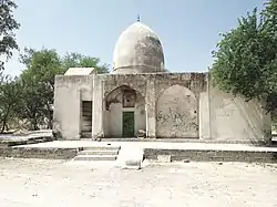
Historical monuments
The historical tomb of the Jew Bashir and Nazir in the city of Behbahan is a symbol of this city and is considered one of the oldest historical monuments in the province of Khuzestan.[7][8]
Climate
Behbahan has a hot semi-arid climate (Köppen: BSh), characterised by sweltering and rainless summers and pleasant winters with occasional heavy rainfall.
| Climate data for Behbahan (1991-2021) | |||||||||||||
|---|---|---|---|---|---|---|---|---|---|---|---|---|---|
| Month | Jan | Feb | Mar | Apr | May | Jun | Jul | Aug | Sep | Oct | Nov | Dec | Year |
| Average high °C (°F) | 16.7 (62.1) |
18.9 (66.0) |
24.4 (75.9) |
30.5 (86.9) |
38.2 (100.8) |
42.9 (109.2) |
44.3 (111.7) |
44.1 (111.4) |
40.3 (104.5) |
34.6 (94.3) |
24.2 (75.6) |
18.5 (65.3) |
31.5 (88.6) |
| Average low °C (°F) | 6.0 (42.8) |
7.2 (45.0) |
10.5 (50.9) |
15.5 (59.9) |
21.1 (70.0) |
25.4 (77.7) |
28.2 (82.8) |
27.9 (82.2) |
23.9 (75.0) |
19.2 (66.6) |
12.6 (54.7) |
7.9 (46.2) |
17.1 (62.8) |
| Average rainfall mm (inches) | 117 (4.6) |
75 (3.0) |
69 (2.7) |
28 (1.1) |
6 (0.2) |
0 (0) |
0 (0) |
1 (0.0) |
1 (0.0) |
5 (0.2) |
74 (2.9) |
116 (4.6) |
492 (19.3) |
| Source: Climate-data.org | |||||||||||||
See also
References
- OpenStreetMap contributors (27 July 2023). "Behbahan, Behbahan County" (Map). OpenStreetMap. Retrieved 27 July 2023.
- "Census of the Islamic Republic of Iran, 1395 (2016)". AMAR (in Persian). The Statistical Center of Iran. p. 06. Archived from the original (Excel) on 21 October 2020. Retrieved 19 December 2022.
- Behbahan can be found at GEOnet Names Server, at this link, by opening the Advanced Search box, entering "-3055917" in the "Unique Feature Id" form, and clicking on "Search Database".
- "Census of the Islamic Republic of Iran, 1385 (2006)". AMAR (in Persian). The Statistical Center of Iran. p. 06. Archived from the original (Excel) on 20 September 2011. Retrieved 25 September 2022.
- "Census of the Islamic Republic of Iran, 1390 (2011)" (Excel). Iran Data Portal (in Persian). The Statistical Center of Iran. p. 06. Retrieved 19 December 2022.
- "Meaning of Behbahan - معنى بهبهان". 14 July 2011. Archived from the original on 14 July 2011. Retrieved 6 February 2021.
- The Behbahanis were mostly Jews before the Arab invasion, and the proof of this claim is the tomb of Bashir and Nazir, two Jewish prophets, which the Behbahani still visit on Saturdays. "Ahvaz Chamber of Commerce". www.ahvazccim.com. Retrieved 10 October 2022.
{{cite web}}: CS1 maint: multiple names: authors list (link) - The history of the Jewish people in the land of Khuzestan. (21 April 2014). ""عید پاک" و گذری بر قوم یهود در اقلیم احواز". جنبش ملی الاحواز (in Arabic). Retrieved 10 October 2022.
External links

| Capital | |||||||||||||||||||||||||||||||
|---|---|---|---|---|---|---|---|---|---|---|---|---|---|---|---|---|---|---|---|---|---|---|---|---|---|---|---|---|---|---|---|
| Districts |
| ||||||||||||||||||||||||||||||