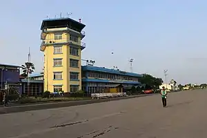
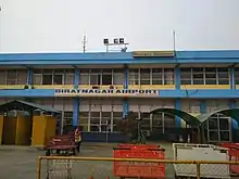
Biratnagar Airport
Biratnagar Airport (IATA: BIR, ICAO: VNVT) is a domestic airport located in Biratnagar serving Morang District, Koshi Province, Nepal.[1] Biratnagar Airport is the third busiest airport in Nepal after Kathmandu and Pokhara.[3] There are plans to upgrade the airport to serve international flights very soon.[4]
Biratnagar Airport विराटनगर विमानस्थल | |||||||||||
|---|---|---|---|---|---|---|---|---|---|---|---|
 | |||||||||||
| Summary | |||||||||||
| Airport type | Public | ||||||||||
| Owner | Government of Nepal | ||||||||||
| Operator | Civil Aviation Authority of Nepal | ||||||||||
| Serves | Biratnagar, Nepal | ||||||||||
| Focus city for | |||||||||||
| Elevation AMSL | 236 ft / 72 m | ||||||||||
| Coordinates | 26°28′53″N 87°15′50″E | ||||||||||
| Map | |||||||||||
 Biratnagar Airport Location of airport in Nepal | |||||||||||
| Runways | |||||||||||
| |||||||||||
History


Biratnagar Airport commenced operations on 6 July 1958.[5]
On 15 August 2017, during the August 2017 Nepal and India floods the runway of Biratnagar Airport was flooded, along with other parts of India and Nepal, and the airport was forced to suspend its operations.[6]
In 2019, the Civil Aviation Authority of Nepal decided to upgrade the Biratnagar Airport to an international level, which includes lengthening the runway.[7] In 2022, locals demonstrated, as they still were not compensated for the land that the Government was purchasing to expand the airport area.[8]
Facilities
The airport is located at an elevation of 236 feet (72 m) above mean sea level. It has one runway designated 09/27 with an asphalt surface measuring 1,505 by 30 metres (4,938 ft × 98 ft).[1] The airport is one of the few airports in Nepal that has its own aviation fuel depot on site, enabling aircraft to refuel here during turnover periods.[9]
Airlines and destinations
| Airlines | Destinations |
|---|---|
| Buddha Air | Kathmandu, Pokhara–International,[10] Tumlingtar |
| Saurya Airlines | Kathmandu, Siddharthanagar[11] |
| Shree Airlines | Kathmandu |
| Yeti Airlines | Kathmandu[12] |
Accidents and incidents
- 10 June 1973(2030 jestha 28) – 1973 Nepal plane hijack: A Royal Nepal Airlines flight from Biratnagar to Kathmandu, operated by a de Havilland Canada DHC-6 Twin Otter (9N-ABB), was taken over by three hijackers of the Nepali Congress party who demanded money and escaped after landing in Bihar, India. None of the three crew and 18 passengers were injured.[13]
- 18 November 1981, a Pilatus PC-6 (Porter & Turbo Porter) of Royal Nepal Airlines cashed after initial climb after it lost height. The fatalities included 1 crew and 9 passengers.[14]
- In October 2021, the airport closed for four days due to flooding of runway by torrential rainfall.[15][16]
See also
References
- Airport information for VNVT Archived 6 August 2011 at the Wayback Machine from DAFIF (effective October 2006)
- Airport information for Biratnagar, Nepal (VNVT / BIR) at Great Circle Mapper. Source: DAFIF (effective October 2006).
- "Biratnagar Airport" (PDF). Civil Aviation Authority of Nepal. Retrieved 1 May 2019.
- "Biratnagar airport to be upgraded to international standard". The Himalayan Times. 6 October 2020. Retrieved 3 November 2020.
- "Biratnagar Airport". Civil Aviation Authority of Nepal. Archived from the original on 24 July 2011. Retrieved 2 November 2010.
- "Biratnagar Airport shut down". The Himalayan Times. 15 August 2017. Retrieved 17 August 2017.
- "विराटनगर विमानस्थललाई 'अन्तर्राष्ट्रिय स्तर' को बनाइने" [The Biratnagar Airport will be upgraded to at "International level".] (in Nepali). Kantipur Media Group. 24 November 2020. Retrieved 24 November 2020.
- Bhandari, Binod (14 June 2022). "Locals affected by Biratnagar Airport expansion project protest". The Kathmandu Post. Retrieved 19 June 2022.
- "Majority of airports in Nepal lack fuel depot facility". Aviation Nepal. 5 March 2018. Retrieved 13 March 2018.
- Pokharel, Santosh. "Flights to and from Pokhara Airport affected as fuel tanker overturns near runway". My Republica. Retrieved 7 July 2022.
- Republica. "Saurya Airlines to start Biratnagar-Bhairahawa direct flight service". My Republica. Retrieved 12 July 2022.
- Domestic Flights in Nepal, Kathmandu to Biratanagar (Yeti Airlines), retrieved 8 July 2022
- "Nepal Magazine Archived 2 March 2014 at the Wayback Machine". Retrieved 18 November 2006.
- "Crash of a Pilatus PC-6 Turbo Porter in Biratnagar: 10 killed | Bureau of Aircraft Accidents Archives". www.baaa-acro.com. Retrieved 14 October 2022.
- "विराटनगर विमानस्थल आजदेखि खुल्ने, बेलुका ५ बजेपछि उडान नहुने". Setopati. Retrieved 23 October 2021.
- "Torrential rainfall inundates Biratnagar Airport". Nepal Press. Retrieved 23 October 2021.