Boerdonk
Boerdonk is a village in the south of the Netherlands. It is situated in the municipality of Meierijstad, North Brabant.
Boerdonk | |
|---|---|
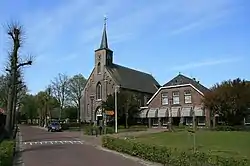 Sint Servatiuskerk | |
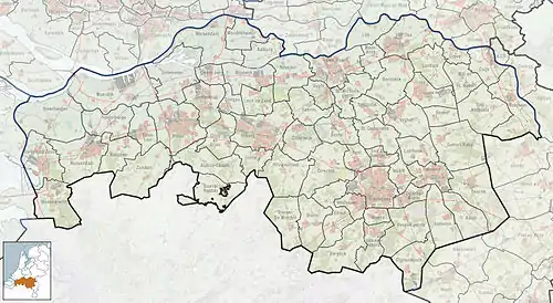 Boerdonk Location in the province of North Brabant in the Netherlands  Boerdonk Boerdonk (Netherlands) | |
| Coordinates: 51°33′35″N 5°37′37″E | |
| Country | Netherlands |
| Province | North Brabant |
| Municipality | Meierijstad |
| Area | |
| • Total | 0.71 km2 (0.27 sq mi) |
| Elevation | 11 m (36 ft) |
| Population (2021)[1] | |
| • Total | 1,435 |
| • Density | 2,000/km2 (5,200/sq mi) |
| Time zone | UTC+1 (CET) |
| • Summer (DST) | UTC+2 (CEST) |
| Postal code | 5469[1] |
| Dialing code | 0413 |
| Major roads | N279 |
The village was first mentioned in 1311 as Boerdonc.[3] It developed along the Boerdonkse Aa. Boerdonk was home to 177 people in 1840. Until the municipal reorganization of 1994, Boerdonk was located in the municipality of Erp. Since 2017, it is part of the municipality of Meierijstad.[4]
References
- "Kerncijfers wijken en buurten 2021". Central Bureau of Statistics. Retrieved 17 April 2022.
two entries
- "Postcodetool for 5469AA". Actueel Hoogtebestand Nederland (in Dutch). Het Waterschapshuis. Retrieved 17 April 2022.
- "Boerdonk - (geografische naam)". Etymologiebank (in Dutch). Retrieved 16 April 2022.
- "Boerdonk". Plaatsengids (in Dutch). Retrieved 17 April 2022.
Wikimedia Commons has media related to Boerdonk.
This article is issued from Wikipedia. The text is licensed under Creative Commons - Attribution - Sharealike. Additional terms may apply for the media files.