Bolívar Province (Ecuador)
Bolívar (Spanish pronunciation: [boˈliβaɾ]) is a province in Ecuador. The capital is Guaranda. Much of the province has a cool, 'sierra' climate, as it is located in the Andes Mountains. The area in the lower foothills has a cold, tundra-like climate.
Bolivar | |
|---|---|
Province | |
| Province of Bolivar | |
 Flag  Seal | |
.svg.png.webp) Location of the Bolívar Province in Ecuador. | |
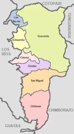
 Cantons of Bolívar Province | |
| Coordinates: 1°36′S 79°0′W | |
| Country | Ecuador |
| Established | 1827 |
| Capital | Guaranda |
| Cantons | List of Cantons |
| Area | |
| • Total | 3,945.38 km2 (1,523.32 sq mi) |
| Population (2010 census) | |
| • Total | 183,641 |
| • Density | 47/km2 (120/sq mi) |
| • Population 2001 | 173,840 |
| Time zone | UTC-5 (ECT) |
| Vehicle registration | B |
| HDI (2017) | 0.714[1] high · 19th |
| Website | www |
Cantons
The province is divided into seven cantons. The following table lists each with its population as of the 2010 census, its area in square kilometres (km2), and the name of the canton seat or capital.[2]
| Canton | Pop. (2019) | Area (km2) | Seat/Capital |
|---|---|---|---|
| Caluma | 16,160 | 176.54 | Caluma |
| Chillanes | 17,020 | 662.67 | Chillanes |
| Chimbo | 17,320 | 261.42 | Chimbo |
| Echeandía | 13,960 | 230.33 | Echeandía |
| Guaranda | 107,590 | 1,892.08 | Guaranda |
| Las Naves | 7,330 | 148.82 | Las Naves |
| San Miguel | 29,010 | 573.52 | San Miguel |
Demographics
Ethnic groups as of the Ecuadorian census of 2010:[3]
- Mestizo 69.6%
- Indigenous 25.4%
- White 2.7%
- Montubio 1.1%
- Afro-Ecuadorian 1.1%
- Other 0.1%
Politics
Results of the Ecuadorian presidential elections of 2013 in Bolívar Province:[4]
- Rafael Correa (PAIS) 33.7%
- Guillermo Lasso (CREO) 27.7%
- Lucio Gutiérrez (PSP) 25.4%
- Mauricio Rodas (SUMA) 4.9%
- Alberto Acosta (UPI) 4.2%
- Álvaro Noboa (PRIAN) 2.4%
- Norman Wray (Ruptura 25) 1.0%
- Nelson Zavala (PRE) 0.8%
See also
References
- Villalba, Juan. "Human Development Index in Ecuador". Scribd (in Spanish). Retrieved 2019-02-05.
- "Cantons of Ecuador". Archived from the original on 2017-01-31. Retrieved 2014-06-01.
- "Resultados".
- http://www.cne.gob.ec/
This article is issued from Wikipedia. The text is licensed under Creative Commons - Attribution - Sharealike. Additional terms may apply for the media files.