Bolton, Ontario
Bolton (2021 population 26,795)[1] is an unincorporated town that is the most populous community in the town of Caledon, Ontario. It is located beside the Humber River in the Region of Peel, approximately 50 kilometres northwest of Toronto. In regional documents, it is referred to as a 'Rural Service Centre'.[2] It has 26,795 residents in 9,158 total dwellings.[3] The downtown area that historically defined the village is in a valley, through which flows the Humber River. The village extends on either side of the valley to the north and south.
Bolton | |
|---|---|
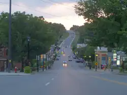 Queen Street (Highway 50) in Bolton | |
 Bolton  Bolton | |
| Coordinates: 43°52′50″N 79°44′17″W | |
| Country | Canada |
| Province | Ontario |
| Regional municipality | Peel |
| Town | Caledon |
| Ward | 5 |
| Area | |
| • Land | 20.71 km2 (8.00 sq mi) |
| Population | |
| • Total | 26,795 |
| • Density | 1,294.0/km2 (3,351/sq mi) |
| Time zone | UTC-5 (EST) |
| • Summer (DST) | UTC-4 (EDT) |
| Forward Sortation Area | |
| Area codes | 905, 289, 365, and 742 |
| NTS Map | 30M13 Bolton |
| GNBC Code | FDJLH |
Geography
The conservation lands' forests dominate a large part of the north and the east, including along the Humber valley. These conservation lands have created several recreational areas, including parts of the Humber Valley Heritage Trail. Farmland and the protected Oak Ridges Moraine dominate the landscape surrounding the village.
There are two 400-series highways nearby, including Highway 427, about 9 km southeast (the highway's northern terminus being at Major Mackenzie Drive), and Highway 400, about 14 km east (exit at King Road).
History
The community, formerly known as Bolton Mills, was founded around 1822 when James Bolton helped build a flour mill for his relative George Bolton. By 1857, Bolton was a village with a population of 700 in the Township of Albion in Peel County.
It was established on the Humber River, on the line of the proposed Toronto, Grey and Bruce Railway. There were stages to and from Weston. The average price of land was $40 to $50 per acre.[4]
Demographics
As of the 2021 census, the top three ethnic groups in Bolton are Italian (11,480; 43.4%), English (3,540; 13.4%) and Canadian (3,120; 11.8%).[5]
Organizations
- Freemasonry
- Kinsmen Club of Bolton, chartered in 1964
Media
The 1996 Warner Bros. film Twister and the 2005 film Four Brothers were partially shot here.
Education
Bolton is home to several public and Catholic schools:
Public Elementary Institutions:
- Allan Drive Middle School
- Ellwood Memorial Public School
- James Bolton Public School
- Macville Public School (just outside Bolton located in Caledon)
Public Secondary Institutions:
Catholic Elementary Institutions:
- Holy Family Elementary School
- St. John Paul II Elementary School
- St. John the Baptist Elementary School
- St. Nicholas Elementary School
Catholic Secondary Institutions:
- St. Michael Catholic Secondary School
Private Institutions:
- King's College School (Just outside Bolton located in Caledon)
- Creative Children's Montessori School
Notable residents
- Lorne Duguid – hockey player
- Keith McCreary – hockey player, former Chairman of the NHL Alumni, politician
- James East – politician
- Todd Elik – hockey player
- Organik – musician and founder of King of the Dot
- Steven Halko – hockey player
- Peter Holland – hockey player
- Andrew Mangiapane – hockey player
- Skye Sweetnam – singer
- Jason Saggo – UFC Fighter
- Joseph Shabason – ambient jazz musician
References
- "Bolton, Ontario (Population Centre)". Census Profile, Canada 2021 Census. Statistics Canada. 9 February 2022. Retrieved 12 February 2022.
- "Bolton Residential Expansion Study". Town of Caledon. Retrieved 4 October 2017.
- (Town of Caledon Population Distribution - June 30, 2006 - http://www.town.caledon.on.ca/contentc/townhall/statistics/Caledon_Population_Distribution_30JUN06.pdf Archived 2011-05-27 at the Wayback Machine)
- The province of Ontario gazetteer and directory. H. McEvoy, Editor and Compiler, Toronto. Robertson & Cook, Publishers, 1869.
- Canada, Government of Canada, Statistics (October 26, 2022). "Census Profile, 2021 Census of Population Profile table". www12.statcan.gc.ca. Retrieved October 26, 2022.
{{cite web}}: CS1 maint: multiple names: authors list (link)
External links
Places adjacent to Bolton, Ontario | |
|---|---|
Largest city: Toronto | ||
| Regions |  | |
| Cities | ||
| Towns | ||
| Townships | ||
| Municipalities | ||