Bosna (river)
The Bosna (Serbian Cyrillic: Босна, pronounced [bɔ̂sna]) is the third longest river in Bosnia and Herzegovina, and is considered one of the country's three major internal rivers, along with the Neretva and the Vrbas. The other three major rivers of Bosnia and Herzegovina are the Una, to the northwest; the Sava, to the north, and the Drina, to the east. This river is the namesake of Bosnia. The river Bosna flows for 282 kilometers (175 mi).[1]
| Bosna | |
|---|---|
.jpg.webp) The Bosna River flowing through Zenica. | |
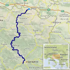 Course of the Bosna (interactive map) | |
| Location | |
| Country | Bosnia and Herzegovina |
| Cities | Visoko, Kakanj, Zenica, Maglaj, Zavidovići, Doboj, Modriča, Bosanski Šamac |
| Physical characteristics | |
| Source | Vrelo Bosne |
| • location | Igman, Ilidža, Bosnia and Herzegovina |
| • coordinates | 43°49′6.6″N 18°16′11.9″E |
| • elevation | 503 m (1,650 ft) |
| Mouth | Sava |
• location | Bosanski Šamac, Bosnia and Herzegovina |
• coordinates | 45°4′0″N 18°28′1″E |
• elevation | 78 m (256 ft) |
| Length | 281.6 km (175.0 mi)[1] |
| Basin size | 10,810 km2 (4,170 sq mi)[1] |
| Discharge | |
| • average | 174 m3/s (6,100 cu ft/s) |
| Basin features | |
| Progression | Sava→ Danube→ Black Sea |
The river is possibly mentioned for the first time during the 1st century AD by Roman historian Marcus Velleius Paterculus under the name Bathinus flumen.[2][3][4] Another basic source that is associated with the hydronym Bathinus is the Salonitan inscription of the governor of Dalmatia, Publius Cornelius Dolabella, where it is said that the Bathinum river divides the Breuci from the Osseriates.[5] Another name could also have been Basante.
According to philologist Anton Mayer, the name Bosna could be derived from Illyrian Bass-an-as(-ā), which would be a diversion of the Proto-Indo-European root bʰegʷ, meaning 'the running water'.[6]
Geography and sectioning
The Bosna River has created the Bosna River Valley. The valley has been developed as the country's industrial hub and is home to nearly a million people, who live primarily in several major cities.
Upper Bosna
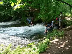
The source of the river is at the spring Vrelo Bosne, at the foothills of Mount Igman, on the outskirts of Sarajevo, capital of Bosnia and Herzegovina. The spring is one of Bosnia and Herzegovina's chief natural landmarks and tourist attractions. Its tributaries in the region are the Dobrinja, Tilava, Večerica, Zujevina, and Željeznica rivers.[7]
The Upper Bosna is a section between its source and the mouth of the Lašva, a left tributary, just upstream from Zenica. The section encompasses the entire region between Ilidža, near Sarajevo, and the Lašva, including the spacious valley between Ilijaš and Kakanj. The Visoko region, with its medieval heritage, is at the center of this area.
Middle Bosna
The Middle Bosna is mostly composed of gorges, with steep slopes and narrow passages, between Zenica and Doboj. In this section, there are several medieval sites, such as Vranduk, Maglaj and Doboj.
Lower Bosna
The Lower Bosna is the last section of the Bosna. From Doboj, the river continues northwards, approaching the Sava through the heart of Bosnia, passing through the lowlands of Posavina, and eventually becomes a right tributary of the Sava in Bosanski Šamac. There, it empties at around 80 metres (260 ft) above the sea level.
Course and tributaries
The Bosna flows through a number of cantons. From its starting point in the Sarajevo Canton, it flows through the Zenica-Doboj Canton, and the Posavina Canton, in that order. On its way north, the Bosna also passes through the cities of Visoko, Zenica, Maglaj, Doboj, Modriča and Bosanski Šamac.
The main right tributaries are: Željeznica, Miljacka, Ljubina, Misoča, Stavnja, Trstionica, Gostović, Krivaja and Spreča. On the left, the main tributaries are: Zujevina, Fojnica, Lašva and Usora.
.JPG.webp) Bosna river flow outside Sarajevo
Bosna river flow outside Sarajevo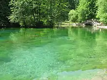 Bosna river pond in Ilidža
.JPG.webp) Bosna river in Ilidža
Bosna river in Ilidža Roman bridge over Bosna river in Ilidža
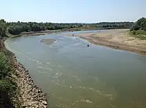 The Lower Bosna near Bosanski Šamac
References
- "Sava River Basin Analysis Report" (PDF). International Sava River Basin Commission. September 2009. p. 13. Archived from the original (PDF, 9.98 MB) on 2010-07-17.
- Šašel Kos, M.; P. Kos. "Places: 197162 (Bathinus (river))". Pleiades. Retrieved January 22, 2017.
- Salmedin Mesihović (2014). Ilirike. Sarajevo: Filozofski fakultet u Sarajevu. p. 80. ISBN 9789958031106.
- Velleius Paterculus, Historia Romana 2.114.4.6 http://latin.packhum.org/loc/1044/1/131/1509-1516
- Salmedin Mesihović (2010). Aevvm Dolabellae – Dolabelino Doba. Vol. XXXIX. Sarajevo: Centar za balkanološka ispitivanja, Akademija nauka i umjetnosti. p. 10.
- Indira Šabić (2014). Onomastička analiza bosanskohercegovačkih srednjovjekovnih administrativnih tekstova i stećaka (PDF). Osijek: Sveučilište Josipa Jurja Strossmayera. p. 165. Archived from the original (PDF) on 2017-01-14. Retrieved 2015-03-30.
- The Geography of Bosnia and Herzegovina Between East and West. Springer. 2022. p. 373. ISBN 978-3-030-98522-6.
