Le Bourg-d'Oisans
Le Bourg-d'Oisans (French pronunciation: [lə buʁ dwazɑ̃]) is a commune in the Isère department in southeastern France.[3]
Le Bourg-d'Oisans | |
|---|---|
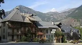 Le Bourg-d'Oisans. In the background the Grandes Rousses massif and the Alpe d'Huez | |
 Coat of arms | |
Location of Le Bourg-d'Oisans | |
 Le Bourg-d'Oisans  Le Bourg-d'Oisans | |
| Coordinates: 45°03′21″N 6°01′49″E | |
| Country | France |
| Region | Auvergne-Rhône-Alpes |
| Department | Isère |
| Arrondissement | Grenoble |
| Canton | Oisans-Romanche |
| Government | |
| • Mayor (2020–2026) | Guy Verney[1] |
| Area 1 | 36 km2 (14 sq mi) |
| Population | 3,285 |
| • Density | 91/km2 (240/sq mi) |
| Time zone | UTC+01:00 (CET) |
| • Summer (DST) | UTC+02:00 (CEST) |
| INSEE/Postal code | 38052 /38520 |
| Elevation | 701–3,121 m (2,300–10,240 ft) (avg. 720 m or 2,360 ft) |
| 1 French Land Register data, which excludes lakes, ponds, glaciers > 1 km2 (0.386 sq mi or 247 acres) and river estuaries. | |
It is located in the Oisans region of the French Alps. Le Bourg-d'Oisans is located in the valley of the Romanche river, on the road from Grenoble to Briançon, and on the south side of the Col de la Croix de Fer. It is often on the route of the Tour de France, as the town sits at the base of the road climbing to Alpe d'Huez with 21 hairpin bends.
It is surrounded by several well-known mountain resorts, including the Alpe d'Huez and Les Deux Alpes. The Écrins National Park lies to the southeast of Le Bourg-d'Oisans.
Population
|
|
References
- "Répertoire national des élus: les maires". data.gouv.fr, Plateforme ouverte des données publiques françaises (in French). 2 December 2020.
- "Populations légales 2020". The National Institute of Statistics and Economic Studies. 29 December 2022.
- INSEE commune file
Wikimedia Commons has media related to Le Bourg-d'Oisans.
This article is issued from Wikipedia. The text is licensed under Creative Commons - Attribution - Sharealike. Additional terms may apply for the media files.