Chirens
Chirens (French pronunciation: [ʃiʁɛ̃s]) is a commune in the Isère département in southeastern France.
Chirens | |
|---|---|
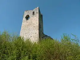 The tower of Clermont | |
Location of Chirens | |
 Chirens  Chirens | |
| Coordinates: 45°24′50″N 5°33′21″E | |
| Country | France |
| Region | Auvergne-Rhône-Alpes |
| Department | Isère |
| Arrondissement | Grenoble |
| Canton | Le Grand-Lemps |
| Intercommunality | CA Pays Voironnais |
| Government | |
| • Mayor (2020–2026) | Christine Guttin[1] |
| Area 1 | 17.53 km2 (6.77 sq mi) |
| Population (2019)[2] | 2,370 |
| • Density | 140/km2 (350/sq mi) |
| Time zone | UTC+01:00 (CET) |
| • Summer (DST) | UTC+02:00 (CEST) |
| INSEE/Postal code | 38105 /38850 |
| Elevation | 441–876 m (1,447–2,874 ft) |
| 1 French Land Register data, which excludes lakes, ponds, glaciers > 1 km2 (0.386 sq mi or 247 acres) and river estuaries. | |
Above the hamlet of Clermont stands the Tour de Clermont, the only remains of the former castle of the Counts of Clermont-Tonnerre.
Population
|
|
See also
References
- "Répertoire national des élus: les maires". data.gouv.fr, Plateforme ouverte des données publiques françaises (in French). 2 December 2020.
- "Populations légales 2020". The National Institute of Statistics and Economic Studies. 29 December 2022.
External links
Wikimedia Commons has media related to Chirens.
This article is issued from Wikipedia. The text is licensed under Creative Commons - Attribution - Sharealike. Additional terms may apply for the media files.