Brassó County
Brassó was an administrative county (comitatus) of the Kingdom of Hungary. Its territory is now in central Romania (south-eastern Transylvania). The capital of the county was Brassó (Brașov in Romanian, Kronstadt in German).
| Brassó County | |
|---|---|
| County of the Kingdom of Hungary | |
| 1876–1920 | |
.svg.png.webp) Coat of arms
| |
 | |
| Capital | Brassó |
| Area | |
| • Coordinates | 45°39′N 25°35′E |
• 1910 | 1,492 km2 (576 sq mi) |
| Population | |
• 1910 | 101109 |
| History | |
| History | |
• Established | 1876 |
| June 4 1920 | |
| Today part of | Romania |
| Brașov is the current name of the capital. | |
Geography
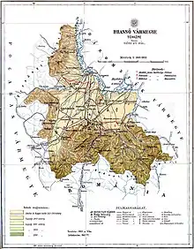
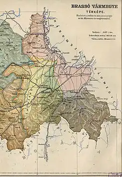
Brassó County shared borders with Romania and the Hungarian counties of Fogaras, Nagy-Küküllő, and Háromszék. The river Olt formed part of its northern border. The ridge of the Southern Carpathian Mountains forms its southern border. Its area was 1,492 km2 (576 sq mi) around 1910.
History
The Brassó/Kronstadt region was settled by German colonists since the 12th century. Brassó County was formed in 1876, when the administrative structure of Transylvania was changed, and was centered on the former Saxon seat of Kronstadt/Brașov. In 1920, by the Treaty of Trianon, the county became part of Romania. Its territory lies in the present Romanian county of Brașov.
Demographics

| Census | Total | Hungarian | Romanian | German | Other or unknown |
|---|---|---|---|---|---|
| 1880[1] | 83,929 | 23,948 (29.62%) | 29,250 (36.18%) | 26,579 (32.87%) | 1,074 (1.33%) |
| 1890[2] | 86,777 | 26,116 (30.10%) | 31,106 (35.85%) | 27,802 (32.04%) | 1,753 (2.02%) |
| 1900[3] | 95,565 | 31,191 (32.64%) | 33,886 (35.46%) | 29,415 (30.78%) | 1,073 (1.12%) |
| 1910[4] | 101,199 | 35,372 (34.95%) | 35,091 (34.68%) | 29,542 (29.19%) | 1,194 (1.18%) |
| Census | Total | Lutheran | Eastern Orthodox | Roman Catholic | Calvinist | Jewish | Unitarian | Greek Catholic | Other or unknown |
|---|---|---|---|---|---|---|---|---|---|
| 1880 | 83,929 | 39,407 (46.95%) | 31,206 (37.18%) | 8,541 (10.18%) | 3,228 (3.85%) | 679 (0.81%) | 466 (0.56%) | 356 (0.42%) | 46 (0.05%) |
| 1890 | 86,777 | 39,905 (45.99%) | 31,579 (36.39%) | 9,837 (11.34%) | 3,489 (4.02%) | 868 (1.00%) | 521 (0.60%) | 561 (0.65%) | 17 (0.02%) |
| 1900 | 95,565 | 42,082 (44.03%) | 33,901 (35.47%) | 10,675 (11.17%) | 5,484 (5.74%) | 1,291 (1.35%) | 1,030 (1.08%) | 1,075 (1.12%) | 27 (0.03%) |
| 1910 | 101,199 | 42,901 (42.39%) | 35,585 (35.16%) | 11,886 (11.75%) | 6,854 (6.77%) | 1,503 (1.49%) | 1,441 (1.42%) | 979 (0.97%) | 50 (0.05%) |
Subdivisions
In the early 20th century, the subdivisions of Brassó County were:
| Districts (járás) | |
|---|---|
| District | Capital |
| Alvidék | Földvár (now Feldioara) |
| Felvidék | Feketehalom (now Codlea) until 1894, then Brassó (now Brașov) |
| Hétfalu | Hosszúfalu (now Săcele) |
| Urban districts (rendezett tanácsú város) | |
| Brassó (now Brașov) | |
Notes
- Only linguistic communities > 1% are displayed.
- Only religious communities > 1% are displayed.
References
- "Az 1881. év elején végrehajtott népszámlálás főbb eredményei megyék és községek szerint rendezve, II. kötet (1882)". library.hungaricana.hu. Retrieved 2021-09-28.
- "A Magyar Korona országainak helységnévtára (1892)". library.hungaricana.hu. Retrieved 2021-09-29.
- "A MAGYAR KORONA ORSZÁGAINAK 1900". library.hungaricana.hu. Retrieved 2021-09-29.
- "KlimoTheca :: Könyvtár". Kt.lib.pte.hu. Retrieved 2021-09-29.
