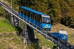
Braunwaldbahn
The Braunwaldbahn, Braunwald-Standseilbahn (BRSB), or Braunwald Funicular, is a funicular railway in the canton of Glarus, Switzerland. The line links Linthal Braunwaldbahn station, on the Swiss Federal Railways' Weesen to Linthal line, with the car-free resort of Braunwald on the mountain 605 m above.[2]
| Braunwaldbahn | |
|---|---|
 | |
| Overview | |
| Other name(s) | Braunwald-Standseilbahn |
| Status | In operation |
| Owner | Braunwald-Standseilbahn AG (since 1994), Braunwaldbahn AG (1905-1994) |
| Locale | Canton of Glarus, Switzerland |
| Termini |
|
| Stations | 2 |
| Service | |
| Type | Funicular |
| Route number | 2840[1] |
| Operator(s) | Braunwald-Standseilbahn AG |
| Rolling stock | 2 for 114 passengers each |
| History | |
| Opened | 6 August 1907 |
| all year service | 1928 |
| Technical | |
| Track length | 1,367 metres (4,485 ft) |
| Number of tracks | 1 with passing loop |
| Track gauge | Metre (3 ft 3+3⁄8 in) |
| Electrification | from opening |
| Highest elevation | 1,254 m (4,114 ft) |
| Maximum incline | 64% |
Operation
The line is operated by the Braunwald-Standseilbahn AG and has the following parameters:[2]
| Feature | Value |
|---|---|
| Number of cars | 2 |
| Number of stops | 2 |
| Configuration | Single track with passing loop |
| Track length | 1,367 metres (4,485 ft) |
| Rise | 605 metres (1,985 ft) |
| Maximum gradient | 64% |
| Track gauge | 1,000 mm (3 ft 3+3⁄8 in) metre gauge |
Further reading
- von Andrian, Walter (1997), "Die neue Standseilbahn Linthal–Braunwald", Schweizer Eisenbahn-Revue (in German) (12): 599–601, ISSN 1022-7113
- Stüssi, Heinrich (1982), "75 Jahre Berg- und Talfahrt", Neujahrsbote für das Glarner Hinterland (in German): 7–40
References
- "2840: Braunwald - Linthal" (PDF), Fahrplanfelder.ch, Tableaux-horaires.ch (in German), 2022, 2840
- Eisenbahnatlas Schweiz. Verlag Schweers+Wall GmbH. 2012. p. 24. ISBN 978-3-89494-130-7.
- "Braunwald". Historical Dictionary of Switzerland (in French). 14 October 2004. Retrieved 28 April 2015.
- "Braunwald - Cable Railway". Braunwald-Klausenpass Tourismus AG. Archived from the original on 10 August 2014. Retrieved 28 April 2015.
External links
 Media related to Braunwaldbahn at Wikimedia Commons
- Braunwaldbahn web page
- Video of ascent of the Braunwaldbahn
This article is issued from Wikipedia. The text is licensed under Creative Commons - Attribution - Sharealike. Additional terms may apply for the media files.