Brazil–Guyana border
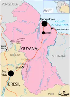
The Brazil–Guyana border is the international border between the territories of Brazil and Guyana. The terrestrial boundary is 1,605 km (997 mi) long.
| Brazil–Guyana border | |
|---|---|
 The border between Brazil and Guyana | |
| Characteristics | |
| Entities | |
| Length | 1605 km (997 mi) |
| History | |
| Established | 1904 |
| Current shape | 1926 |
History
The marshy terrain and lack of easily exploitable natural resources in this region of South America delayed colonization by the Spanish and Portuguese, which allowed the British and Dutch to create colonies along the coasts and rivers. In 1835, just 4 years after the establishment of British Guiana in 1831, increased interest in the region led Prussian explorer Robert Hermann Schomburgk to explore Guiana's interior. After brief land disputes between Britain and Brazil, Schomburgk claimed the entire area between the mouth of the Barima River and the confluence of the Tacutu River and Ireng River, proclaiming the whole area as British domain.[1]
As a resolution to the series of land disputes known as the Pirara question, a treaty was drawn up and signed on November 6, 1901. It was then submitted to the arbitration of King Victor Emmanuel III of Italy who, on June 15, 1904, ruled in favor of Britain and granted them the territory enclosed by the Tacutu and Ireng Rivers.[2][3]
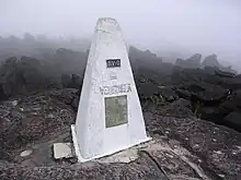
In 1926, a slight modification gave the boundary the present shape, and boundary markers were placed between 1932 and 1939.

References
- Reyner, Anthony S.; Hope, Walter B. (1967). "Guyana's Disputed Borders: A Factual Background". World Affairs. 130 (2): 107–113. ISSN 0043-8200.
- "Boundary between the Colony of British Guiana and the United States of Brazil" (PDF). June 6, 1904.
- Edmundson, G. C. (1923). "The Relations of Great Britain with Guiana". Transactions of the Royal Historical Society. 6: 1–21. doi:10.2307/3678425. ISSN 0080-4401.