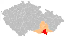
Břeclav District
Břeclav District (Czech: okres Břeclav) is a district in the South Moravian Region of the Czech Republic. Its capital is the town of Břeclav.
Břeclav District
Okres Břeclav | |
|---|---|
 Location in the South Moravian Region within the Czech Republic | |
| Coordinates: 48°51′N 16°49′E | |
| Country | |
| Region | South Moravian |
| Capital | Břeclav |
| Area | |
| • Total | 1,037.97 km2 (400.76 sq mi) |
| Population (2023)[2] | |
| • Total | 117,576 |
| • Density | 110/km2 (290/sq mi) |
| Time zone | UTC+1 (CET) |
| • Summer (DST) | UTC+2 (CEST) |
| Municipalities | 63 |
| * Towns | 9 |
| * Market towns | 4 |
Administrative division
Břeclav District is divided into three administrative districts of municipalities with extended competence: Břeclav, Hustopeče and Mikulov.
List of municipalities
Towns are marked in bold and market towns in italics:
Bavory - Boleradice - Borkovany - Bořetice - Břeclav - Březí - Brod nad Dyjí - Brumovice - Bulhary - Diváky - Dobré Pole - Dolní Dunajovice - Dolní Věstonice - Drnholec - Hlohovec - Horní Bojanovice - Horní Věstonice - Hrušky - Hustopeče - Jevišovka - Kašnice - Klentnice - Klobouky u Brna - Kobylí - Kostice - Křepice - Krumvíř - Kurdějov - Ladná - Lanžhot - Lednice - Mikulov - Milovice - Moravská Nová Ves - Moravský Žižkov - Morkůvky - Němčičky - Nikolčice - Novosedly - Nový Přerov - Pavlov - Perná - Podivín - Popice - Pouzdřany - Přítluky - Rakvice - Šakvice - Sedlec - Šitbořice - Starovice - Starovičky - Strachotín - Tvrdonice - Týnec - Uherčice - Valtice - Velké Bílovice - Velké Hostěrádky - Velké Němčice - Velké Pavlovice - Vrbice - Zaječí
Geography
Břeclav District borders Austria in the south and Slovakia in the southeast. The territory of the district is predominantly lowland and belongs to the warmest areas in the country. The territory extends into five geomorphological mesoregions: Lower Morava Valley (most of the territory), Mikulov Highlands (southwest), Dyje–Svratka Valley (west), Ždánice Forest (north) and Kyjov Hills (small part in the northeast). The highest point of the district is the mountain Děvín in Pavlov with an elevation of 550 m (1,800 ft). The lowest point of the district and entire South Moravian Region is the confluence of the Morava and Thaya rivers in Lanžhot at 150 m (490 ft).
From the total district area of 1,038.0 km2 (400.8 sq mi), agricultural land occupies 682.0 km2 (263.3 sq mi), forests occupy 177.9 km2 (68.7 sq mi), and water area occupies 54.5 km2 (21.0 sq mi). Forests cover 17.1% of the district's area.[1]
The longest river in the area is the Morava, which forms the Czech-Slovak border. However, the most important river for the district is the Thaya, which flows across the territory from northwest to south and briefly forms the Czech-Austrian border before the confluence with the Morava. The Svratka crosses the district in the northwest, otherwise there are no major rivers in the northern part of the district.
Most of the Nové Mlýny reservoirs lie in the district and are the largest body of water of the district. On the Včelínek River is a system of several large ponds, including Nesyt, which belongs to the largest ponds in the country.
Pálava Protected Landscape Area is a protected area that lies entirely in the district.
Demographics
|
|
| ||||||||||||||||||||||||||||||||||||||||||||||||||||||
| Source: Censuses[3][4] | ||||||||||||||||||||||||||||||||||||||||||||||||||||||||
Most populated municipalities
| Name | Population[2] | Area (km2) |
|---|---|---|
| Břeclav | 24,544 | 77 |
| Mikulov | 7,679 | 45 |
| Hustopeče | 6,248 | 25 |
| Velké Bílovice | 3,884 | 26 |
| Lanžhot | 3,632 | 55 |
| Valtice | 3,559 | 48 |
| Velké Pavlovice | 3,132 | 23 |
| Podivín | 2,974 | 18 |
| Moravská Nová Ves | 2,585 | 23 |
| Klobouky u Brna | 2,495 | 31 |
Economy
The largest employers with headquarters in Břeclav District and at least 500 employees are:[5]
| Economic entity | Location | Number of employees | Main activity |
|---|---|---|---|
| Břeclav Hospital | Břeclav | 1,000–1,499 | Health care |
| Gebauer a Griller Kabeltechnik | Mikulov | 1,000–1,499 | Manufacture of electric wires and cables |
| Gumotex Coating | Břeclav | 500–999 | Manufacture of rubber compounds and products |
| Otis | Břeclav | 500–999 | Manufacture of elevators and escalators |
| Norma Czech | Hustopeče | 500–999 | Manufacture of metal products |
| Jednota, spotřební družstvo v Mikulově | Mikulov | 500–999 | Retail sale |
Transport
The D2 motorway from Brno to Czech-Slovak border, which is part of the European route E65, leads across the district.
Sights
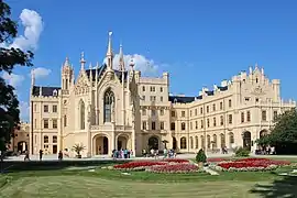
The village of Lednice–Valtice Cultural Landscape was designated a UNESCO World Heritage Site in 1996 because of its unique mix of Baroque, Neolassical, and neo-Gothic architecture, and its history as a cultural landscape designed intentionally by a single family.[6]
The most important monuments in the district, protected as national cultural monuments, are:[7]
- Lednice Castle
- Valtice Castle
- Dolní Věstonice archaeological site
- Pavlov archaeological site
- Vineyard house No. 145 in Pavlov
- Svatý Kopeček Hill in Mikulov with the pilgrimage chapel of St. Sebastian
The best-preserved settlements and landscapes, protected as monument reservations and monument zones, are:[8]
- Břeclav-Pohansko (monument reservation)
- Mikulov (monument reservation)
- Lednice–Valtice Cultural Landscape (monument reservation)
- Pavlov (monument reservation)
- Valtice (monument zone)
The most visited tourist destinations are Svatý Kopeček Hill and Lednice Castle.[9]
Notable people
References
- "Land use (as at 31 December)". Public database. Czech Statistical Office. Retrieved 2023-05-22.
- "Population of Municipalities – 1 January 2023". Czech Statistical Office. 2023-05-23.
- "Historický lexikon obcí České republiky 1869–2011 – Okres Břeclav" (in Czech). Czech Statistical Office. 2015-12-21. pp. 1–2.
- "Population Census 2021: Population by sex". Public Database. Czech Statistical Office. 2021-03-27.
- "Registr ekonomických subjektů". Business Register (in Czech). Czech Statistical Office. Retrieved 2023-02-10.
- "Lednice-Valtice Cultural Landscape". UNESCO. Retrieved 2023-02-10.
- "Výsledky vyhledávání: Národní kulturní památky, okres Břeclav". Ústřední seznam kulturních památek (in Czech). National Heritage Institute. Retrieved 2023-02-10.
- "Výsledky vyhledávání: Památkové rezervace, Památkové zóny, okres Břeclav". Ústřední seznam kulturních památek (in Czech). National Heritage Institute. Retrieved 2023-02-10.
- "Turisté mají v České republice nejraději zoologické zahrady, technické památky, koupání a Pražský hrad" (in Czech). CzechTourism. 2022-06-24. Retrieved 2023-02-10.
External links
- Břeclav District – profile on the Czech Statistical Office website