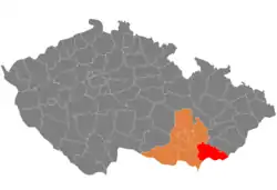
Hodonín District
Hodonín District (Czech: okres Hodonín) is a district in the South Moravian Region of the Czech Republic. Its capital is the town of Hodonín.
Hodonín District
Okres Hodonín | |
|---|---|
 Location in the South Moravian Region within the Czech Republic | |
| Coordinates: 48°57′N 17°11′E | |
| Country | |
| Region | South Moravian |
| Capital | Hodonín |
| Area | |
| • Total | 1,099.00 km2 (424.33 sq mi) |
| Population (2023)[2] | |
| • Total | 152,119 |
| • Density | 140/km2 (360/sq mi) |
| Time zone | UTC+1 (CET) |
| • Summer (DST) | UTC+2 (CEST) |
| Municipalities | 82 |
| * Towns | 8 |
| * Market towns | 0 |
Administrative division
Hodonín District is divided into three administrative districts of municipalities with extended competence: Hodonín, Kyjov and Veselí nad Moravou.
List of municipalities
Towns are marked in bold:
Archlebov - Blatnice pod Svatým Antonínkem - Blatnička - Bukovany - Bzenec - Čejč - Čejkovice - Čeložnice - Dambořice - Dolní Bojanovice - Domanín - Dražůvky - Dubňany - Hodonín - Hovorany - Hroznová Lhota - Hrubá Vrbka - Hýsly - Javorník - Ježov - Josefov - Karlín - Kelčany - Kněždub - Kostelec - Kozojídky - Kuželov - Kyjov - Labuty - Lipov - Louka - Lovčice - Lužice - Malá Vrbka - Mikulčice - Milotice - Mouchnice - Moravany - Moravský Písek - Mutěnice - Násedlovice - Nechvalín - Nenkovice - Nová Lhota - Nový Poddvorov - Ostrovánky - Petrov - Prušánky - Radějov - Ratíškovice - Rohatec - Šardice - Skalka - Skoronice - Sobůlky - Starý Poddvorov - Stavěšice - Strážnice - Strážovice - Sudoměřice - Suchov - Svatobořice-Mistřín - Syrovín - Tasov - Těmice - Terezín - Tvarožná Lhota - Uhřice - Vacenovice - Velká nad Veličkou - Veselí nad Moravou - Věteřov - Vlkoš - Vnorovy - Vracov - Vřesovice - Žádovice - Žarošice - Ždánice - Želetice - Žeravice - Žeraviny
Geography
Hodonín District borders Slovakia in the south. The terrain is very varied. A large part consists of the lowland, which belongs to the warmest and driest areas in the country. The north and southeast of the territory is hilly. The territory extends into seven geomorphological mesoregions: Lower Morava Valley (southwest and centre), Kyjov Hills (a strip from west to east), Ždánice Forest (northwest), Chřiby (small part in the northeast), Vizovice Highlands (east), White Carpathians (southeast), and Chvojnice Hills (a negligible area along the Czech-Slovak border). The highest point of the district is a contour line on the slopes of the mountain Durda in Nová Lhota with an elevation of 838 m (2,749 ft). The lowest point of the district is the river bed of the Morava in Mikulčice at 158 m (518 ft).
From the total district area of 1,099.0 km2 (424.3 sq mi), agricultural land occupies 684.7 km2 (264.4 sq mi), forests occupy 278.7 km2 (107.6 sq mi), and water area occupies 22.2 km2 (8.6 sq mi). Forests cover 25.4% of the district's area.[1]
The main river of the district is the Morava, which flows across the district from east to southwest and partly forms the Czech-Slovak border. Its most important tributaries in the district are Kyjovka and Velička. The Myjava River springs here.
Overall, the territory of the district is poor in bodies of water, but there is a numerous system of ponds on the Kyjovka River. The largest of the ponds is Jarohněvický with an area of almost 100 ha (250 acres).[3]
Bílé Karpaty is a protected landscape area that extends into the district in the southeast.
Demographics
|
|
| ||||||||||||||||||||||||||||||||||||||||||||||||||||||
| Source: Censuses[4][5] | ||||||||||||||||||||||||||||||||||||||||||||||||||||||||
Most populated municipalities
| Name | Population[2] | Area (km2) |
|---|---|---|
| Hodonín | 23,805 | 63 |
| Kyjov | 10,844 | 30 |
| Veselí nad Moravou | 10,642 | 35 |
| Dubňany | 6,266 | 23 |
| Strážnice | 5,401 | 31 |
| Bzenec | 4,565 | 40 |
| Vracov | 4,539 | 44 |
| Ratíškovice | 3,972 | 13 |
| Mutěnice | 3,707 | 32 |
| Svatobořice-Mistřín | 3,527 | 23 |
Economy
The largest employers with headquarters in Hodonín District and at least 500 employees are:[6]
| Economic entity | Location | Number of employees | Main activity |
|---|---|---|---|
| Kyjov Hospital | Kyjov | 1,500–1,999 | Health care |
| Delimax | Hodonín | 500–999 | Food industry |
| TGM Hospital Hodonín | Hodonín | 500–999 | Health care |
| Jednota, spotřební družstvo v Hodoníně | Hodonín | 500–999 | Retail sale |
| Vetropack Moravia Glass | Kyjov | 500–999 | Manufacture of hollow glass |
| The Candy Plus Sweet Factory | Rohatec | 500–999 | Food industry |
| Kordárna Plus | Velká nad Veličkou | 500–999 | Manufacture of technical textiles |
Transport
There are no motorways passing through the district. The most important roads are the I/54 and I/55 roads.
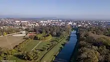
Sights
.jpeg.webp)
The most important monuments in the district, protected as national cultural monuments, are:[7]
- Slavic gord of Mikulčice-Valy
- Milotice Castle
- Windmill in Kuželov
- Belfry in Louka
The best-preserved settlements, protected as monument reservations and monument zones, are:[8]
- Blatnice pod Svatým Antonínkem-Stará Hora (monument reservation)
- Petrov-Plže (monument reservation)
- Kyjov
- Strážnice
- Veselí nad Moravou
- Vápenky
- Javorník-Kopánky
The most visited tourist destination is the Hodonín Zoo.[9]
Notable people
References
- "Land use (as at 31 December)". Public database. Czech Statistical Office. Retrieved 2023-05-22.
- "Population of Municipalities – 1 January 2023". Czech Statistical Office. 2023-05-23.
- "Jaroševický rybník" (in Czech). Jaroševický rybník. Retrieved 2023-02-13.
- "Historický lexikon obcí České republiky 1869–2011 – Okres Hodonín" (in Czech). Czech Statistical Office. 2015-12-21. pp. 1–2.
- "Population Census 2021: Population by sex". Public Database. Czech Statistical Office. 2021-03-27.
- "Registr ekonomických subjektů". Business Register (in Czech). Czech Statistical Office. Retrieved 2023-02-13.
- "Výsledky vyhledávání: Národní kulturní památky, okres Hodonín". Ústřední seznam kulturních památek (in Czech). National Heritage Institute. Retrieved 2023-02-13.
- "Výsledky vyhledávání: Památkové rezervace, Památkové zóny, okres Hodonín". Ústřední seznam kulturních památek (in Czech). National Heritage Institute. Retrieved 2023-02-13.
- "Turisté mají v České republice nejraději zoologické zahrady, technické památky, koupání a Pražský hrad" (in Czech). CzechTourism. 2022-06-24. Retrieved 2023-02-13.
External links
- Hodonín District – profile on the Czech Statistical Office website