Mikulčice
Mikulčice (Czech pronunciation: [ˈmi.kul.tʃi.tsɛ]) is a municipality and village in Hodonín District in the South Moravian Region of the Czech Republic. It has about 2,000 inhabitants.
Mikulčice | |
|---|---|
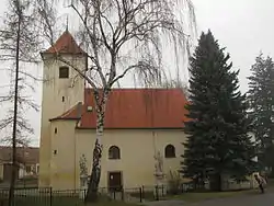 Church of the Assumption of the Virgin Mary | |
 Flag  Coat of arms | |
 Mikulčice Location in the Czech Republic | |
| Coordinates: 48°48′59″N 17°3′4″E | |
| Country | |
| Region | South Moravian |
| District | Hodonín |
| First mentioned | 1141 |
| Area | |
| • Total | 15.30 km2 (5.91 sq mi) |
| Elevation | 165 m (541 ft) |
| Population (2023-01-01)[1] | |
| • Total | 1,966 |
| • Density | 130/km2 (330/sq mi) |
| Time zone | UTC+1 (CET) |
| • Summer (DST) | UTC+2 (CEST) |
| Postal code | 696 19 |
| Website | www |
Administrative parts
.jpg.webp)
The village of Těšice is an administrative part of Mikulčice. Mikulčice and Těšice are urbanistically fused.
Geography
Mikulčice is located about 6 kilometres (4 mi) southeast of Hodonín, on the border with Slovakia. It lies in a flat landscape of the Lower Morava Valley. The municipality is crossed by the Kyjovka river. The Czech-Slovak border is formed here by the Morava River.
History
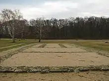
From the 6th until the 10th century, a Slavic fortified settlement existed 3 km southeast from the modern village on the site called Mikulčice-Valy. The settlement was one of the main centres of the Great Moravian Empire, plausibly its capital city. Excavations unearthed the remnants of twelve churches, a palace, and more than 2,500 graves (including a horse burial).[2]
The first written mention of Mikulčice is from 1141. The parish Church of the Assumption of the Virgin Mary was first mentioned in 1353. At the beginning of the 15th century, a fortress stood here. The fortress was probably destroyed during the Hussite Wars.[3]
The village was heavily damaged by the 2021 South Moravia tornado.[4]
Demographics
|
|
| ||||||||||||||||||||||||||||||||||||||||||||||||||||||
| Source: Censuses[5][6] | ||||||||||||||||||||||||||||||||||||||||||||||||||||||||
Economy
The local economy is predominantly based on agriculture and tourism.
Sights
The Mikulčice-Valy site is the main tourist attraction. It is freely accessible. It includes an exhibition with archeological finds from this area, administered by the Masaryk Museum in Hodonín. Since 1962, the site has been protected as a national cultural monument.[7]
Notable people
- Miloslav Balun (1920–1994), pair skater
References
- "Population of Municipalities – 1 January 2023". Czech Statistical Office. 2023-05-23.
- Berend, Nóra (2007). Christianization and the Rise of Christian Monarchy: Scandinavia, Central Europe and Rus' C. 900–1200. Cambridge UP. pp. 216, 321. ISBN 9780521876162. Retrieved 25 June 2012.
- "Historie obce". Obec Mikulčice (in Czech). Retrieved 2021-12-06.
- "Mrtví, zavalení, všude trosky. Sedm obcí na Moravě zpustošilo tornádo". iDnes (in Czech). Retrieved 25 June 2021.
- "Historický lexikon obcí České republiky 1869–2011 – Okres Hodonín" (in Czech). Czech Statistical Office. 2015-12-21. pp. 3–4.
- "Population Census 2021: Population by sex". Public Database. Czech Statistical Office. 2021-03-27.
- "Historie expozice" (in Czech). Masarykovo muzeum v Hodoníně. Retrieved 2023-10-27.