Sudoměřice
Sudoměřice is a municipality and village in Hodonín District in the South Moravian Region of the Czech Republic. It has about 1,300 inhabitants.
Sudoměřice | |
|---|---|
.JPG.webp) Main street | |
 Flag  Coat of arms | |
 Sudoměřice Location in the Czech Republic | |
| Coordinates: 48°52′2″N 17°15′24″E | |
| Country | |
| Region | South Moravian |
| District | Hodonín |
| First mentioned | 1368 |
| Area | |
| • Total | 9.33 km2 (3.60 sq mi) |
| Elevation | 182 m (597 ft) |
| Population (2023-01-01)[1] | |
| • Total | 1,256 |
| • Density | 130/km2 (350/sq mi) |
| Time zone | UTC+1 (CET) |
| • Summer (DST) | UTC+2 (CEST) |
| Postal code | 696 66 |
| Website | www |
Geography
Sudoměřice is located about 9 kilometres (6 mi) east of Hodonín, on the border with Slovakia. It lies in a flat landscape of the Lower Morava Valley. The Baťa Canal flows through the municipality.
Sights
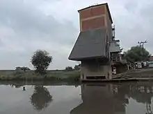
Sudoměřice coal tipper
A technical monument is the Sudoměřice coal tipper. The tipper was used to transfer lignite to ships on the Baťa Canal, which was brought by rail from a nearby mine. It dates from 1939. Today it serves as a lookout tower, and in its interior there is an exhibition about its function.[2]
References
- "Population of Municipalities – 1 January 2023". Czech Statistical Office. 2023-05-23.
- "Technická památka Výklopník na Baťově kanále" (in Czech). CzechTourism. Retrieved 2022-06-29.
Wikimedia Commons has media related to Sudoměřice.
This article is issued from Wikipedia. The text is licensed under Creative Commons - Attribution - Sharealike. Additional terms may apply for the media files.