Ždánice (Hodonín District)
Ždánice (German: Steinitz) is a town in Hodonín District in the South Moravian Region of the Czech Republic. It has about 2,500 inhabitants.
Ždánice | |
|---|---|
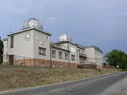 Observatory | |
 Flag  Coat of arms | |
 Ždánice Location in the Czech Republic | |
| Coordinates: 49°4′2″N 17°1′39″E | |
| Country | |
| Region | South Moravian |
| District | Hodonín |
| First mentioned | 1349 |
| Government | |
| • Mayor | Vladimír Okáč |
| Area | |
| • Total | 20.81 km2 (8.03 sq mi) |
| Elevation | 226 m (741 ft) |
| Population (2023-01-01)[1] | |
| • Total | 2,520 |
| • Density | 120/km2 (310/sq mi) |
| Time zone | UTC+1 (CET) |
| • Summer (DST) | UTC+2 (CEST) |
| Postal code | 696 32 |
| Website | www |
Geography
Ždánice is located about 23 kilometres (14 mi) north of Hodonín and 31 km (19 mi) southeast of Brno. It lies in the Ždánice Forest, which is named after the town. A small southern part on the municipal territory lies in the Kyjov Hills. The highest point is the hill U Slepice with an elevation of 439 metres (1,440 ft). A small river called Trkmanka flows through the town.
History
The first written mention of Ždánice is from 1349.[2]
References
- "Population of Municipalities – 1 January 2023". Czech Statistical Office. 2023-05-23.
- "O městě, historie města" (in Czech). Město Ždánice. Retrieved 2021-12-04.
This article is issued from Wikipedia. The text is licensed under Creative Commons - Attribution - Sharealike. Additional terms may apply for the media files.