Brixey, Missouri
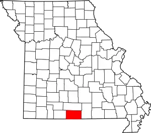
Brixey is a former unincorporated community in northern Ozark County, Missouri, United States.[2] It is located 1.6 miles (2.6 km) south of Route 95 on Route N or approximately 10 miles (16 km) north of Gainesville.[1][3] The store and post office, along with houses along the main road, have been vacant and boarded up for several years as of 2023; there may still be a home or two within the community limits on the back roads, as the Brixeyj name and zip code is still in use for mailings.

Brixey, Missouri | |
|---|---|
Community | |
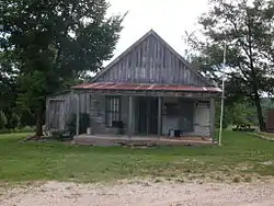
 Old store building at Brixey | |
 Brixey, Missouri Location of Brixey, Missouri | |
| Coordinates: 36°45′3″N 92°24′16″W[1] | |
| Country | U. S. A. |
| State | Missouri |
| County | Ozark County |
| Elevation | 300 m (1,000 ft) |
| Time zone | UTC-6 (CST) |
| • Summer (DST) | UTC-5 (CDT) |
| Zip Code | 65618 |
A post office called Brixey was in operation from 1917 to some time early in the 21st century,[4] although its zip code, 65618, is still in use. The country store, in which it was housed, closed at the same time.[5] A variant spelling was "Brixy".[2] The community takes its name from nearby Brixey Creek[6]
References
- Rockbridge, Missouri, 7.5 Minute Topographic Quadrangle, USGS, 1973
- U.S. Geological Survey Geographic Names Information System: Brixey
- Ava, Missouri, 30x60 Minute Topographic Quadrangle, USGS, 1985
- "Post Offices". Jim Forte Postal History. Retrieved November 27, 2016.
- US Zip Codes
- "Ozark County Place Names, 1928–1945". The State Historical Society of Missouri. Archived from the original on June 24, 2016. Retrieved November 27, 2016.
