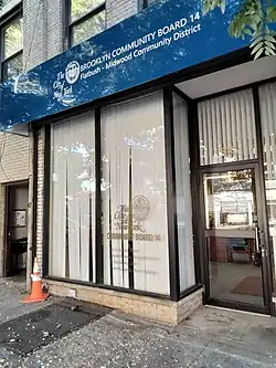
Brooklyn Community Board 14
Brooklyn Community Board 14 is a New York City community board that encompasses the Brooklyn neighborhoods of Flatbush, Midwood, Kensington, and Ocean Parkway. It is delimited by Coney Island Avenue, the Long Island Rail Road, McDonald Avenue, Avenue F and 18th Avenue on the west, Parkside Avenue on the north, Bedford Avenue, Foster Avenue and Nostrand Avenue on the east, and Kings Highway and Avenue P on the south.
Brooklyn Community District 14 | |
|---|---|
 Entrance to Community Board offices | |
| Country | |
| State | |
| City | |
| Borough | Brooklyn |
| Neighborhoods | |
| Government | |
| • Chairperson | Jo Ann Brown |
| • District Manager | Shawn Campbell |
| Area | |
| • Total | 2.9 sq mi (8 km2) |
| Population (2010)[2] | |
| • Total | 160,664 |
| • Density | 55,000/sq mi (21,000/km2) |
| Ethnicity | |
| • White | 40.3% |
| • African-American | 30.7% |
| • Hispanic and Latino (of any race) | 15.7% |
| • Asian | 10.7% |
| • Others | 2.7% |
| Time zone | UTC−5 (Eastern) |
| • Summer (DST) | UTC−4 (EDT) |
| ZIP Codes | 11210, 11218, 11226, and 11230 |
| Area codes | 718, 347, 929, and 917 |
| Police Precincts | 70th (website) |
| Website | www |
| [3] | |
Its current chairperson is Jo Ann Brown, and its district manager is Shawn Campbell.[1]
As of the United States Census, 2000, the Community Board has a population of 168,806, up from 159,825 in 1990 and 143,859 in 1980. Of them (as of 2000), 60,268 (35.7%) are White non Hispanic, 66,211 (39.2%) are African-American, 13,155 (7.8%) Asian or Pacific Islander, 268 (0.2%) American Indian or Native Alaskan, 893 (0.5%) of some other race, 5,769 (3.4%) of two or more race, 22,242 (13.2%) of Hispanic origins. 36.8% of the population benefit from public assistance as of 2004, up from 21.6% in 2000.
The land area is 1,880.1 acres (7.608 km2).
References
- "CAU - Brooklyn Boards". www1.nyc.gov. New York City Mayor's Office - Mayor's Community Affairs Unit. Retrieved 12 July 2020.
- "Brooklyn Community District 14" (PDF). Retrieved 12 July 2020.
- "NYC Planning | Community Profiles". communityprofiles.planning.nyc.gov. Retrieved 12 July 2020.
