Bu Pueai
Bu Pueai (Thai: บุเปือย) is a tambon (subdistrict) located in the central region of Nam Yuen district, in Ubon Ratchathani Province, Thailand.[1][2][3] In 2022, Tambon Bu Pueai contains 15 villages (Muban; บ้าน or หมู่บ้าน), the same number with administrative community units (Moo or Mu; หมู่).[1][2]
Bu Pueai
บุเปือย | |
|---|---|
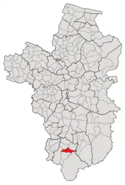 Subdistrict location in Ubon Ratchathani province | |
| Country | Thailand |
| Province | Ubon Ratchathani |
| District | Nam Yuen |
| Number of Muban | 15 |
| Number of Mu | 15 |
| Subdistrict established | 1979 |
| Area | |
| • Total | 93.65 km2 (36.16 sq mi) |
| Population (2021) | |
| • Total | 9,369 |
| • Density | 100.40/km2 (260.0/sq mi) |
| Time zone | UTC+7 (ICT) |
| Postal code | 34260 |
As of the 2021 consensus, it had a population of 9,369 people and 3,313 households.[1] Neighbouring subdistricts are (clockwise from the south) Si Wichian, Song, Kao Kham, Yang Yai, Ban Tum and Dom Pradit.[2][3][4]
History
The village of Bu Pueai was founded in 1911 by a group of 15 families of Kuy people led by "Saengkaen" (แสงแก่น) and was legally recognized by the local government three years later, with Peng Ong-Kham (เพ็ง โอ่งคำ) serving as the first village headman.[2] It was previously known as "Bu Ra-be" (บุระเบ๊ะ; pronounced in Thai as [bù rá.béː]), which is a Kuy language name made up of two parts: Bu บุ means degraded forest, and Ra-be ระเบ๊ะ refers to the Krabak (Anisoptera costata), an endangered species of plant found in the seasonal tropical forest in the area and is generally called "Pueai" by the Lao-origin people; the village was later renamed "Bu Pueai" in 1944 due to the mentioned reason.[2]
The village of Bu Pueai was controlled by the Yang subdistrict until it obtained subdistrict status in 1979 by absorbing eight other villages located in Yang's southeastern region.[5] However, nine years after becoming independent, its northernmost area, which consisted of six villages, was split off to form a new subdistrict, Yang Yai.[6]
After its establishment in 1979, Tambon Bu Pueai was governed by the Subdistricts Council of Bu Pueai, which was later upgraded to the Subdistrict Administrative Organization (SAO) in 1996.[2]
Geography
The tambon covers 93.65 km2 and is located in the central region of the Nam Yuen district. The area is mostly an undulating plateau and rolling plain used for agriculture.[2]
Administration
The subdistrict of Bu Pueai is divided into 15 villages (mubans; หมู่บ้าน).[1][2] As of the 2021 census, it had a population of 9,369 people with 3,313 households.[1]
The entire tambon is governed by the Subdistrict Administrative Organization of Bu Pueai (องค์การบริหารส่วนตำบลบุเปือย, Bu Pueai SAO).[1][2]
The following is a list of the subdistrict's mubans, which roughly correspond to the villages.[1]
| Village | Group (Mu) | Household | Population | |
|---|---|---|---|---|
| Romanized name | Thai name | |||
| Bu Pueai | บุเปือย | 1 | 224 | 644 |
| Nam Sap | น้ำซับ | 2 | 296 | 707 |
| Kaeng Ton | แก้งโตน | 3 | 328 | 1,074 |
| Samakki | สามัคคี | 4 | 144 | 410 |
| Prasert Saen Suk | ประเสริฐแสนสุข | 5 | 249 | 597 |
| Peut Udom | พืชอุดม | 6 | 258 | 620 |
| Kaset Sombun | เกษตรสมบูรณ์ | 7 | 341 | 846 |
| Pueai | เปือย | 8 | 263 | 967 |
| Phon Sawan | พรสวรรค์ | 9 | 202 | 604 |
| Bu Klang | บุกลาง | 10 | 208 | 651 |
| Non Ko | โนนก่อ | 11 | 70 | 212 |
| Sang Chiang In | สร้างเชียงอินทร์ | 12 | 244 | 743 |
| Kaset Phu Thong | เกษตรภูทอง | 13 | 158 | 405 |
| Kaset Udom | เกษตรอุดม | 14 | 187 | 529 |
| Kaset Pattana | เกษตรพัฒนา | 15 | 144 | 360 |
| Central House Registration | 0 | 0 | ||
| Total | 3,313 | 9,369 | ||
References
- "โครงสร้างข้อมูลสถิติจำนวนประชากร" (in Thai). Department of Provincial Administration of Thailand. 2021. Retrieved 15 December 2022.
- "ประวัติความเป็นมาของตำบลบุเปือย". Bupueai.go.th (in Thai). Subdistrict Administrative Organization of Bu Pueai. Archived from the original on 19 December 2022. Retrieved 18 December 2022.
- "ประกาศกระทรวงมหาดไทย เรื่อง การกำหนดเขตตำบลในท้องที่อำเภอน้ำยืน จังหวัดอุบลราชธานี (ฉบับที่ ๒) พ.ศ. ๒๕๕๒" (PDF). www.ratchakitcha.soc.go.th (in Thai). Royal Thai Government Gazette. 9 October 2009. Archived from the original (PDF) on 27 January 2012. Retrieved 18 December 2022.
- "ประกาศกระทรวงมหาดไทย เรื่อง การกำหนดเขตตำบลในท้องที่อำเภอน้ำยืนจังหวัดอุบลราชธานี" (PDF). www.ratchakitcha.soc.go.th (in Thai). Royal Thai Government Gazette. 17 December 1998. Archived from the original (PDF) on 18 December 2022.
- "ประกาศกระทรวงมหาดไทย เรื่อง ตั้งและเปลี่ยนแปลงเขตตำบลในท้องที่อำเภอน้ำยืน จังหวัดอุบลราชธานี" (PDF). www.ratchakitcha.soc.go.th (in Thai). Royal Thai Government Gazette. 8 August 1979. Archived from the original (PDF) on 19 December 2022. Retrieved 19 December 2022.
- "ประกาศกระทรวงมหาดไทย เรื่อง ตั้งและเปลี่ยนแปลงเขตตำบลในท้องที่อำเภอน้ำยืน อำเภอนาจะหลวย อำเภอเดชอุดม อำเภอตระการพืชผล และอำเภออำนาจเจริญ จังหวัดอุบลราชธานี" (PDF). www.ratchakitcha.soc.go.th (in Thai). Royal Thai Government Gazette. 21 October 1988. Archived from the original (PDF) on 5 June 2022. Retrieved 19 December 2022.