Yang Yai, Nam Yuen
Yang Yai (Thai: ยางใหญ่) is a tambon (subdistrict) located in the northern region of Nam Yuen district, in Ubon Ratchathani Province, Thailand.[1][2][3][4] It previously was the seat of a district named "Uthai Det Udom" (Eastern Det Udom) in Thailand's former province, Khukhan, until it was merged into the present Det Udom district and downgraded to the village in 1912.[2][5]
Yang Yai
ยางใหญ่ | |
|---|---|
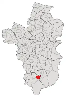 Subdistrict location in Ubon Ratchathani province | |
| Country | Thailand |
| Province | Ubon Ratchathani |
| District | Nam Yuen |
| Number of Muban | 12 |
| Number of Mu | 12 |
| Subdistrict established | 1988 |
| Area | |
| • Total | 46 km2 (18 sq mi) |
| Population (2021) | |
| • Total | 6,280 |
| • Density | 136.52/km2 (353.6/sq mi) |
| Time zone | UTC+7 (ICT) |
| Postal code | 34260 |
As of the 2021 consensus, it had a population of 6,280 people and 1,857 households in 12 administrative villages (Muban; บ้าน or หมู่บ้าน).[1] Neighbouring subdistricts are (clockwise from the south) Bu Pueai, Kao Kham, Yang, Non Sawan, and Phon Sawan.[2][3][6]
History
Before 1912, Yang Yai was one of the districts called "Uthai Det Udom" (Eastern Det Udom) in Thailand's former province, Khukhan, but, together with three other districts; Dom Pradit, Klang Det Udom, and Pachim Det Udom, it was merged to create a new district, Det Udom, with Mueang Det serving as the capital, and was also further downgraded to a village in the tambon Yang; the tambon's name refers to a group of three Yang villages in the region, including Yang Klang (Middle Yang), Yang Noi (Little Yang), and Yang Yai (Greater Yang).[5][7]
In 1979, five years after tambon Yang was transferred to a newly established district, Nam Yuen,[8][9] Yang Yai, along with eight other villages in Yang's southeast territory, was separated to form a new tambon, Bu Pueai.[10] However, it later became an independent tambon in 1988 by absorbing five other villages in the northern region of Bu Pueai.[2][11]
After independence, Tambon Yang Yai was governed by the Subdistrict Council of Yang until the council was later upgraded to the Subdistrict Administrative Organization (SAO) in 1996.[2]
Geography
The tambon covers 46 km2 and is located in the northern region of the Nam Yuen district, on Lam Dom Yai River's basin. The area is mostly an undulating plateau and rolling plain used for agriculture.[2]
Administration
The subdistrict of Yang Yai is subdivided into 12 administrative villages (mubans; หมู่บ้าน).[1][2] As of the 2021 census, it had a population of 6,280 people with 1,857 households.[1]
The entire tambon is governed by the Subdistrict Administrative Organization of Yang Yai (องค์การบริหารส่วนตำบลยางใหญ่, Yang Yai SAO).[1][2]
The following is a list of the subdistrict's mubans, which roughly correspond to the villages.[1]
| Village | Group (Mu) | Household | Population | |
|---|---|---|---|---|
| Romanized name | Thai name | |||
| Yang Yai | ยางใหญ่ | 1 | 327 | 934 |
| Dong Sawang | ดงสวาง | 2 | 145 | 449 |
| Dong Krashu | ดงกระชู | 3 | 206 | 684 |
| Sawai Noi | สวายน้อย | 4 | 135 | 443 |
| Kham Sa-at | คำสะอาด | 5 | 189 | 661 |
| Nong Muang | หนองม่วง | 6 | 141 | 488 |
| Maha Chai | มหาชัย | 7 | 107 | 342 |
| Saeng Charoen | แสงเจริญ | 8 | 85 | 282 |
| Yang Noi | ยางน้อย | 9 | 149 | 521 |
| Yang Pattana | ยางพัฒนา | 10 | 109 | 407 |
| Burapha Rung Rueang | บูรพารุ่งเรือง | 11 | 144 | 602 |
| Nong Kra Tai | หนองกระต่าย | 12 | 120 | 467 |
| Central House Registration | 0 | 0 | ||
| Total | 1,857 | 6,280 | ||
References
- "โครงสร้างข้อมูลสถิติจำนวนประชากร" (in Thai). Department of Provincial Administration of Thailand. 2021. Retrieved 15 December 2022.
- "สภาพทั่วไปและข้อมูลพื้นฐาน". Yangyailocal.go.th (in Thai). Subdistrict Administrative Organization. Archived from the original on 29 June 2022. Retrieved 20 December 2022.
- "ประกาศกระทรวงมหาดไทย เรื่อง การกำหนดเขตตำบลในท้องที่อำเภอน้ำยืน จังหวัดอุบลราชธานี (ฉบับที่ ๒) พ.ศ. ๒๕๕๒" (PDF). www.ratchakitcha.soc.go.th (in Thai). Royal Thai Government Gazette. 9 October 2009. Archived from the original (PDF) on 27 January 2012. Retrieved 18 December 2022.
- "พบบ่อน้ำเหม็นน้ำมันอีกแห่งที่บ้านยางใหญ่ พลังงาน จ.อุบลฯ เร่งสอบที่มา" (in Thai). Thai Rath. 11 February 2020. Archived from the original on 19 April 2021. Retrieved 20 December 2022.
- "แจ้งความกระทรวงมหาดไทย เรื่อง เลิกและยุบอำเภอต่างๆ ในมณฑลอุบลลงเป็นกิ่งอำเภอ" (PDF). www.ratchakitcha.soc.go.th (in Thai). Royal Thai Government Gazette. 28 July 1912. Archived from the original (PDF) on 5 June 2022. Retrieved 18 December 2022.
- "ประกาศกระทรวงมหาดไทย เรื่อง การกำหนดเขตตำบลในท้องที่อำเภอน้ำยืนจังหวัดอุบลราชธานี" (PDF). www.ratchakitcha.soc.go.th (in Thai). Royal Thai Government Gazette. 17 December 1998. Archived from the original (PDF) on 18 December 2022.
- "ประกาศ โอนอำเภอเดชอุดมและกิ่งอำเภอโพนงามจังหวัดขุขันธ์ไปขึ้นจังหวัดอุบลราชธานี" (PDF). www.ratchakitcha.soc.go.th (in Thai). Royal Thai Government Gazette. 23 December 1928. Archived from the original (PDF) on 31 October 2020. Retrieved 18 December 2022.
- "พระราชกฤษฎีกาตั้งอำเภอเขาวง อำเภอเชียงม่วน อำเภอดอนตาล อำเภอชาติตระการ อำเภอภูเรือ อำเภอเคียนซา อำเภอน้ำโสม อำเภอหนองวัวซอ และอำเภอน้ำยืน พ.ศ. ๒๕๑๗" (PDF). www.ratchakitcha.soc.go.th (in Thai). Royal Thai Government Gazette. 28 March 1974. Archived from the original (PDF) on 19 June 2022. Retrieved 18 December 2022.
- "ประกาศกระทรวงมหาดไทย เรื่อง แบ่งท้องที่ตั้งเป็นกิ่งอำเภอ" (PDF). www.ratchakitcha.soc.go.th. Royal Thai Government Gazette. 25 March 1969. Archived from the original (PDF) on 3 November 2019. Retrieved 18 December 2022.
- "ประกาศกระทรวงมหาดไทย เรื่อง ตั้งและเปลี่ยนแปลงเขตตำบลในท้องที่อำเภอน้ำยืน จังหวัดอุบลราชธานี" (PDF). www.ratchakitcha.soc.go.th (in Thai). Royal Thai Government Gazette. 8 August 1979. Archived from the original (PDF) on 19 December 2022. Retrieved 19 December 2022.
- "ประกาศกระทรวงมหาดไทย เรื่อง ตั้งและเปลี่ยนแปลงเขตตำบลในท้องที่อำเภอน้ำยืน อำเภอนาจะหลวย อำเภอเดชอุดม อำเภอตระการพืชผล และอำเภออำนาจเจริญ จังหวัดอุบลราชธานี" (PDF). www.ratchakitcha.soc.go.th (in Thai). Royal Thai Government Gazette. 21 October 1988. Archived from the original (PDF) on 5 June 2022. Retrieved 19 December 2022.