Buford Dam
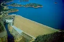
Buford Dam is a dam in Buford, Georgia which is located at the southern end of Lake Lanier,[4] a reservoir formed by the construction of the dam in 1956. The dam itself is managed by the United States Army Corps of Engineers.
| Buford Dam | |
|---|---|
 | |
 Location of Buford Dam in Georgia  Buford Dam (the United States) | |
| Country | United States |
| Location | Buford, Georgia |
| Coordinates | 34°09′37″N 84°04′26″W |
| Purpose | Multi-purpose |
| Status | Operational |
| Construction began | March 1, 1950 |
| Opening date | October 9, 1957 |
| Operator(s) | United States Army Corps of Engineers |
| Dam and spillways | |
| Type of dam | Earth fill dam |
| Impounds | Chattahoochee River |
| Height (thalweg) | 192 ft (59 m)[1] |
| Length | 1,630 ft (500 m)[2] |
| Width (crest) | 40 ft (12 m)[2] |
| Width (base) | 1,000 ft (300 m)[2] |
| Spillways | 1[2] |
| Spillway type | Uncontrolled chute[2] |
| Reservoir | |
| Creates | Lake Lanier |
| Commission date | 1958[3] |
| Annual generation | 250 GWh |
The dam is made of earth and concrete,[5] supplemented by three saddle dikes,[1] and was built to provide a water source for the Atlanta area, power homes, and prevent flooding of the Chattahoochee River.[6][7]
Electricity from the dam is marketed by the Southeastern Power Administration.[8]
Construction
Congress authorized construction of the dam in 1946,[9] and in 1949 the federal government gave the State of Georgia $750,000 (equivalent to $9,122,407 in 2023[10]) towards the building of the dam and accompanying powerhouse.[5]
On March 1, 1950, a groundbreaking ceremony was held, which included dignitaries such as Atlanta mayor William B. Hartsfield.[6][9] The United States Army Corps of Engineers oversaw the construction of the dam.[6]
During construction, land was bought in the area that would become the reservoir. Homes, churches, graveyards, and all other structures that would float were removed or burned.[6] Many residents in the reservoir area fought the buying of their homes with unsuccessful civil lawsuits.[6]
The powerhouse required crews to use dynamite to blast a U-shaped space through granite rock structures to hollow out an area for the powerhouse and release gates.[5] During the construction of the dam, Johnnie Callahan died during a rockslide when cutting an intake tunnel into the face of the granite rock wall.[11]
On February 1, 1956, the dam was completed when the sluice gates were closed and Lake Lanier began to fill.[12] Unit 2 began operation on June 20, 1957, Unit 3 on July 26, 1957, and Unit 1 on October 10, 1957.[13] The dam was dedicated on October 9, 1957.[9] The power plant went into full-scale operation in July 1958,[13] and the lake reached its intended level on August 1 of that year.[14]
Operation

When water is released from the dam's turbines, several sirens sound as well as an AM warning broadcast.[5]
The dam also has a 13.25 ft (4.04 m) diameter sluice which can be used to allow water to bypass the turbines.[1]
Downriver from the dam is a trout breeding hatchery, which is one of the southernmost hatcheries for trout, due to the cool temperature of the water that the dam releases.[5]
Powerhouse
The powerhouse at the dam has three generators: the main generator, a small 7.5 megawatt generator which runs constantly,[15] and two 60 megawatt generators that run twice daily during times of peak electricity demand.[9] The powerhouse provides 250 GWh (900 TJ) of electricity annually to the metro Atlanta area.[16] Control of the Buford Dam generators is done remotely from Carters Dam near Ellijay, Georgia via a microwave signal.[5][9] The power generated is delivered to Georgia Power.[1]
The powerhouse is cooled by the temperature of the water running through the dam, which is approximately 52 °F (11 °C) year-round.[5]
In 2002, the US Army Corps of Engineers spent $8.5 million to provide upgrades to the powerhouse.[17]
Goats
Because the earthen slopes on the outer side of the dam exceed 40% grade (21.8°, 1 in 2.5) and contain rocks and drop off points, they are too steep and unsafe to practically maintain by a landscaping crew.[18] To address this, the US Army Corps of Engineers use goats to maintain the grass and vegetation on the slope[9] as it is more economically viable than alternatives.[5] Goats have been used since the 1970s for this purpose, and there are sixteen goats that maintain the grounds, known as the "Chew Crew". There is also a donkey onsite that is used to protect the goats from coyotes.[18]
References
- United States. Army. Corps of Engineers (1975). Buford Dam and Lake Sidney Lanier Flood Control, Navigation, Power: Environmental Impact Statement (Report). Archived from the original on September 7, 2022. Retrieved August 19, 2022.
- "Buford Dam – Chattahoochee River, Georgia – Pertinent Data". janandpat.net. Archived from the original on April 26, 2017. Retrieved August 19, 2022.
- "Hydropower Facilities". United States Army Corps of Engineers. Archived from the original on April 22, 2021. Retrieved August 19, 2022.
- "Buford Dam Park on Lake Lanier". Archived from the original on August 18, 2022. Retrieved August 18, 2022.
- Cook, Chelsea (August 13, 2010). "Buford Dam: A unique little powerhouse". The Atlanta Journal-Constitution. Archived from the original on August 18, 2022. Retrieved August 19, 2022.
- Kerns, Sabrina (September 8, 2020). "Below the surface: How Lake Lanier came to be". Forsyth County News. Archived from the original on August 18, 2022. Retrieved August 19, 2022.
- Collier, Michael; Webb, Robert H.; Schmidt, John C. (2000). Dams and Rivers A Primer on the Downstream Effects of Dams. U.S. Geological Survey, Branch of Information Services. p. 39. ISBN 9780788126987. Archived from the original on September 7, 2022. Retrieved August 19, 2022.
- "Generation – Southeastern Power Administration". Energy.gov. Retrieved March 20, 2023.
- Gill, Jeff (September 5, 2009). "Inside Buford Dam, Lake Laniers powerhouse". The Gainesville Times. Archived from the original on September 7, 2022. Retrieved August 19, 2022.
- 1634–1699: McCusker, J. J. (1997). How Much Is That in Real Money? A Historical Price Index for Use as a Deflator of Money Values in the Economy of the United States: Addenda et Corrigenda (PDF). American Antiquarian Society. 1700–1799: McCusker, J. J. (1992). How Much Is That in Real Money? A Historical Price Index for Use as a Deflator of Money Values in the Economy of the United States (PDF). American Antiquarian Society. 1800–present: Federal Reserve Bank of Minneapolis. "Consumer Price Index (estimate) 1800–". Retrieved May 28, 2023.
- Hembree, Brandon (February 18, 2021). "History: Remembering a Buford Dam hero's contributions to Georgia". North Gwinnett Voice. Archived from the original on August 18, 2022. Retrieved August 19, 2022.
- Coggin, Dan (February 2, 1956). "Buford Dam Gates Shut To Form Lake Lanier on Poet's Loved River". The Atlanta Constitution. pp. 1, 5. Retrieved December 3, 2022 – via Newspapers.com.
- Tetra Tech (October 2015). Draft Environmental Impact Statement: Update of the Water Control Manual for the Apalachicola-Chattahoochee-Flint River Basin in Alabama, Florida, and Georgia and a Water Supply Storage Assessment (PDF) (Report). U.S. Army Corps of Engineers. Retrieved December 3, 2022.
- "Lake Lanier history: Completion of Buford Dam meant reservoir could fill". North Gwinnett Voice. October 17, 2021. Retrieved December 3, 2022.
- "Buford Dam – Lake Lanier". LakeLanier.com. Archived from the original on August 18, 2022. Retrieved August 19, 2022.
- "Buford Dam (U.S. National Park Service)". National Park Service. February 4, 2021. Archived from the original on August 18, 2022. Retrieved August 18, 2022.
- "Lake Lanier history: Crews complete structures that would become Buford Dam". North Gwinnett Voice. September 21, 2021. Archived from the original on August 18, 2022. Retrieved August 19, 2022.
- Barker, John (March 16, 2018). "Goats At Dam Cut Landscaping Costs For Corps". Patch.com. Archived from the original on August 18, 2022. Retrieved August 19, 2022.
- Gillespie, Deanna M. (2016). ""Revolutionize Life in the Chattahoochee River Valley": Buford Dam and the Development of Northeastern Georgia, 1950-1970". Georgia Historical Quarterly. 100 (4): 404–440. JSTOR 44651734 – via JSTOR.