Buhl, Minnesota
Buhl is a city in Saint Louis County, Minnesota, United States. Its population was 952 at the 2020 census.[4]
Buhl | |
|---|---|
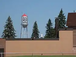 Buhl Water Tower | |
| Motto: The Finest Water in America | |
 Location of the city of Buhl within Saint Louis County, Minnesota | |
| Coordinates: 47°29′37″N 92°46′25″W | |
| Country | United States |
| State | Minnesota |
| County | Saint Louis |
| Area | |
| • Total | 3.51 sq mi (9.10 km2) |
| • Land | 3.31 sq mi (8.57 km2) |
| • Water | 0.21 sq mi (0.53 km2) |
| Elevation | 1,522 ft (464 m) |
| Population (2020) | |
| • Total | 952 |
| • Density | 287.87/sq mi (111.14/km2) |
| Time zone | UTC-6 (Central (CST)) |
| • Summer (DST) | UTC-5 (CDT) |
| ZIP codes | 55713 |
| Area code | 218 |
| FIPS code | 27-08524[3] |
| GNIS feature ID | 0660903[2] |
| Website | www |
U.S. Highway 169 serves as a main route in the community.
The city's motto is "The Finest Water in America".
History
A post office called Buhl has been in operation since 1900.[5] The city was named for Frank H. Buhl, a businessperson in the mining industry.[6] Buhl was incorporated in 1901.[6]
Geography
According to the United States Census Bureau, the city has a total area of 3.56 square miles (9.22 km2); 3.35 square miles (8.68 km2) is land and 0.21 square miles (0.54 km2) is water.[7]
Demographics
| Census | Pop. | Note | %± |
|---|---|---|---|
| 1910 | 1,005 | — | |
| 1920 | 2,007 | 99.7% | |
| 1930 | 1,634 | −18.6% | |
| 1940 | 1,600 | −2.1% | |
| 1950 | 1,462 | −8.6% | |
| 1960 | 1,526 | 4.4% | |
| 1970 | 1,303 | −14.6% | |
| 1980 | 1,284 | −1.5% | |
| 1990 | 915 | −28.7% | |
| 2000 | 983 | 7.4% | |
| 2010 | 1,000 | 1.7% | |
| 2020 | 952 | −4.8% | |
| U.S. Decennial Census[9] | |||
2010 census
As of the census[10] of 2010, there were 1,000 people, 430 households, and 228 families living in the city. The population density was 298.5 inhabitants per square mile (115.3/km2). There were 496 housing units at an average density of 148.1 per square mile (57.2/km2). The racial makeup of the city was 93.7% White, 1.7% African American, 2.1% Native American, 0.4% Asian, and 2.1% from two or more races. Hispanic or Latino of any race were 0.3% of the population.
There were 430 households, of which 25.1% had children under the age of 18 living with them, 39.8% were married couples living together, 8.1% had a female householder with no husband present, 5.1% had a male householder with no wife present, and 47.0% were non-families. 40.2% of all households were made up of individuals, and 18.6% had someone living alone who was 65 years of age or older. The average household size was 2.11 and the average family size was 2.88.
The median age in the city was 42 years. 22.7% of residents were under the age of 18; 6.2% were between the ages of 18 and 24; 24.1% were from 25 to 44; 26.1% were from 45 to 64; and 20.9% were 65 years of age or older. The gender makeup of the city was 52.8% male and 47.2% female.
2000 census
As of the census of 2000,[3] there were 983 people, 405 households, and 240 families living in the city. The population density was 299.0 inhabitants per square mile (115.4/km2). There were 432 housing units at an average density of 131.4 per square mile (50.7/km2). The racial makeup of the city was 94.91% White, 0.71% African American, 2.75% Native American, 0.20% Asian, 0.31% from other races, and 1.12% from two or more races. Hispanic or Latino of any race were 0.51% of the population. 20.5% were of Finnish, 15.1% German, 10.7% Italian, 6.8% English and 5.8% Norwegian ancestry.
There were 405 households, out of which 25.4% had children under the age of 18 living with them, 46.7% were married couples living together, 8.9% had a female householder with no husband present, and 40.5% were non-families. 35.1% of all households were made up of individuals, and 18.3% had someone living alone who was 65 years of age or older. The average household size was 2.21 and the average family size was 2.87.
In the city, the population was spread out, with 25.9% under the age of 18, 7.9% from 18 to 24, 24.1% from 25 to 44, 22.4% from 45 to 64, and 19.6% who were 65 years of age or older. The median age was 39 years. For every 100 females, there were 118.4 males. For every 100 females age 18 and over, there were 101.1 males.
The median income for a household in the city was $31,574, and the median income for a family was $34,464. Males had a median income of $35,938 versus $21,538 for females. The per capita income for the city was $14,828. About 7.2% of families and 13.2% of the population were below the poverty line, including 21.9% of those under age 18 and 11.0% of those age 65 or over.
Politics
| Year | Republican | Democratic | Third parties |
|---|---|---|---|
| 2020 | 55.1% 305 | 41.9% 232 | 3.0% 17 |
| 2016 | 50.0% 265 | 40.5% 214 | 9.5% 50 |
| 2012 | 32.1% 163 | 63.2% 321 | 4.7% 24 |
| 2008 | 29.5% 159 | 67.2% 362 | 3.3% 18 |
| 2004 | 29.7% 167 | 68.7% 387 | 1.6% 9 |
| 2000 | 24.5% 141 | 64.0% 368 | 11.5% 66 |

References
- "2020 U.S. Gazetteer Files". United States Census Bureau. Retrieved July 24, 2022.
- U.S. Geological Survey Geographic Names Information System: Buhl, Minnesota
- "U.S. Census website". United States Census Bureau. Retrieved January 31, 2008.
- "2010 Census Redistricting Data (Public Law 94-171) Summary File". American FactFinder. U.S. Census Bureau, 2010 Census. Retrieved April 23, 2011.
- "St. Louis County". Jim Forte Postal History. Archived from the original on January 15, 2016. Retrieved August 7, 2015.
- Upham, Warren (1920). Minnesota Geographic Names: Their Origin and Historic Significance. Minnesota Historical Society. p. 478.
- "US Gazetteer files 2010". United States Census Bureau. Archived from the original on January 25, 2012. Retrieved November 13, 2012.
- "Recent Media Coverage". Archived from the original on September 7, 2008. Retrieved September 18, 2008.
- "Census of Population and Housing". Census.gov. Retrieved June 4, 2015.
- "U.S. Census website". United States Census Bureau. Retrieved November 13, 2012.
- "Minnesota Secretary of State - 2020 Precinct Results Spreadsheet".
- "Minnesota Secretary of State - 2016 Precinct Results Spreadsheet".
- "Minnesota Secretary of State - 2012 Precinct Results Spreadsheet".
- "Minnesota Secretary of State - 2008 Precinct Results Spreadsheet".
- "Minnesota Secretary of State - 2004 Precinct Results Spreadsheet".
- "Minnesota Secretary of State - 2000 Precinct Results Spreadsheet".
