Bulungan Regency
Bulungan Regency is a regency of North Kalimantan Province in Indonesia. It covers an area of 13,181.92 km2 and had a population of 112,663 at the 2010 Census[2] and 151,844 at the 2020 Census;[3] the official estimate as at mid 2022 was 157,593 (comprising 84,071 males and 73,522 females).[1] The administrative centre is at Tanjung Selor.
Bulungan Regency
Kabupaten Bulungan (Indonesian) | |
|---|---|
 Coat of arms | |
| Motto(s): Tenguyun (Together) | |
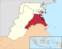
 Location of Bulungan Regency in North Kalimantan. | |
| Country | Indonesia |
| Province | North Kalimantan |
| Capital | Tanjung Selor |
| Area | |
| • Total | 13,181.92 km2 (5,089.57 sq mi) |
| Population (mid 2022 estimate) | |
| • Total | 157,593 |
| • Density | 12/km2 (31/sq mi) |
| [1] | |
| Time zone | UTC+8 (Central Indonesian Time) |
| Website | bulungan.go.id |
History
The Bulangan Regency was originally co-extensive with what subsequently became the province of North Kalimantan. On 8 October 1997 the town of Tarakan was cut out of the regency to become an independent city. Two years later, on 4 October 1999, the remaining territory of the regency was split to create two additional regencies - Malinau Regency and Nunukan Regency. On 17 July 2007, three more districts (kecamatan) was split from Bulungan Regency to form a new regency, Tana Tidung Regency.[4]
Bulangan Regency had originally been part of the East Kalimantan province, but in 2012 it - together with the areas carved out of it in 1997, 1999 and 2007 - became part of the newly created North Kalimantan province. Tanjung Selor in Bulungan Regency was designated as the province's capital.[5]
Administrative Districts
The regency is divided into ten districts (kecamatan), tabulated below with their areas and their populations at the 2010 Census[2] and the 2020 Census,[3] together with the official estimates as at mid 2022.[1] The table also includes the locations of the district administrative centres, the number of administrative villages in each district (a total of 74 rural desa and 7 urban kelurahan), and its postal codes.
| Name of District (kecamatan) | Area in km2 | Pop'n Census 2010 | Pop'n Census 2020 | Pop'n Estimate mid 2022 | Admin centre | No. of villages | Post codes |
|---|---|---|---|---|---|---|---|
| Peso (a) | 3,142.79 | 4,327 | 4,400 | 4,479 | Long Bia | 10 | 77261 |
| Peso Hilir (Lower Peso) | 1,639.71 | 3,484 | 4,134 | 4,168 | Long Tungu | 6 | 77262 |
| Tanjung Palas Barat (West Tanjung Palas) | 1,064.51 | 5,832 | 6,416 | 6,502 | Long Beluah | 5 | 77217 |
| Tanjung Palas | 1,755.74 | 14,032 | 17,556 | 17,884 | Gunung Putih | 9 (b) | 77211; 77214-77216 |
| Tanjung Selor (c) | 677.77 | 39,439 | 56,569 | 59,172 | Tanjung Selor Hilir | 9 (d) | 77211 & 77212 |
| Tanjung Palas Timur (East Tanjung Palas) | 1,277.81 | 8,651 | 18,020 | 19,512 | Tanah Kuning | 8 | 77215 |
| Tanjung Palas Tengah (Central Tanjung Palas) (e) | 624.95 | 7,527 | 11,567 | 12,261 | Salim Batu | 3 | 77216 |
| Tanjung Palas Utara (North Tanjung Palas) | 806.34 | 8,954 | 10,651 | 10,744 | Karang Agung | 6 | 77218 |
| Sekatak (f) | 1,993.98 | 9,278 | 10,842 | 10,899 | Sekatak Buji | 22 | 77263 |
| Bunyu | 198.32 | 11,139 | 11,689 | 11,972 | Bunyu Barat | 3 | 77281 |
| Totals | 13,181.92 | 112,663 | 151,844 | 157,593 | Tanjung Selor | 81 |
Notes: (a) including 5 offshore islands. (b) including 4 kelurahan. (c) including 7 offshore islands.
(d) including 3 kelurahan. (e) including 65 offshore islands. (f) including 10 offshore islands.
Gallery

See also
References
- Badan Pusat Statistik, Jakarta, 2023, Kabupaten Bulungan Dalam Angka 2023 (Katalog-BPS 1102001.6501)
- Biro Pusat Statistik, Jakarta, 2011.
- Badan Pusat Statistik, Jakarta, 2021.
- "UU No. 34 Tahun 2007 tentang Pembentukan Kabupaten Tana Tidung Di Provinsi Kalimantan Timur". peraturan.bpk.go.id (in Indonesian). Audit Board of Indonesia. 2007. Retrieved 31 January 2022.
- "Sejarah | Kalimantan Utara". kaltaraprov.go.id. Retrieved 31 May 2021.