Côte Aftissate-Boujdour
The Côte Aftissate-Boujdour is a Ramsar Site that stretches along 50 kilometres (31 mi) of the Western Sahara coast south of Boujdour. It includes the fishing village of Aftissat.
| Côte Aftissate-Boujdour | |
|---|---|
 | |
| Coordinates | 25°48′N 14°35′W |
| Area | 11,700 ha (45 sq mi) |
| Designation | Ramsar Site, Wetland of International Importance[1] |
| Designated | 16 April 2019 |
Location
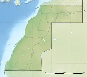
The Côte Aftissate-Boujdour is located in Jraifia commune, Boujdour Province in the Laâyoune-Sakia El Hamra region.[2] The protected area covers 117 square kilometres (45 sq mi).[1] It extends along the Atlantic coast for 50 kilometres (31 mi). The site was designated on 16 April 2019. Along this section of the coast a beach and mobile dunes separate the sea from a continuous low-lying furrow of land below a 70 metres (230 ft) high sea cliff.[2]
Ecology
The Côte Aftissate-Boujdour is at the southern edge of the Palearctic ecozone. The climate is strongly influenced by coastal upwelling.[2] The wetland is a resting area for Palearctic seabirds, waders and land migrants, and for passerines in particular. Over 1% of the biogeographic population of species such as the lesser black-backed gull (Larus fuscus) are found in the wetland in winter. The dry area is home to the endemic gecko Saurodactylus brosseti and other rare and endemic species.[3]
Notes
Sources
- "Côte Aftissate-Boujdour", Protected Planet, retrieved 2021-10-23
- "Côte Aftissate-Boujdour", Ramsar Sites Information Service, retrieved 2021-10-23
- "Twelve new Ramsar sites for Morocco", Smart Water Magazine, 3 September 2019, retrieved 2021-10-23
Capital: Boujdour | ||
| Municipalities |  | |
| Rural communes | ||
| Other locations |
| |