Caledonia, Ohio
Caledonia is a village in Marion County, Ohio, United States. The population was 560 at the 2020 census.
Caledonia, Ohio | |
|---|---|
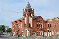 Village Hall on the Public Square | |
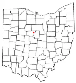 Location of Caledonia, Ohio | |
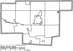 Location of Caledonia in Marion County | |
| Coordinates: 40°38′10″N 82°58′9″W | |
| Country | United States |
| State | Ohio |
| County | Marion |
| Township | Claridon |
| Area | |
| • Total | 0.24 sq mi (0.63 km2) |
| • Land | 0.24 sq mi (0.63 km2) |
| • Water | 0.00 sq mi (0.00 km2) |
| Elevation | 994 ft (303 m) |
| Population (2020) | |
| • Total | 560 |
| • Density | 2,314.05/sq mi (894.51/km2) |
| Time zone | UTC-5 (Eastern (EST)) |
| • Summer (DST) | UTC-4 (EDT) |
| ZIP code | 43314 |
| Area code | 419 |
| FIPS code | 39-10954[3] |
| GNIS feature ID | 1056754[2] |
| Website | http://www.caledonia-village.com |
History
The area known as Caledonia – along the banks of the Whetstone (Olentangy) River, & part of the ecologically significant Sandusky Plains prairie region, which spanned Southern Crawford, Southern Wyandot, & Northern Marion County – was historically the hunting grounds of the Shawnee people, & became the refugee grounds of the Wyandot. At the time of white settlement, several Wyandot peoples lived along the Whetstone near today's Village of Caledonia; & many indigenous cultural objects were found in the region.
The village of Caledonia was platted in 1834 by Samuel Holmes. Originally called "Van Buskirk," the growing community was renamed after Caledonia, an ancient name for Scotland, the ancestral home of a large share of the first settlers.[4]
Caledonia's growth & prosperity was largely due to the railroad lines that, by the 1850s, ran through the center of town. The success of these rail lines made Caledonia a major stop-over & embarkment site along the lines between Marion & Galion; & encouraged the growth of Caledonia's monumental Public Square beginning with the Village's formal incorporation in 1873. Boosterist mayor J. Blanchard was a driving force behind the construction of the Public Square.
Major historic buildings on the Public Square include Village Hall (1891), the Union Block Building (1884), the Temple & Masonic Block Buildings (1897), the Underwood Block Building (1875), a canopy gas station (1920s-1930s) & the "Class of '55" Building, historically known as the Clark Building (1880s-1890s). All buildings on the Public Square besides the gas station are built in a distinctive vernacular Italianate style – some, with added Classical Revival elements like broken pediments & hipped roofs.
Caledonia experienced two significant downtown fires in its history: one, in 1884, that took out several historic frame structures, & led to a first era of masonry construction. Sherwood Anderson describes the 1884 blaze in his memoirs. A second fire, in 1896, destroyed the former Temple & Opera Block frame buildings on the Southeastern corner of the Public Square; today's brick Temple & Masonic Block building were built in their place in 1897.
Throughout its history, Caledonia was a major agricultural, shopping, entertainment, & fraternal hub for the region. A grain elevator just north of the railroad tracks has served the community since at least the 1890s. Downtown Caledonia & the Public Square was a booming destination for local farmers & rural residents in a fifteen-mile stretch of region between Marion, Bucyrus, Galion, & Mt. Gilead.
Caledonia was also known regionally as a major "organization town." At the height of American fraternalism, Caledonia hosted almost a dozen fraternal organizations & auxiliaries – including the Knights of Pythias Calanthe Lodge #106, the Oliver Lodge #448 of the Free & Accepted Masons, & the International Order of Oddfellows (I.O.O.F.) #299. Once located each in their own buildings, Caledonia's surviving Masonic & Oddfellows Lodge now both meet in the I.O.O.F. Hall above the Union Block Building. Caledonia also boasts an active American Legion (Post #401), which offers a canteen in the Union Block building, an annual Memorial Day service, & other community events.
In the 1920s, Caledonia became a stop along the "Harding Highway" – originally called the "Marion Way" of the National Road. This spoke of America's early highway system followed already-established market roads; & brought regional traffic from Galion directly through the heart of the Public Square. Amongst growing concern over traffic fatalities, the road – which eventually became U.S. 30-South, then Highway 309 – was bypassed around downtown Caledonia. A secondary business hub consisting largely of gas stations & related automotive businesses eventually developed along today's Highway 309 bypass. By the 1950s, automotive transport had entirely replaced passenger rail transportation; & Caledonia's once-bustling railway depot was demolished.
Caledonia's population peaked in the 1970s: fueled, in part, by a major oil boom in neighboring Morrow County in the 1960s, which brought an influx of new families to the region. The 1970s saw a heyday of historic preservation, public history, & civic pride on the Public Square, with the celebration of Caledonia's centennial in 1970, the U.S. Bicentennial in 1976, & the Marion County Semisesquentennial in 1977.
At its height, downtown Caledonia boasted multiple grocery stores, a television supply store, a drug store, a bakery, several restaurants, four bars, & four churches. While many of Caledonia's downtown businesses flourished until the 1980s, the triple blows of deindustrialization (including the closure of Marion Power Shovel), the "get big or get out" push in North-Central Ohio agriculture, & the construction of new big box stores along Route 95 on the outskirts of Marion began pushing local businesses out. By 2010, the majority of Caledonia's Public Square was vacant. In the early 2020s, community members began organizing to revitalize downtown Caledonia.
Caledonia Today
Today, concerned citizens & several non-profits are working together to recognize Caledonia's important history, & to revitalize Caledonia's Public Square through creative placekeeping, public history, historic preservation, & economic development. The Village of Caledonia undertook a major oral history project, the Caledonia Public Square Memories & Futures Project, in 2022.
The Caledonia Farmers Market was founded in 2021, & serves a broad North-Central Ohio regional community with a seasonal farmers' market held on the Public Square on Saturdays from 10AM-1PM EST from June thru September. The market – which features produce & value-added food producers as well as artisan crafts – has been a major force in revitalizing interest in the Public Square. The market features an annual summer music series with live outdoor performances on market Saturdays between July & September.
Friends of Caledonia is another 501(c)(3) organization dedicated to revitaliation of downtown Caledonia, through community festivals & traditions. Friends of Caledonia hosts a weekly food truck parked outside the Masonic Block building, & is working to revive the Caledonia Farmers' Festival: a beloved community tradition from the 1970s-1990s.
Marion Voices Folklife + Oral History – Marion County's countywide folk & cultural arts for social justice organization – is also based in Caledonia.
Caledonia is home to three [National Register of Historic Places]-listed properties: the Caledonia Bowstring Bridge, which was moved to Caledonia from its original location in Western Marion County near the railroad community of Espyville in the 1970s.[5] The Southeastern corner of Caledonia's Public Square is home to the Temple & Masonic Block buildings, built in 1897, & listed to the [National Register of Historic Places] in 2021. The Caledonia Memorial Methodist Church on E. Marion Street was also listed to the [National Register of Historic Places] in the 1970s.
The wider Caledonia region is also home to three eco-tourism destinations: Terradise Nature Center – the historic home of conservationists & historians Trella & Ray Romine – on the west bank of the Whetstone, Terradise Nature Preserve (maintained by the Marion County Parks District), & ECO Center: an environmental education center offering summer camps, community festivals, & a popular Hallowe'en haunt attraction.
Geography
Caledonia is located at 40°38′10″N 82°58′9″W (40.636068, -82.969301).[6]
According to the United States Census Bureau, the village has a total area of 0.23 square miles (0.60 km2), all land.[7]
Caledonia is located along the Whetstone River in the Sandusky Plains: a historically important tended prairie region, & one of only a handful of post-glaciation prairie regions in Ohio.
Demographics
| Census | Pop. | Note | %± |
|---|---|---|---|
| 1870 | 419 | — | |
| 1880 | 627 | 49.6% | |
| 1890 | 757 | 20.7% | |
| 1900 | 682 | −9.9% | |
| 1910 | 562 | −17.6% | |
| 1920 | 492 | −12.5% | |
| 1930 | 526 | 6.9% | |
| 1940 | 629 | 19.6% | |
| 1950 | 655 | 4.1% | |
| 1960 | 673 | 2.7% | |
| 1970 | 792 | 17.7% | |
| 1980 | 759 | −4.2% | |
| 1990 | 644 | −15.2% | |
| 2000 | 578 | −10.2% | |
| 2010 | 577 | −0.2% | |
| 2020 | 560 | −2.9% | |
| U.S. Decennial Census[8] | |||
2010 census
As of the census[9] of 2010, there were 577 people, 232 households, and 174 families living in the village. The population density was 2,508.7 inhabitants per square mile (968.6/km2). There were 260 housing units at an average density of 1,130.4 units per square mile (436.4 units/km2). The racial makeup of the village was 97.4% White, 1.6% African American, 0.2% Asian, 0.7% from other races, and 0.2% from two or more races. Hispanic or Latino of any race were 0.5% of the population.
There were 232 households, of which 31.5% had children under the age of 18 living with them, 57.3% were married couples living together, 12.1% had a female householder with no husband present, 5.6% had a male householder with no wife present, and 25.0% were non-families. 21.1% of all households were made up of individuals, and 10.3% had someone living alone who was 65 years of age or older. The average household size was 2.49 and the average family size was 2.86.
The median age in the village was 40.2 years. 24.1% of residents were under the age of 18; 6.6% were between the ages of 18 and 24; 26% were from 25 to 44; 27.2% were from 45 to 64; and 16.3% were 65 years of age or older. The gender makeup of the village was 47.5% male and 52.5% female.
2000 census
As of the census[3] of 2000, there were 578 people, 230 households, and 169 families living in the village. The population density was 2,568.0 inhabitants per square mile (991.5/km2). There were 242 housing units at an average density of 1,075.2 units per square mile (415.1 units/km2). The racial makeup of the village was 99.31% White, 0.35% African American, and 0.35% from two or more races. Hispanic or Latino of any race were 0.35% of the population.
There were 230 households, out of which 32.6% had children under the age of 18 living with them, 60.0% were married couples living together, 8.7% had a female householder with no husband present, and 26.5% were non-families. 23.9% of all households were made up of individuals, and 12.2% had someone living alone who was 65 years of age or older. The average household size was 2.51 and the average family size was 2.92.
In the village, the population was spread out, with 25.3% under the age of 18, 7.1% from 18 to 24, 30.3% from 25 to 44, 25.4% from 45 to 64, and 11.9% who were 65 years of age or older. The median age was 37 years. For every 100 females there were 95.9 males. For every 100 females age 18 and over, there were 97.3 males.
The median income for a household in the village was $40,804, and the median income for a family was $46,563. Males had a median income of $34,375 versus $22,344 for females. The per capita income for the village was $17,423. About 1.9% of families and 4.9% of the population were below the poverty line, including none of those under age 18 and 5.3% of those age 65 or over.
Education
River Valley Local School District operates two elementary schools, one middle school, and River Valley High School.[10]
From the 1920s until 2021, Caledonia had a public library: a branch of Marion Public Library. This branch closed in the middle of the COVID-19 pandemic, & does not have plans to reopen. The library space is currently vacant.[11]
Notable people
- Warren G. Harding was a resident of Caledonia during his childhood, and worked for a brief period of time at the community newspaper, The Argus.
- Sherwood Anderson spent several years of his childhood in Caledonia, where his father worked as a harness-maker. Anderson based elements of his 1926 semi-autobiographical novel Tar: A Midwest Childhood on his time in Caledonia.[12]
- Daniel Richard Crissinger was educated in Caledonia and served as chairman of the Federal Reserve Board between 1923 and 1927.
References
- "ArcGIS REST Services Directory". United States Census Bureau. Retrieved September 20, 2022.
- "US Board on Geographic Names". United States Geological Survey. October 25, 2007. Retrieved January 31, 2008.
- "U.S. Census website". United States Census Bureau. Retrieved January 31, 2008.
- Overman, William Daniel (1958). Ohio Town Names. Akron, OH: Atlantic Press. p. 21.
- "National Register Information System". National Register of Historic Places. National Park Service. July 9, 2010.
- "US Gazetteer files: 2010, 2000, and 1990". United States Census Bureau. February 12, 2011. Retrieved April 23, 2011.
- "US Gazetteer files 2010". United States Census Bureau. Archived from the original on July 2, 2012. Retrieved January 6, 2013.
- "Census of Population and Housing". Census.gov. Retrieved June 4, 2015.
- "U.S. Census website". United States Census Bureau. Retrieved January 6, 2013.
- "Homepage". River Valley Local Schools. Retrieved March 1, 2018.
- "Hours & Locations". Marion Public Library. Retrieved March 1, 2018.
- Rideout, Walter B. (2006). Sherwood Anderson: A Writer in America, Volume 1. Madison, WI: University of Wisconsin Press. p. 20. ISBN 978-0-299-21530-9.
Municipalities and communities of Marion County, Ohio, United States | ||
|---|---|---|
| City |  Map of Ohio highlighting Marion County | |
| Villages | ||
| Townships | ||
| Unincorporated communities | ||
| Ghost town | ||