California Historical Landmarks in Lake County
This list includes properties and districts listed on the California Historical Landmark listing in Lake County, California. Click the "Map of all coordinates" link to the right to view a Google map of all properties and districts with latitude and longitude coordinates in the table below.
| Image | [1] | Landmark name | Location | City or town | Summary |
|---|---|---|---|---|---|
Upload Photo |
426 | Site of Stone and Kelsey Home | Main St. & Bell Hill Rd. 38°58′42″N 122°50′36″W |
Kelseyville | |
Upload Photo |
427 | Bloody Island Massacre | State Hwy 20 & Reclamation Rd. 39°08′56″N 122°53′17″W |
Upper Lake | Also called the Battle of Bloody Island |
Upload Photo |
429 | Lower Lake Stone Jail | 16118 Main St. 38°54′38″N 122°36′35″W |
Lower Lake | |
 Old Lake County Courthouse |
897 | Old Lake County Courthouse | 255 N Main St. 39°02′36″N 122°55′02″W |
Lakeport | Also on the NRHP list as NPS-70000134 |
Upload Photo |
467 | St. Helena Toll Road and Bull Trail | State Hwy 29 and Hill Ave. 38°44′54″N 122°36′59″W |
Middletown | |
Upload Photo |
450 | Stone House | 18174 Hidden Valley Rd 38°48′33″N 122°34′22″W |
Hidden Valley Lake | |
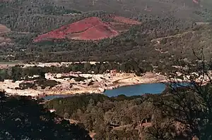 Sulphur Bank Mine |
428 | Sulphur Bank Mine | Sulphur Bank Mine 39°00′14″N 122°39′59″W |
Clearlake Oaks |
References
- "California Historical Landmarks By County". Ohp.parks.ca.gov. Retrieved 2019-04-03.
See also
Wikimedia Commons has media related to California Historical Landmarks in Lake County, California.
- List of California Historical Landmarks
- National Register of Historic Places listings in Lake County, California
This article is issued from Wikipedia. The text is licensed under Creative Commons - Attribution - Sharealike. Additional terms may apply for the media files.